Imaging California: South Coast Pilot Study

Frank W. Davis (Principal Investigator)
Michael Bueno1
Janine M.Stenback2

Institute for Computational Earth System Science
University of California
Santa Barbara, CA 93106-3060

Final Report submitted to the

National Aeronautics and Space Administration

in fulfillment of

Interagency Agreement Number 6CA38584

Report Date, December 20, 1997

  • Project Summary
  • Background
  • Methods
  • Results
  • Concluding Comments
  • References

  • 1. PROJECT SUMMARY

    The objective of this project has been to map, model and monitor land cover and provide a seamless image-base for the Southwest Ecoregion of California. The broader objective has been to develop and test an approach for monitoring inter-annual land cover dynamics in California using multi-temporal, digital Thematic Mapper (TM) imagery.

    We have constrained the monitoring approach to be as simple, portable, and analyst-independent as possible, even though this required some sacrifice in mapping accuracy. Important features of the monitoring approach developed here are:

  • 1) reliance on readily available commercial image processing and GIS software (ARC/INFO and GRID software from the Environmental Systems Research Institute (ESRI));
  • 2) minimal dependence on an image analyst's judgement in mapping land use/land cover;
  • 3) use of a single date of TM imagery from each monitoring period;
  • 3) use of relatively simple procedures for radiometric rectification that do not require sophisticated radiative transfer models or extensive atmospheric measurements;
  • 4) use of readily available ancillary geospatial information for image segmentation and classification;
  • 4) hierarchical stratification of the study area into ecological regions and subregions for image analysis;
  • 5) automated classification of current land use and land cover using land use/land cover data from the previous time period(s); and,
  • 6) aggregation of pixel-based land cover maps into larger areal units for reporting land cover change.
  • The monitoring approach was used to quantify changes in land cover in southwestern California between Summer 1990 and Summer 1993. Portions of five TM scenes were required to cover the study area. Accuracy of mapping and monitoring was assessed using ground data and air photos.

    Using a ten-class land use/land cover system adopted for this project, low overall map accuracies of 50-60% were obtained for the single date classifications of 1990 and 1993 imagery. Using a simpler six-class system it was possible to achieve single-date accuracies of 85-90%. These accuracies seem quite reasonable given the large and heterogeneous study area (portions of four TM scenes) and the constraint of single-date imagery, and suggest that the map-guided algorithm developed here has real potential in an operational monitoring system. However, even higher accuracies would be needed to reliably monitor modest changes in land use and land cover.

    One obvious limitation of the current study was the inconsistency and low reliability of the original source maps when applied at 25m resolution for map-guided classification of 1990 imagery. An encouraging result was the ability of the classification algorithm to produce a product of considerably higher accuracy than the original input map.

    This project has provided a prototype for future cooperative efforts between NASA and state and local governments in applying Landsat data and new methods of image interpretation to assess statewide, regional and local consequences of environmental change. This report as well as the data products from the project will be made available via the World Wide Web at www.biogeog.ucsb.edu.


    2. BACKGROUND

    2.1. Project Rationale and Organization

    The emerging view of ecosystem management has had a significant impact on conservation planning by focusing more effort on habitat conservation and sustainable resource management over large areas as the preferred alternative to expensive recovery planning for single species. This paradigm shift requires, more than ever, a comprehensive, coordinated planning effort involving a partnership of federal, state, local and private conservation interests. Such planning depends on consistent environmental data and information over large, multi-jurisdictional planning regions.

    Our two year pilot study sought to provide methodology and software for the construction of a seamless image database for statewide land cover classification and change detection. We addressed all of conceptual and operational steps needed to create a spatially and temporally indexed database with the appropriate level of land cover classification to be useful and meaningful for ecoregional planning.

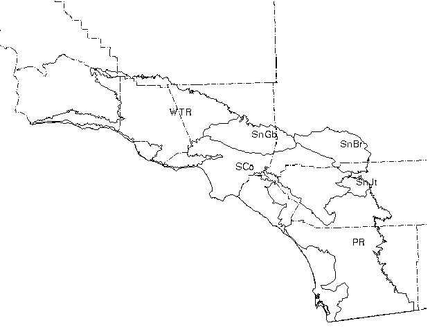
    The methods were tested and refined in mapping the Southwest Ecoregion of California, an area of high environmental and biological diversity and rapid human population growth. The South Coast Region was proposed as a pilot area because of the need to map and monitor resources in this rapidly changing environment, in particular the coastal sage scrub habitat. This habitat type is important to monitor because it is home to many threatened species, including the recently listed California gnatcatcher. The conservation planning for this wildlife species is unique in that state and federal agencies, and developers have agreed to preserve the coastal sage scrub habitat while also permitting limited urban development.

    The pilot study has involved three different groups: the Biogeography Lab of the University of California at Santa Barbara (UCSB), The Resources Agency of the State of California, and the Southwest Ecoregion Planning Group. The group at UCSB, under the leadership of PI Davis, has been responsible for all technical research on image processing and change detection strategies and for production of all map products. Janine Stenback, of The Resources Agency has been responsible for arranging meetings between UCSB scientists and the Southwest Ecoregion Planning Group, and has also seen that this project has been well coordinated with ongoing efforts by the California Environmental Resource Evaluation System (CERES) to develop standard formats and metadata for geospatial data. The project has been steered by input from the Southwest Ecoregion Planning Group (SWEPG), a multiagency committee that represents the local users of the information we have developed (Table 1). This group has been instrumental in developing a land cover classification scheme and resolving issues of appropriate spatial resolution.

    Table 1. Southwest Ecoregion Planning Group

  • Edie Allen, U. of California, Riverside
  • Cameron Barrows, The Nature Conservancy
  • Gary Bell, The Nature Conservancy
  • Jan Beyers, US Forest Service - Riverside Fire Lab
  • Slader Buck, US Marine Corp - Camp Pendleton
  • Dick Crowe, Bureau of Land Management
  • Bob Dean, USDA Natural Resource Conservation Service
  • Roland DeGouvenain, Bureau of Land Management
  • Janet Fairbanks, San Diego Association of Governments
  • Patricia Lock-Dawson, Bureau of Land Management
  • Steve Loe, USDA Forest Service
  • Kim Nicol, California Department of Fish and Game
  • Nanette Pratini, U. of California, Riverside
  • Ray Sauvajot, National Park Service, Monica Mtns NRA
  • Tom Scott, U. of California, Riverside
  • John Stevenson, USDA Forest Service
  • Peter Stine, California Science Center, USGS-Biological Resources Division
  • Tom Sturm, US Geological Survey
  • Bob Wheeler, So. Cal. Coalition of Resource Conservation Districts
  • Tom White, USDA Forest Service
  • 2.2. Remote Sensing to Monitor Land Cover Dynamics

    Imagery acquired from aircraft and satellites has been used for decades to monitor land cover change. Much of the research to date on use of digital imagery has focused on processing methods for detecting changes in land cover between two image dates. It is not our intention here to review the very large literature on this subject. Dobson et al. (1997) identify seven different change detection algorithms that have been used by the remote sensing community:

    1. Change Detection Using Write Function Memory Insertion for Visual Identification of Change (combine individual bands from different dates to highlight areas of change)
    2. Multi-date Composite Image Change Detection (create an n-dimensional image from two or more dates and classify using unsupervised or supervised classification of the original bands or band transformations such as principal component transforms).
    3. Image Algebra Change Detection (apply band differencing or band ratioing)
    4. Post-classification Comparison Change Detection (classify imagery from each date and compare images on a pixel-by-pixel basis)
    5. Multi-date Change Detection Using A Binary Mask Applied to the Base Image (compare spectral data from two dates to identify areas of change, classify these areas, and compare them to land cover in a classified "base image" to estimate land cover changes to and from the different land cover categories).
    6. Multi-date Change Detection Using Ancillary Data Source as Tb (same as the previous approach except that an alternative map source is used as the base map for quantifying change).
    7. Manual, On-screen Digitization of Change (visually delineate and classify areas of change that are evident based on joint display of imagery from different dates).

    Each algorithm has weaknesses and strengths. All require that the imagery be geometrically rectified with high accuracy. Radiometric rectification is especially important with those procedures that involve direct comparison of pixel DN values, that is, procedures 2, 3, 5, and 6 above. Procedures 1 and 7 depend heavily on analysts' interpretation and judgment. Post-classification change analysis (algorithm 4) has been widely used but relies on producing maps of high accuracy for both time periods. Algorithms 5 and 6 have been applied successfully by programs such as NOAA's Coastal Change Analysis Program (C-CAP), but results depend heavily on setting the threshold for change/no change (especially problematic over heterogeneous and wildfire-prone areas such as southern California areas).

    The approach taken by this project is essentially that of post-classification change comparison, with the difference that the baseline maps are used to prepare the map for the current time period, and with spatial filtering and aggregation to reduce the need for very high map accuracy in each time period.


    3. METHODS

    3.1. Study Area

    The study area was the Southwestern region of California, exclusive of the Channel Islands, as defined in Hickman (1993) (Figure 1). The Southwestern Region includes 3,383,160 ha, roughly 8 percent of the area of California. (Note: Much of the text in this section is taken directly from Davis et al. (1995)). It lies within the California Floristic Province and is divided into four subregions and six districts. Subregions include the South Coast, Channel Islands, Transverse Ranges and Peninsular Ranges. Districts of the Transverse Ranges include the San Bernardino Mountains, San Gabriel Mountains, and Western Transverse Ranges. The San Jacinto Mountains are considered a separate district of the Peninsular Ranges.

    The region is bounded by the Sonoran Desert and Mojave Desert regions on the east and the crest of the Santa Ynez Mountains and the upper Cuyama Valley on the north. The boundary at the southern end of the region is defined as the Mexican border, although vegetation similar to that found in southwest San Diego County extends south into Baja California for roughly 300 km, where there is an abrupt transition to a more arid adapted flora.

    Based on 1990 census data, 16,539,858 people (56% of California's total population) reside in the region. From 1980 to 1990, the population of San Bernardino and Riverside Counties grew at a rate of more than 50%, San Diego County grew at a rate of 30-40%, Orange and Ventura Counties expanded by 20-30%, and Santa Barbara and Los Angeles Counties grew 5-20% (Goodenough 1992).

    Forty-six percent of the region is lower than 500 m above mean sea level. Only 3.5% of the region is above 2000 m, and < 0.1% is above 3000 m. The southern half of the region is dominated by the Peninsular Ranges. The northern portion of the region is part of the complex Transverse Ranges province. At least five main mountain ranges comprise the Pensinsular Ranges of southern California: the San Jacinto Range (summit elevation 3,325 m), the Santa Rosa Range (2680 m); the Santa Ana Mountains (1755 m); the Agua Tibia Mountains (1880 m) and the Laguna Mountains (1940 m). The basement rock of the Peninsular Ranges is a granitic batholith, consisting mainly of quartz diorite dating from the lower Cretaceous period (Norris and Webb 1990). Major fault valleys include the Elsinore fault zone and the San Jacinto fault zone.

    The major mountain ranges of the Transverse Range include the Santa Ynez Mountains (1325 m), the Topatopa Range (2060 m), the Santa Monica Mountains (925 m), the San Gabriel Mountains (3080 m) and the San Bernardino Mountains (3385 m). The San Gabriel and San Bernardino are mainly granitic and metamorphic rocks from the lower Cretaceous. The Santa Monica Mountains are comprised largely of Miocene marine sedimentary rocks and volcanic rocks, whereas the Santa Ynez and Topatopa Mountains are predominantly Eocene interbedded marine sandstones and shales.

    There is a strong climatic gradient from low coastal areas to high elevations of the interior, and a secondary gradient from north to south. Mean temperatures along the coast range from around 5°C in winter to 10°C in the summer. In contrast, mid-elevations further east range from 2°C in winter to 22 °C in summer. Annual precipitation averages 250-500 mm at lower elevations to greater than 1500 mm at high elevations in the Transverse Ranges. Total annual precipitation at coastal localities decreases from 400 mm in the north to 250 mm at San Diego. However, southern areas receive more summer precipitation associated with tropical hurricanes. Annual moisture balance ranges from a surplus of 100-200 mm in the mountains to deficits of 200-600 mm at lower elevations. Within the region, topography and variable coastal influence


    Figure 1. The Southwest Region of California, and subregions, as defined by Hickman (1994). Subregions include Western Transverse Ranges (WTr), San Gabriel Mountains (SnGb), San Bernadino Mountains (SnBr), South Coast (Sco), San Jacinto Mountains (SnJt), and Peninsular Ranges (PR). The mapped region extends from the U.S.border northwestward to Point Conception.combine to produce at least 5 general climatic types, including warm steppe, warm mediterranean, cool mediterranean, martime mediterranean and microthermal (montane).

    Soil patterns are very complex, reflecting interactions among geology, topography, climate, geomorphology and vegetation. In general, mollisols predominate in the interior faulted valleys, while a diverse group of alfisols occur on the terraced coastal sediments. The mountain soils are not well characterized, but are likely to be comprised of poorly developed, excessively drained entisols. Upland natural areas of this region are dominated by 24 major terrestrial community types. Annual grasslands, woodlands and soft chaparral communities dominate lower elevations, giving way to hard chaparral at mid- elevations, and then to mixed evergreen forest and mixed conifer forest at the highest elevations. Slopes adjacent to the Mojave and Sonoran Deserts support drier shrubland types, as well as pinyon and juniper woodlands.

    Sixty percent of the land area is in private ownership, much of it at lower elevations and already converted to urban or agricultural uses. The steeper, montane areas are largely managed by public agencies such as the U. S. Forest Service (29% of the region), Bureau of Land Management (3%), Department of Defense (2%), and the California Department of Parks and Recreation (2%). Lands owned and managed by Native Americans cover only 2% of the region, mainly in San Diego County. Four National Forests (from south to north - the Cleveland, San Bernardino, Angeles, and Los Padres) are managed primarily for watershed conservation, recreation, and fire protection.

    3.2. Thematic Mapper Imagery

    The TM imagery needed to cover this region includes 4 partial TM scene footprints. We excluded the Palos Verdes Peninsula from the analysis because it would have necessitated acquiring an additional TM scene. Including this small area would not have substantively affected the results of the study.The 1990 TM scenes were collected in late August/early September (Table 2). All were geometrically terrain corrected and resampled to 25m resolution by the USGS EROS Data Center for the California Gap Analysis Project (Davis et al. 1995). All the images are relatively cloud free and visual investigation suggests very good rectification with ground features.

    Table 2. TM scenes used for this study.
    Path/RowScene I.D. DateNotes
    40/36 (San Bernardino) y52370174208/27/90
    40/37 (Santa Ana)y5237017422 8/27/90
    41/36 (Los Angeles) y52377174809/3/90
    42/36 (Santa Barbara) y52368175428/25/90
    40/36 (San Bernardino) 94010007-014/13/93 July-August imagery too cloudy to be useful
    40/37 (Santa Ana)94011001-01 8/19/93Extensive stratus clouds off coast
    41/36 (Los Angeles) y53465175048/26/93
    42/36 (Santa Barbara) 94010012-016/30/93 August imagery too cloudy to be useful

    The 1990 imagery was segmented into ecological subregions, as defined by Hickman (1994, Figure 1), in order to account for systematic spatial variation in topography, vegetation and soils, and air quality. This resulted in a total of 10 sub-images that received separate processsing from this step on.

    Two of the 1993 scenes were obtained at approximately the same times of year as the 1990 scenes (Table 2). Unfortunately, the remaining areas were only covered by spring and early summer imagery. The scene for Path/Row 40/37, which covers much of the southern portion of the study area including coastal San Diego County and Orange County, proved to be especially problematic. Although the land areas were cloud-free, extensive marine stratus clouds led to sensor saturation and hysteresis so that west-to-east scan lines of coastal areas were artificially bright, producing pronounced image striping over much of western San Diego and Orange County. We masked these areas from any subsequent change analyses. In an operational monitoring program we would have been forced to correct the striping problem or to acquire a different image.

    We should also add that summer 1993 followed two average to above-average rainfall years, whereas summer 1990 was at the end of an extensive, five-year drought in southern California that had pronounced effects on surface water levels, residential and agricultural irrigation practices, and native perennial vegetation. These hydrological and ecological effects were expressed as marked differences in imagery from the two periods.

    The 1993 scenes were first geometrically rectified from their original Space Oblique Mercator (SOM) projection to the Albers Projection. This step was performed using a terrain-correcting rectification procedure (GCPWorks) available in the PCI image processing package. A total of roughly 300 control points and USGS 3 arc-second digital elevation data were used to co-register 1993 and 1990 imagery. These points were acquired from obvious image tie points (e.g., road intersections, small dams, coastline features) obtained by visual interpretation of both images. After the collection of ground control points, the 1993 data were re-sampled using cubic convolution. Most registration tests showed errors of less than one pixel between the two time periods (e.g., Figure 2). Following geometric rectification, the imagery was segmented into 10 sub-images for subsequent processing steps.


    Figure 2. Subimage from urban location in the study region showing coregistration of TM Band 4 in 1990 and 1993. Images are superimposed, showing good co-registration of roads and other well-defined features.

    We did not correct for atmospheric effects in the 1990 imagery, because the correction would not have affected the outcome of our classification procedure. However, we did radiometrically rectify the 1993 imagery to be statistically consistent with the 1990 scenes. This facilitated visual comparison of imagery from the two time periods and added consistency to results of subsequent classification procedures. Each 1993 sub-image was radiometrically adjusted using the procedure described by Schott et al. (1988). This method involves applying a linear transformation to the image from the second time period to make it appear as if the surface was imaged through the same atmosphere as the first. "Pseudoinvariant" features that are constantly bright over time (e.g., urban surfaces) are identified by the analyst through interactively setting image DN thresholds in specific bands. Once identified, these areas are treated as reference areas and a linear transformation is applied to match the histograms of DN values for each band in each time period (see Schott et al. (1988) for details).

    For both 1990 and 1993 sub-images, we next derived brightness, greenness, and wetness (BGW) images by applying the linear coefficients published by Crist and Cicone (1984). Finally, prior to image classification we masked any apparent clouds in the imagery. Areas with clouds in either 1990 or 1993 imagery were masked after DN threshholding to guide on-screen digitizing of cloud boundaries.

    3.3. Land Cover Classification and Mapping

    Based on discussions with SWEPG members, we decided to use a very simple classification system essentially comparable to Anderson Level 1 or, for natural vegetation, to the highest level of Federal Geographic Data Committee's (FGDC) vegetation classification system (Table 2). The system distinguishes five natural vegetation classes based on canopy structure, three anthropogenic cover types based on land cover and use, water, and bare soil or rock. The system has obvious shortcomings. For example, a single urban class is used to capture all built environments, regardless of density or use. However, the simplicity of the system was viewed as appropriate for the kind of regional, interagency monitoring activities envisioned by the group, and was also expected to be easier to map with acceptable accuracy than a more detailed classification scheme.

    Table 2. Land Cover Classes

  • 1. Water
  • 2. Urban
  • 3. Barren
  • 4. Grassland (<20% shrub or tree cover)
  • 5. Cropland
  • 6. Shrubland (>20% shrub cover and <20% tree cover
  • 7. Woodland/Forest (>20% tree cover)
  • 8. Orchard
  • 9. Desert scrub
  • 10. Wetland
  • .

    Image classification was performed by an algorithm developed for this project and referred to as "iterative, map-guided image classification." The approach requires that a reasonably accurate and appropriately detailed land cover map (e.g., a map from the baseline or previous mapping period) exists for the region of interest. An unsupervised classification is performed on the image, and the resulting classified but unlabeled map is then intersected with the existing map to calculate the proportion of each spectral cluster in each land cover class. The spectral cluster with the highest level of association (i.e., the highest ratio of pixels in a cluster and information class combination relative to the sum of pixels in the cluster in all classes) is assigned to the corresponding information class. The pixels in that spectral cluster are then masked in the image and the procedure (i.e., unsupervised classification, comparison to map, labeling of the cluster in highest concordance with a map class) is repeated with the remaining data. The level of association from the first iteration is multiplied by .95, and this value is set as the threshold for assignment in the next iteration. If no cluster reached the threshold in subsequent iterations, the current highest association becomes the new threshold. Processing continues in iterative fashion until all pixels are assigned to a land cover or until a stopping rule is invoked.

    The rationale for the iterative procedure is as follows:

    Best results are obtained from map-guided image classification when the input map data have the same resolution as the imagery. We did not have a TM-based land cover map available for producing the 1990 map. Instead, we derived the 1990 regional land cover map using 1990 county land cover maps prepared for Riverside, Orange and San Diego Counties. These were produced at roughly 1:24,000 scale by interpretation of large scale air photos. These maps cover only part of the total region, and we were forced to use smaller scale (1:100,000) maps prepared by the California Gap Analysis project (Davis et al. 1995) over the remainder of the study region.

    The 1993 land cover map was produced by applying the image classifier to 1993 imagery using the TM-derived land cover map from 1990 required to use a smaller scale (1:100,000) land cover map for the remaining areas (Davis et al. 1995). These maps were combined to form a seamless, 25m map for the entire ecoregion (Figure 3). This input map was used to derive a new regional 1990 land cover map.

    3.4. Comparison of 1990 and 1993 Maps

    Before quantifying changes in land use land cover, we applied logic rules to eliminate ecologically nonsensical change. The logic filters that were applied to the imagery were specific to the study area and the two time periods of image, but the procedure is more general. The following transitions were considered spurious:

    1. grassland to forest (It is unlikely that grassland would convert to forest in three years).
    2. barren to forest. (It is unlikely that barren would convert to forest in three years. Such a report is possibly due to mis-registration.)
    3. water to shrub or forest. (In general, there was much more water in 1993 than in 1990.)
    4. urban to any other type
    5. orchard to water, forest, crop or shrub.
    6. cropland to forest or shrubs.

    In an effort to reduce misregistration effects which are inherent in per-pixel image classifications, and to reduce noise caused by incorrectly classified pixels, we agglomerated the per-pixel classifications into "areal reporting units (ARUs)" of 10, 100 and 1000 acre resolutions. We counted the number of pixels for each class for each time period occurring in each ARU. These counts were then compared on a class by class basis at the ARU level in order to identify changes between both time periods. An ARU with no change would have the same number of pixels for each class for both times

    3.5. Classification Accuracy

    Forty randomly located sample cells measuring 100 meters by 100 meters at ground scale were assigned to each of four 1:24,000 scale USGS 7.5 minute topo quads. Cells immediately contiguous to other cells were omitted from the sample. A total of 153 sample cells were used. We printed the sample cells on acetate overlays, along with major roads and map edge neatlines that matched the topo maps. At that scale, the sample cells were 4.2 millimeters on a side.

    We used 1:65,000 scale color IR photographs (July 1990) and 1:48,000 color photos (February 1993) to make an accuracy assessment of the 1990 and 1993 TM images. We used a zoom transfer scope to superimpose the air photos on the overlays and map, and assigned each sample cell to the dominant land cover class.

    To assess repeatability and accuracy of the air photo interpretation, we selected a random subset of 69 sample cells to be interpreted by a second person using the same cover class definitions.

    In general, we had the most trouble consistently defining samples cells as shrub, barren, or grassland in situations where vegetation cover was sparse and required precise and accurate estimation of shrub cover to determine whether there was sufficient cover to assign the area shrubland status. Another problem was making consistent determinations for mixed pixels. Although the location of the sample cells could probably be determined on the air photos to within a fraction of the width of the cell, this may have been enough to make a difference in determination of cell cover type in a few cases.


    4. RESULTS

    4.1. Analyst Performance in Map Accuracy Assessment

    The two photointerpreters did not always agree in their classification of sampled areas (Tables 3 and 4). In double-blind analysis of 69 samples, they agreed only 77% of the time in interpreting the 1990 air photos and only 74% of the time in assessing the 1993 photos. Urban and orchard classes were assigned with the highest consistency. As noted above, assigning classes to mixed areas and to open shrubland/grassland areas were the main sources of uncertainty. These results suggest that some of the classification error measured in the regional land cover maps could derive from error in photointerpretation.

    Table 3. Confusion matrix showing class assignments by two photointerpreters for 1990 air photos. A sample of 69 areas was randomly selected from four scattered 7.5-minute quadrangles in the study region.


    Table 4. Confusion matrix showing class assignments by two photointerpreters for 1993 air photos. The same areas were analyzed as in the 1990 air photos.


    4.2. Classification Error in the 1990 and 1993 Land Cover Maps

    Disappointing results were obtained in classifying 1990 TM imagery. Overall agreement between air photo samples and TM-derived samples was only 55%, and kappa-based accuracy was only 40% (Table 5). Several factors contributed to this low accuracy:

    Needless to say, the low accuracy of the 1990 land cover map eliminates any possibility of obtaining accurate estimates of land cover change in the region between 1990 and 1993 based on these map classes. However, a simpler classification scheme (for example, water, urban, barren/herbaceous, shrubs, trees), would have higher accuracy and might be useful for some kinds of monitoring objectives. The accuracy of the 1990 map based on this 5-class scheme was 85%, still not high enough to monitor land cover change with much confidence (Table 7).

    Table 5. Confusion matrix showing classification error for the 1990 land cover map, based on 153 random samples from four 7.5-minute quadrangles. Rows are based on intepretation of air photos, and columns are TM-derived classes. The Kappa statistic is calculated based on the equation in Congalton (1991).


    Table 6. Confusion matrix comparing map class in 1990 air photo samples (rows) and the 1990 land cover maps (columns) used to train the iterative map-guided classification algorithm.


    Classification acuracy for the 1993 land cover map was slightly higher than that for 1990 (59% agreement, Table 8). It is interesting to note that the classes that were mapped with highest accuracy in 1990 (e.g., urban, orchard) were also mapped with higher accuracy in 1993. As in 1990, there was high confusion between barren, grassland and cropland cover types, and between forest and orchard, so that reasonable accuracies could be achieved using a simpler classification scheme based on dominant life forms (Table9).

    Table 7. Confusion matrix for 1990 air photos versus TM-derived land cover for a simplified classification scheme (n=146).


    Table 8. Confusion matrix for the 1993 TM-derived land cover map.


    Table 9. Confusion matrix for the 1993 TM-derived land cover map based on a simplified land cover classification system.

    4.3. Change Analysis, 1990 to 1993

    Given the low accuracy of the 25 m products when evaluated using 1 ha reference sites and the ten-class classification system, there was little reason to analyze change by direct comparison of the 1990 and 1993 maps. However, a comparison based on the simplified classification system is more reasonable, given the higher single-date accuracies. The possible reliability of such a comparison is illustrated in Table 10, which compares urban change as predicted in the maps from that detected in the analysis of the air photos. The results are not encouraging. The one sample that both analysts agreed had been converted from non-urban to urban cover was classified as urban in the 1990 map and other in the 1993 map. Only half of the areas classified by the analysts as urban in both time periods were similarly classified in the TM-based maps. We should note that such errors are in large part related to the scale of the sampling unit.and occurred almost exclusively in mixed areas that included both urban development and open space. On a per-pixel basis our accuracies may have been higher.

    Table 10. Confusion matrix for urban change analysis based on air photos versus TM-derived maps.


    5. CONCLUDING COMMENTS

    Members from the Southwest Ecoregion Planning Group reviewed our results for the southernmost TM scene that covered San Diego County and parts of Orange and western Riverside Counties. The results were mixed. Even with our relatively crude land cover classification system, some members expressed optimism that our results would at least point them in the right direction when trying to detect change. Other members expressed less enthusiasm, desiring better results and stricter categorization. We do not think that our solution is in any way complete, but find the approach sufficiently encouraging to continue refining the algorithms.

    Our intent was to create a reproducible TM-based monitoring process requiring as little human intervention or subjectivity as possible. We have come close to this goal, and recognize that a number of factors have operated from the start to lower the quality of our results. In particular, it may be unreasonable to expect high accuracies using single-date imagery, and a more robust map-guided classification procedure may be needed.

    After reassembling the classified maps for both time periods, we observed some sharp discontinuities at the boundaries of the subecoregions in the 1993 product. Some of the land cover boundaries might be expected to be sharp between the subecoregion boundaries, but others are clearly erroneous classifications. These artifacts are likely due to the seasonal differences between the 1990 and 1993 imagery. In order to accurately detect change using satellite imagery from two dates, it is important to employ imagery from dates as close to the same time of year as possible. While all of our 1990 data were from late summer, one 1993 image was from June and another from April. The change in seasonality between these two dates has greatly affected the results for these scenes, and it is difficult to imagine any change detection algorithm that would perform well under these conditions.

    Another problem with our input data was the algorithm used to georeference and terrain-correct the imagery. While the 1990 data were uniformly processed by EROS, the 1993 data were processed using a different algorithm provided by PCI. Although we had sub-pixel registration quality in some areas, in other areas co-registration accuracy was difficult to determine due to the lack of recognizable and stable image features. We suspect that registration errors may often exceed one pixel in rugged areas.

    Finally, we expect that much of the uncertainty in assessing change from 1990 to 1993 is related to the very different climate conditions during those years.

    In contrast to traditional change detection methods, the output product is not a differenced image, but instead a series of change maps for each land cover type illustrating gain or loss of each land cover type. This output can also be summarized tabularly by any regular or irregular spatial summary unit. We have not yet performed a formal analysis of the effect of Areal Reporting Unit size on the reliability of the assessment, but it appears that the patterns of change are highly scale dependent. We are continuing to explore this component of our monitoring approach with the goal of developing a more formal model of scaling properties of land cover dynamics.


    6.REFERENCES

    Congalton, R. G. 1991. A review of assessing the accuracy of classifications of remotely sensed data. Remote Sensing of Environment 37: 35-46.

    Crist, E. and R. Cicone. 1984. A physically-based transformation of Thematic Mapper data - the TM tasseled cap. IEEE Transactions on Geoscience and Remote Sensing GE-22: 256-263.

    Davis, F.W., P. A. Stine, D.M. Stoms, M. I. Borhert, and A. D. Hollander. Gap analysis of the actual vegetation of California 1. The Southwestern Region. Madrono 42: 40-78.

    Dobson, J. E., et al. 1997. NOAA Coastal Change Analysis Program (C-CAP): guidance for regional implementation. NOAA Technical Report NMFS 123. Department of Commerce.

    Goodenough, R. 1992. The nature and implications of recent population growth in California. Geography 77: 123-133.

    Hickman, J. C. (ed.). 1993. The Jepson manual of higher plants of California. University of California Press, Berkeley.

    Scott, J. R., C. Salvaggio, and W. D. Volchok. 1988. Radiometric scene normalization using pseudoinvariant features. Remote Sensing of Environment 26: 1-16.

    Strahler, A. H. 1981. Stratification of natural vegetation for forest and rangeland inventory using Landsat digital imagery and collateral data. International Journal of Remote Sensing 2: 15-41.