Table of Contents
Identification Information
Data Quality Information
Spatial Data Organization Information
Spatial Reference Information
Entity and Attribute Information
Distribution Information
Metadata Reference Information
Contact Information
Layer Contents
I. IDENTIFICATION INFORMATION
Data Set Identity: landcov
Description:
This layer is the land-cover/land use data compiled for the California Gap
Analysis Project. It contains vegetation attributes for landscape scale map
units, including canopy dominant species, canopy density, presence of regional
endemic species, and inclusion of wetland habitats.
Although polygons are classified into several
schema (California Natural Diversity Data Base or "Holland" system,
California Wildlife Habitat Relationships habitat types),
data on presence of dominant
canopy species are provided to allow customized classifications to meet a
user's needs.
Supplemental Information: n/a
Data Set Status: in use
West Bounding Coordinate: -124.5048
Theme Keyword: Surface Vegetation, Land Cover, Habitat, Landuse
Browse Graphic File Name: landcov.gif
Use Restrictions: n/a
Access Limitations:
There are no restrictions on access to this dataset. However, the data are
subject to revision. To ensure that the user has the latest version, copies
should only be obtained from the UCSB ftp or web site or from
California Department of Fish and Game.
Native Data Set Environment:
ARC/INFO software version 7.0.3 running on IBM RS6000 with AIX 3.2.5
Raster File Format: n/a
Attribute Accuracy: unknown
Attribute Accuracy Explanation:
Because source information ranged widely in date and reliability, the current
database is uneven in both level of detail and accuracy. We did not have the
resources to assess the statistical accuracy of the land-cover/vegetation map
and associated database. However, we have appraised the product using less
formal methods that have guided our use of the product.
The distribution of each dominant plant species in the coverage was compared
to the documented distribution recorded in the
CalFlora database
which was derived from the Munz flora and
revised with some more current data. Outlying locations of species in the GAP
database were re-examined to either confirm that the location was documented
in the data source or to change the species code if it appeared to be an
incorrect interpretation or a data input error. A similar comparison was made
for each community type with the written description in Holland, 1986.
Logical Consistency Report:
Each attribute label was confirmed to be a member of the set of valid values
by comparing codes for species, community types and habitat types with a list
of legitimate codes and names. Illegal codes were re-examined to identify the
type of error and were corrected appropriately. Each map unit was tested with
the ARC LABELERROR command to confirm that each has one and only one label.
The proportion of cover types in each polygon was checked to sum to 100%
(i.e., a code of 9).
Completeness Report:
At the landscape scale of mapping land-cover, it is not possible to include
all vegetation and habitat features. The following guidelines were used in
interpretating and generalizing the source data.
The minimum mapping unit is 100 ha for upland community types and 40 ha for
wetland communities. To account for mosaics of communities below this
resolution, each map unit was attributed with up to three community types,
each of which had to be >10% of the map unit area. The spatial location of
individual stands of vegetation therefore are not provided.
The classification was based on dominant overstory species. The minimum
canopy closure criterion is 25%. Thus forest and woodland formations must
have >25% tree cover, shrublands must have <25% tree cover and >25%
shrub cover, and herbaceous types must have <25% trees, <25% shrubs, and
>2% herbs.
Because the map is of actual, not potential, vegetation, the existing types
were recorded even where there is evidence of recent disturbance. One
exception is recently burned chaparral, which was typed as chaparral unless
there was some strong evidence of type conversion.
Species must represent >20% of the canopy of the cover type in the map unit
to be listed as a dominant species.
Some attributes are not completed for all map units. Wetland data and crown
closure are only recorded if determined from aerial photos or other high
resolution source. Data were not readily available for all map units and thus
these fields may be blank (i.e., value of "0"). In the Mojave
Desert region, species data were often indeterminate from TM imagery, and high
resolution sources were unavailable. In many instances, therefore, only a
community type is assigned to such map units, and the species data are blank.
The project guidelines in effect when the Sonoran Desert and Southwestern
California regions were being mapped only required primary and secondary types
to be recorded. The tertiary type and species data in these two regions are
always blank, except where modified in later revisions.
The attributes for developed and agricultural lands contain variable depth of
detail, depending on the source information used. For example, in some areas,
the community type was assigned to "Agricultural Land" of unknown
uses. Where such lands were known to be either cropland or orchard/vineyard,
they were so indicated. In a few sites, these may be further subdivided such
as Irrigated Hayfield or Evergreen Orchard. Such distinctions are useful for
modeling wildlife species distributions because the WHR database distinguishes
the habitat suitability among these for different species. However, it should
be noted that our classification is inconsistently applied, with greater
detail in some places than others. It was decided that it was worth
maintaining the most information possible at the expense of a consistent, but
less detailed, classification.
Horizontal Positional Accuracy: n/a
Source Information:
This section begins with general methods used for the CA-GAP mapping of land
cover, followed by details on regional sources. Polygon boundaries were
derived from photointerpretation of 1990 Landsat Thematic Mapper digital
images, supplemented by 1990 HAP photography and large scale vegetation maps.
Attribute data came from the 1990 HAP photography, the 1930's VTM Survey Maps
(i.e., Wieslander), field visits, and large scale vegetation maps.
Southwestern California sources: The sources described above were all
used for this region, as well as the SANDAG MSCP land cover map, the
Metropolitan Water District map of the San Diego Pipeline No. 6 study area,
and a land cover map of Camp Pendleton Marine Corps Base.
Davis, F. W., P. A. Stine, D. M. Stoms, M. I. Borchert, and A. D. Hollander,
1995. Gap analysis of the actual vegetation of California: 1. The Southwestern
Region. Madroño, 42: 40-78.
Sonoran Desert sources: The basic approach in delineating areas was to
divide the desert region into rocky slopes, bajadas, and valley floors as
viewed on 1990 TM images. An extensive field survey of the dominant perennial
vegetation of the entire region was undertaken for determining the floristic
information. Because of the extent of the area to be inventoried, the
greatest coverage of the desert could be affected by using the major highways
and other roads and tracks of the desert as transects. Approximately 10,000
miles of road were traveled and 86% of the map units were viewed.
Subsequent to the draft GAP land-cover map, the Bureau of Land Management and
the California Department of Fish and Game conducted a joint effort to enhance
the map with added detail for critical wildlife habitats in their Northern and
Eastern Colorado Desert planning area (Dorweiler 1997). Sand dunes and dry
lake beds were delineated from helicopter overflights using a global
postioning system to determine geographic coordinates. Desert dry wash
woodland was mapped independently in the southern portion through supervised
classification of July, 1994, Landsat TM imagery after masking known areas of
creosote scrub and mountains to reduce confusion of spectral signatures. Due
to difficulties separating dry wash woodland in the northern part of the
planning area, BLM used on-screen digitizing from orthophoto quads and hand
drawn maps instead. Based on field work and examining aerial photos, some
additional corrections in classification were made to the draft GAP map. The
California GAP obtained a June, 1997, version of the BLM map and incorporated
most of the modifications. Polygon boundaries were generalized and attributes
adjusted as needed to be consistent with the database design philosophy and
structure of the GAP land-cover map.
Gray, M. V., 1994. A Digital Multipurpose Vegetation Map for the Colorado
Desert of California. Masters thesis, Department of Geography, University
of California, Santa Barbara.
Mojave Desert sources: The Mojave Region vegetation database was
developed using existing maps as baseline source data, including the East
Mojave Resource Inventory from Southern California Edison, the BLM West Mojave
map (Clark, personal communication), Edwards Air Force Base, and a BLM/USGS
map derived from MSS imagery. Maps were updated and refined using Thematic
Mapper satellite imagery, a current 1:150,000 road atlas (to identify areas
of residential or industrial development), and extensive reconnaissance level
field survey. The revisions made by the Bureau of Land Management for their
Northern and Eastern Colorado Desert planning area (Dorweiler 1997) included a
small part of the southern Mojave Desert region. The revisions were
incorporated into the final GAP land-cover as described above for the Sonoran
Desert region.
An accuracy check of a portion of the coverage was conducted using
data obtained by the BLM during vegetation characterization studies
in the east Mojave in 1975. Four hundred sixty-two transects were
measured in this study and a listing of one to four visually dominant
species for the stand in which each transect was placed was made.
Each transect was not specifically georeferenced; however, its
location was recorded to the resolution of a section (typically one
square mile). A GIS coverage of all sections containing transects was
overlain on the vegetation coverage and a listing of the cover types
occurring within the sections was obtained. Visual dominant species
were compared with Holland cover types for each section and if the
dominant species could be cross referenced to any of the Holland cover
types occurring within the section, the mapping was considered to be
accurate. The accuracy check in the east Mojave subsampled 1.6% of
the total regional land area. Overall accuracy was 84.0% for
the subsample; however, accuracy among the eight cover types occurring
on the transects varied between 65% and 100%.
Thomas, K. A., 1996. Vegetation and Floristic Diversity in the Mojave
Desert of California: A Regional Conservation Evaluation. Ph.D.
dissertation, University of California, Santa Barbara.
East of the Sierra Nevada sources: Landscapes on the eastern flank of
the Sierra Nevada range south of Mono Lake were generalized from the 1980
Vegetation Resource Inventory (U. S. Forest Service, unpublished maps). The
White-Inyo Mountains were generalized and labeled from the Landsat TM-based
Inyo National Forest vegetation map. The floor of the Owens Valley was
derived from the 1:24,000 scale BLM-SCS soil-vegetation mapping. The
remaining areas were delineated subjectively by photointerpretation of
patterns in the satellite imagery in conjunction with the CALVEG map (Parker
and Matyas 1981), another BLM soil-vegetation map published in the
Bodie/Coleville Grazing EIS for the Bodie and Antelope Valley areas, and the
VTM maps.
Sierra Nevada sources: VTM maps and miscellaneous recent vegetation
maps (notably the vegetation databases from the national forests and parks)
were used. Where such maps were lacking we relied on USFS soil and vegetation
survey notes (alpine and subalpine areas surveyed by R. Taskey), our own
1994/95 field reconnaissance surveys, forest patch type descriptions from the
SNEP late seral old growth database, CALVEG, the Sequoia Mediated Settlement
Agreement map of stands of Big-tree forest, and the map of foothill woodland
types prepared by Pillsbury et al. (1991). Our draft map was extensively
updated in timber-producing areas using USFS maps of timber plantations and
shrub-dominated timberlands.
Davis, F. W., and D. M. Stoms, 1996. Sierran vegetation: A gap analysis.
Pages 671-689 in Sierra Nevada Ecosystem Project: Final Report to Congress,
vol. II, Assessments and scientific basis for management options. Davis:
University of California, Centers for Water and Wildlands Resources.
Central Western California sources: Vegetation polygons were
attributed using VTM data, maps of hardwood forests and woodlands (Pillsbury
et al. 1991) and redwoods (Fox 1988), and field surveys. Air photo
interpretation techniques were used to confirm, enhance, and in some cases
where no other data were available, supply polygon attributes. National High
Altitude Photography (NHAP) and NASA-JPL color infrared transparencies were
viewed stereoscopically to identify vegetation types, percent coverage, canopy
closure, and disturbance. The NHAP photos are at a scale of 1:58,000 and
dated from 1980-1984, while the NASA-JPL photos are at a scale of 1:65,000 and
dated late 1980s to early 1990s.
Northwestern California sources: Vegetation polygons were delineated in
a first iteration from the CALVEG map (Parker and Matyas 1981) and Fox's
(1988) map of redwoods. The polygons were attributed using a combination of
VTM data, a map of hardwoods (Pillsbury et al. 1991), the map of redwoods
(Fox 1988), field surveys by UCSB staff (562 polygons were checked in the
field), and aerial photography. In addition, the GIS Potential Natural
Vegetation coverage for the Six Rivers National Forest and GIS coverages of
timber types for the Klamath and Shasta Trinity National Forests were used.
Expert opinion was solicited from Forest Service botanists and ecologists.
Thorne, J. H., 1997. Gap Analysis: The vegetation of Northwestern
California.
Masters thesis, Department of Geography, University of California, Santa Barbara.
Great Valley sources: Initial landscape boundaries were derived from
the USGS Digital Land Use and Land Cover maps (DLULC, USGS 1986) mapping.
This base map was then edited subjectively by photointerpretation of patterns
in the satellite imagery to improve registration of distinct edges and to
account for recent and use changes. Wetlands were added from the 1:24,000
scale digital National Wetlands Inventory (NWI) maps from the U. S. Fish and
Wildlife Service. The detailed map units of NWI, which were available in
digital form only from Fresno northward at the time, were generalized into
larger landscapes for GAP purposes. Other source maps for delineating
landscapes include relic patches of native perennial bunchgrass prairie (Barry
1972 and redrawn by Dremann 1988); Carrizo Plain from the Bureau of Land
Management, Bakersfield District; Southern San Joaquin Valley from the
California Energy Commission (Anderson et al. 1991); and riparian forests
(Nelson and Nelson 1984).
Cascade Ranges sources: Floristic information was derived mainly from
our own field surveys plus digital maps from the Lassen, Modoc, Klamath, and
Shasta National Forests. Some species information was also obtained from a
recent hardwoods inventory (Pacific Meridian Resources, unpublished 1996), the
Sierra Nevada Ecosystem Project's mapping of Late Successional-Old Growth
Forests (Franklin et al. 1996), the land cover map of the Eagle Lake Resource
Area of the BLM (version dated January, 1996), the 1996 land cover map
jointly produced from 1990 TM imagery by the USFS and California Department of
Forestry and Fire Protection, Soil-Vegetation maps from the USFS and State of
California, and unpublished maps from the VTM survey (Wieslander 1946). Site
visits to 232 landscape units were also used to resolve conflicts between
sources or to verify older information.
Modoc Plateau sources: Sources of floristic information were the
following: Soil Conservation Service 1:24,000 soil vegetation maps, which
cover most of the private land. Vegetation Type Map (VTM survey maps;
Wieslander 1946), which cover the southeast corner of the region. Detailed
vegetation maps for Lava Beds National Monument contained in (Erhard 1979).
Modoc National Forest vegetation map, which was produced in 1978 from aerial
photographs. Bureau of Land Management range survey maps, covering the arid
Surprise Valley area. BLM integrated management plan database, derived from a
August 13, 1989, TM image centered on the Madeleine Plains. A preliminary
version of the map was used, but then updates were made from the January, 1996
revision. Field reconnaissance in areas for which no existing vegetation map
was available. Accessible roads through polygons were driven with numerous
stops made to check vegetation, using binoculars and a 200x stereoscope from
vantage points to survey areas distant from the road, and to identify conifers
on nearby slopes and ridges.
Source Date:
TM imagery-1990, HAP photography-1985-1993, Wieslander VTM maps-1928-1945,
other maps mostly from 1980-1995.
Source Distance Resolution (meters): 50
Process Description:
Landscape size map units were delineated on-screen over the TM imagery on the
basis of relatively homogeneous color, tone, and texture. (For information on
processing of the TM data, see TM metadata). In many cases, boundaries were
added or moved based on higher resolution data from aerial photography or
larger scale vegetation maps. Dominant species data were obtained from
existing sources, primarily the VTM survey maps. Percent cover of the
primary, secondary, and tertiary types were estimated from aerial
photography. Crown cover was similarly estimated. Wetlands were recorded
from aerial photography or direct field observation, or in some cases from
detailed maps. Special species were noted from existing map sources or from
field observation. Assignment of polygons to classes such as CNDDB
communities was made by interpretation of the dominant plant species list
associated with each map unit in a look-up table. These combinations of
dominant species were also assigned to Wildlife-Habitat Relationships habitat
types in collaboration with Barry Garrison, manager of the California
Wildlife-Habitat Relationships Program. For further details, see:
Davis, F. W., P. A. Stine, D. M. Stoms, M. I. Borchert, and A. D. Hollander,
1995. Gap analysis of the actual vegetation of California: 1. The Southwestern
Region. Madroño, 42: 40-78.
Davis, F. W., P. A. Stine, and D. M. Stoms, 1994. Distribution and
conservation status of coastal sage scrub in southwestern California. Journal
of Vegetation Science, 5: 743-756.
Stoms, D. M., F. W. Davis, P. A. Stine, and M. Borchert, 1992. Beyond the
traditional vegetation map towards a biodiversity database, in Proceedings
of GIS/LIS'92, San Jose, CA, November 10-12, 1992, pp. 718-726.
Native Data Structure: spatial vector
Raster File Row (Line) Count: n/a
Geographic Coordinate Units: Degrees, minutes and decimal seconds
Map Projection Name: Albers Conical Equal Area
Map Projection Description:
Projection ALBERS
Distance Resolution (meters): 50
Altitude Resolution (meters): n/a
Attribute Labels:
Attribute Definition Source:
Entity and Attribute Detail Citation:
Anderson, J. R., E. E. Hardy, J. T. Roach, and R. E. Witmer, 1976. A Land
Use and Land Cover Classification System for Use with Remote Sensor Data.
U. S. Geological Survey Professional Paper 964, Washington, DC, 28 pp.
Anderson, R. L., L. K. Spiegel, and K. M. Kakiba-Russell, 1991. Southern
San Joaquin Valley Ecosystems Protection Program: Natural Lands Inventory and Maps.
California Energy Commission, Sacramento, 41 pp. and six maps.
Barry, W. J., 1972. The Central Valley Prairie, v. 1. California prairie ecosystem.
California Department of Parks and Recreation, Sacramento, 82 pp.
Cowardin, L. M., V. Carter, F. C. Golet, and E. T. LaRoe, 1979. Classification
of Wetlands and Deepwater Habitats of the United States, FWS/OBS-79/31.
USDI Fish and Wildlife Service, Washington, DC, 103 pp.
Davis, F. W., P. A. Stine, D. M. Stoms, M. I. Borchert, and A. D. Hollander,
1995. Gap analysis of the actual vegetation of California: 1. The Southwestern
Region. Madroño, 42: 40-78.
Dorweiler, K. The development and verification of a habitat map using ARC/INFO
GRID. Proceedings of the 17th Annual ESRI User Conference.
Full text
Dremann, C. C., 1988. Prairie Relics in California: A Guidebook Based on
Dr. James Barry's 1971 Survey and Maps. Redwood City Seed Company,
Redwood City, CA, 37 pp.
Erhard, D. H., 1979. Plant Communities and Habitat Types in the Lava Beds
National Monument, California. Masters Thesis, Oregon State University, Corvallis.
Fox, L. 1988. Classification, Map, and Volume Estimate for the Coast
Redwood Forest of California. Report to the California Department of
Forestry and Fire Protection. Humboldt State University, Arcata, CA, 37 pp.
Franklin, J. F., and J. A. Fites-Kaufmann, 1996. Assessment of
late-successional forests of the Sierra Nevada. Pages 627-661 in Sierra
Nevada Ecosystem Project: Final Report to Congress, vol. II, Assessments and
scientific basis for management options. Davis: University of California,
Centers for Water and Wildlands Resources.
Hickman, J. C. (ed.). 1993. The Jepson Manual of Higher Plants of California.
University of California Press, Berkeley.
Holland, R. F., 1986. Preliminary descriptions of the terrestrial natural
communities of California. State of California, The Resources Agency,
Nongame Heritage Program, Dept. Fish & Game, Sacramento 156 pp.
Mayer, K. E., and W. F. Laudenslayer, Jr. 1988. A Guide to Wildlife
Habitats of California. California Department of Forestry and Fire
Protection, Sacramento, 166 pp.
Nelson, C. W., and J. R. Nelson, 1984. The Central Valley Riparian Mapping
Project, in Warner, R. E. and K. M. Hendrix, eds, California Riparian
Systems : Ecology, Conservation, and Productive Management. University of
California Press, Berkeley, pp. 307-313.
Parker, I., and W. J. Matyas. 1981. CALVEG: A classification of
Californian Vegetation. U.S. Dept. of Agriculture, U.S. Forest Service,
Regional Ecology Group, San Francisco.
Pillsbury, N. H., M. J. DeLasaux, R. D. Pryor, and W. Bremer. 1991. Mapping
and GIS Database Development for California's Hardwoods Resources.
Prepared for the California Department of Forestry and Fire Protection, Sacramento.
Schultze, R. F., 1994. CWHR Agricultural Habitats. California
Department of Fish and Game, Sacramento, CA.
U. S. Geological Survey, 1986. Land Use and Land Cover Digital Data from
1:250,000 and 1:100,000-scale Maps: Data Users Guide 4. U. S. Department
of the Interior, USGS, Reston, VA. 36 pp.
Wieslander, A. E., 1946. Forest areas, timber volumes and vegetation types
in California. California Forest and Range Experiment Station, Forest
Survey Release No. 4., Berkeley, 66 pp.
Distributor:
phone: 805-893-3438
Distribution Liability:
The University of California assumes no responsibility for application of the
data beyond their original intent.
Standard Order Process:
Data are available through anonymous ftp and the World Wide Web at the ftp
address and URL address listed under Distributor.
File Decompression Technique:
ARC/INFO export file (ARCE7) with NONE compression option. Export file then
compress with gzip.
Transfer Size: 24.6 Mb in gzip compressed format; 109.3 Mb uncompressed
Metadata Date: 11/05/98
Contact Person Primary: Dr. David Stoms
Contact Voice Telephone: (805) 893-7655
INFO Table Schemas
Polygon attribute table
INFO Codes
Region names
Lookup Tables - Filename: LANDCOV.SPECIES:
Lookup Tables - Filename: LANDCOV.CNDDBNAMES:
Lookup Tables - Filename: LANDCOV.WHRTYPES:
INFO Items:
INFO Filename: LANDCOV.SPECIES
INFO Filename: LANDCOV.PAT
Forest or Shrubland
Herbaceous or Desert
INFO Filename: LANDCOV.PAT
Wetland Codes
INFO Filename: LANDCOV.CNDDBNAMES
COVER TYPES AND THEIR DESCRIPTIONS:
Numerical Listing
Alphabetical Listing
East Bounding Coordinate: -114.2648
North Bounding Coordinate: 41.988
South Bounding Coordinate: 32.4234
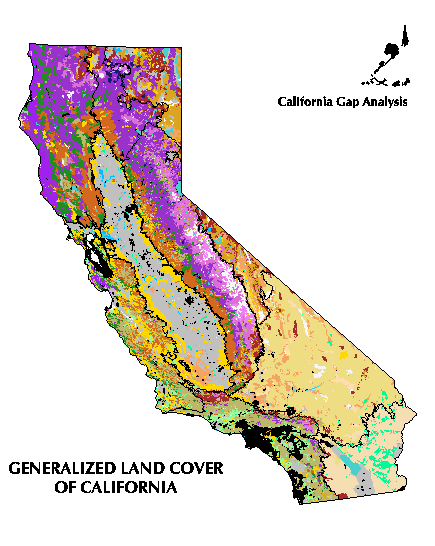
Browse Graphic File Description: Generalized color map of land
cover types of California.
Browse Graphic File Type: GIF
Raster File Sensor: n/a
Vector File Format: ARCE7 (ARC/INFO Export format, version 7)
Nonspatial File Format: n/a
II. DATA QUALITY INFORMATION
Horizontal Positional Accuracy Explanation: n/a
Vertical Positional Accuracy: n/a
Vertical Positional Accuracy Explanation: n/a
III. SPATIAL DATA ORGANIZATION INFORMATION
Raster File Column (Sample) Count: n/a
Raster File Vertical (Band) Count: n/a
Raster File Number of Bytes per Pixel: n/a
IV. SPATIAL REFERENCE INFORMATION
Units METERS
Spheroid CLARKE1866
Parameters:
1st standard parallel 34 0 0.000
2nd standard parallel 40 30 0.000
central meridian -120 0 0.00
latitude of projection's origin 0 0 0.000
false easting (meters) 0.00000
false northing (meters) -4000000.0000
V. ENTITY/ATTRIBUTE INFORMATION
Attribute
Attribute description
REGION
Jepson biophysical region of California
WHR1
Primary WHR habitat type
CROWN1
WHR canopy closure class of primary habitat type
WHR2
Secondary WHR habitat type
CROWN2
WHR canopy closure class of secondary habitat type
WHR3
Tertiary WHR habitat type
CROWN3
WHR canopy closure class of tertiary habitat type
WHRWET
Presence or absence of 9 WHR wetland habitats
CNDDB1
California Natural Diversity Data Base
("Holland") natural communities classification code of primary type
PCT1
Proportion of polygon covered by primary cover type
CNDDB2
California Natural Diversity Data Base
("Holland") natural communities classification code of secondary type
PCT2
Proportion of polygon covered by secondary cover type
CNDDB3
California Natural Diversity Data Base
("Holland") natural communities classification code of tertiary type
PCT3
Proportion of polygon covered by tertiary cover type
SP1A
Code for co-dominant species in cover type covering
the largest fraction of the polygon (primary type)
SP1B
Code for co-dominant species in primary cover type
SP1C
Code for co-dominant species in primary cover type
SP2A
Code for co-dominant species in cover type covering
the second largest fraction of the polygon (secondary type)
SP2B
Code for co-dominant species in secondary cover type
SP2C
Code for co-dominant species in secondary cover type
SP3A
Code for co-dominant species in cover type covering
the third largest fraction of the polygon (tertiary type)
SP3B
Code for co-dominant species in tertiary cover type
SP3C
Code for co-dominant species in tertiary cover type
SPWA
Code for most widespread canopy species in the wetland
portion of the polygon
SPWB
Code for second most widespread canopy species in the
wetland portion of the polygon
SPWC
Code for third most widespread canopy species in the
wetland portion of the polygon
SPSA
Code for a species of special concern either because
it is narrowly endemic, threatened or endangered that is present in the polygon
SPSB
Code for a species of special concern either because
it is narrowly endemic, threatened or endangered that is present in the polygon
Attribute
Definition Source
Regions
Hickman, 1993
Species names
Hickman, 1993
CNDDB natural community types
Holland, 1986 with additions from CA-GAP and land use
types from Anderson et al., 1976 and Cowardin et al., 1979
WHR habitat types
Mayer and Laudenslayer, 1988 amended by Interagency
Working Task Group for WHR version 5.3 (Schultze, 1994)
VI. DISTRIBUTION INFORMATION
Dr. Frank Davis
Department of Geography
University of California
Santa Barbara, CA 93106-4060
fax: 805-893-3146
e-mail: fd@geog.ucsb.edu
ftp address:
ftp://ftp.biogeog.ucsb.edu/pub/org/biogeog/data/gap_analysis
URL:
http://www.biogeog.ucsb.edu/projects/gap/gap_data.html
VII. METADATA REFERENCE INFORMATION
Metadata Standard Name: Metadata Standards for Gap Analysis
Metadata Standard Name: 09/05/1994
Metadata Review Date: n/a
Metadata Contact:
Dr. David Stoms
phone: 805-893-7655
fax: 805-893-3146
e-mail: stoms@geog.ucsb.edu
VIII. CONTACT INFORMATION
Contact Mail Address:
Department of Geography
University of California
Santa Barbara, CA 93106-4060
Contact Facsimile Telephone: (805) 893-3146
Contact Electronic Mail Address:
stoms@geog.ucsb.edu
IX. LAYER CONTENTS
Species lookup table
CNDDB community lookup table
WHR habitat lookup table
Species names
Percent classes
Crown cover classes
WHR wetland classes
CNDDB community names (and descriptions)
WHR habitat names
Start column
Attribute
Attribute parameters
Attribute description
17
REGION
3
3
C
-
Jepson region abbreviation
20
WHR1
3
3
C
-
Primary WHR habitat type
23
CROWN1
1
1
I
-
WHR canopy closure class of primary habitat type
24
WHR2
3
3
C
-
Secondary WHR habitat type
27
CROWN2
1
1
I
-
WHR canopy closure class of secondary habitat type
28
WHR3
3
3
C
-
Tertiary WHR habitat type
31
CROWN3
1
1
I
-
WHR canopy closure class of tertiary habitat type
32
WHRWET
9
9
I
-
Presence or absence of 9 WHR wetland habitats
41
CNDDB1
5
5
C
-
CNDDB natural communities classification code of
primary type (Holland, 1986)
46
PCT1
1
1
I
-
Proportion of polygon covered by primary cover type
47
CNDDB2
5
5
C
-
CNDDB natural communities classification code of
secondary type (Holland, 1986)
52
PCT2
1
1
I
-
Proportion of polygon covered by secondary cover type
53
CNDDB3
5
5
C
-
CNDDB natural communities classification code of
tertiary type (Holland, 1986)
58
PCT3
1
1
I
-
Proportion of polygon covered by tertiary cover type
59
SP1A
5
5
I
-
Co-dominant species in cover type covering the largest
fraction of the polygon (primary type)
64
SP1B
5
5
I
-
Co-dominant species in primary cover type
69
SP1C
5
5
I
-
Co-dominant species in primary cover type
74
SP2A
5
5
I
-
Co-dominant species in cover type covering the second
largest fraction of the polygon (secondary type)
79
SP2B
5
5
I
-
Co-dominant species in secondary cover type
84
SP2C
5
5
I
-
Co-dominant species in secondary cover type
89
SP3A
5
5
I
-
Co-dominant species in cover type covering the third
largest fraction of the polygon (tertiary type)
94
SP3B
5
5
I
-
Co-dominant species in tertiary cover type
99
SP3C
5
5
I
-
Co-dominant species in tertiary cover type
104
SPWA
5
5
I
-
Most widespread canopy species in the wetland portion
of the polygon
109
SPWB
5
5
I
-
Second most widespread canopy species in the wetland
portion of the polygon
114
SPWC
5
5
I
-
Third most widespread canopy species in the wetland
portion of the polygon
119
SPSA
5
5
I
-
Presence of a species of special concern either
because it is narrowly endemic, threatened or endangered
124
SPSB
5
5
I
-
Presence of a species of special concern either
because it is narrowly endemic, threatened or endangered
Start column
Attribute
Attribute parameters
Attribute description
1
SPECIES
5
5
I
-
Code for plant species
6
COMNAME
50
50
C
-
Common name of plant species
56
SCINAME
50
50
C
-
Scientific name of plant species (based on Jepson
Flora of California, Hickman, 1993)
Redefined Items
1
SP1A
5
5
I
-
1
SP1B
5
5
I
-
1
SP1C
5
5
I
-
1
SP2A
5
5
I
-
1
SP2B
5
5
I
-
1
SP2C
5
5
I
-
1
SP3A
5
5
I
-
1
SP3B
5
5
I
-
1
SP3C
5
5
I
-
1
SPWA
5
5
I
-
1
SPWB
5
5
I
-
1
SPWC
5
5
I
-
1
SPSA
5
5
I
-
1
SPSB
5
5
I
-
Start column
Attribute
Attribute parameters
Attribute description
1
CNDDB
5
5
C
-
Code for CNDDB Natural Community (Holland, 1986)
6
CNDDBNAME
50
50
C
-
Name of CNDDB Natural Community (Holland, 1986)
Redefined Items
1
CNDDB1
5
5
C
-
Code for primary CNDDB type (Holland, 1986)
1
CNDDB2
5
5
C
-
Code for secondary CNDDB type (Holland, 1986)
1
CNDDB3
5
5
C
-
Code for tertiary CNDDB type (Holland, 1986)
Start column
Attribute
Attribute parameters
Attribute description
1
WHR
3
3
C
-
Code for WHR habitat type (Mayer and Laudenslayer, 1988)
4
WHRTYPE
40
40
C
-
WHR habitat type name (Mayer and Laudenslayer, 1988)
Redefined Items
1
WHR1
3
3
C
-
Code for primary WHR type (Mayer and Laudenslayer, 1988)
1
WHR2
3
3
C
-
Code for secondary WHR type (Mayer and Laudenslayer, 1988)
1
WHR3
3
3
C
-
Code for tertiary WHR type (Mayer and Laudenslayer, 1988)
REGION
Region Name
CAS
Cascade Ranges
CW
Central Western California
ESN
East of the Sierra Nevada
GV
Great Central Valley
MOD
Modoc Plateau
MOJ
Mojave Desert
NW
Northwestern California
SN
Sierra Nevada
SON
Sonoran Desert
SW
Southwestern California NON-NATIVE VEGETATION______________________________________________
SPECIES
COMNAME
SCINAME
11100
Residential
11200
Commercial and services
11300
Industrial
11400
Transportation and Utilities
11500
Industrial and Commercial Complexes
11600
Mixed Urban
11700
Other Urban
22100
Cropland and Pasture
22101
Irrigated row and field crops
22102
Irrigated hayfield
22104
Dryland grain crops
22105
Rice fields
22106
Pasture
22200
Orchards, Vineyards, Nurseries
22201
Evergreen orchard
22202
Deciduous orchard
22203
Vineyard
22300
Confined Feeding Operations
22400
Other Agricultural Land
22500
Great Basin pasture/grainfield with remnant
bottomlands, irrigated, and/or in seepage/highwater table areas (i.e.
semiwetlands and wetlands)
Poa pratensis, Agropyron desertorum, Elyrigia
repens, Phalaris arundinacea, Carex caespitosa nebracsencsis, Deschampsia
Leymus cinereus, Hordeum jubatum, Hordeum brachyanherum, Muhlenbergia asperifolia
22600
Great Basin dry farmed grain/rural pasture
(Unirrigated, or irrigated once per year)
Agropyron desertorum, Elyrigia epens, Bromus
tectorum, Elymus elymoides
22700
Reclaimed Lakebed/Waterfowl mgmt/ag.
Scirpus acutus, Scirpus spp., Typha spp., Urtica
dioica ssp. holosericea, Phalaris arundinacea, and cultivated grains
42915
Mid-elevation plantations (most likely Ponderosa pine)
42951
Upper-elevation plantations (most likely Red fir)
55100
Streams and canals
55200
Lakes
55210
Intermittent lake
55300
Reservoirs
55310
Intermittent reservoir
55400
Bays and estuaries
77100
Dry Salt Flats
77200
Beaches
77300
Sandy areas other than beaches
77400
Bare exposed rock
77401
Bare exposed lava
77500
Quarries, and gravel pits
77600
Transitional bare areas
77700
Mixed barren land
77701
Badlands
78000
Mud Flats
99100
Perennial snowfields
99200
Glaciers
HERBACEOUS_________________________________________________________
SPECIES
COMNAME
SCINAME
31001
Non-native annual grassland
Avena spp., Bromus spp., etc.
31002
Native perennial grassland
Stipa spp., Elymus spp., etc.
31003
Estuarine emergent wetland
Salicornia virginica, Suaeda californica, etc.
31004
Coastal dune perennials
Abronia latifolia, Spartina foliosa, etc.
31005
Wet meadow Sedge - Rush
Juncus spp., Eleocharis spp.,etc.
31007
Freshwater Sedge - Rush marsh
Carex spp., Juncus, spp.,
31008
Freshwater Sedge-Cat-tail marsh
Typha spp., Carex spp., etc.
31010
Wild Mustard
Brassica ssp.
31011
Giant Reed
Arundo donax
31012
Saltgrass
Distichlis spicata
31013
Galleta
Pleuraphis rigida (formerly Hilaria rigida)
31014
Ice plant
Mesembryanthemum spp.
31015
California poppy
Eschscholtzia californica
31016
Great Basin annual grasses
Bromus tectorum, Taeniantherum caput-medusae,
Descurainia sophia, Poa bulbosa, Agropyron desertorum, Elyrigia repens, Elymus
lanceolatus, etc.
31017
Great Basin bunchgrass vegetation
Bromus tectorum, Festuca idahoensis,
Psuedoroegneria spicata, Poa secunda, Achnatherum lettermanii, Hesperostipa
comata, Achnatherum speciosum, Achnatherum occidentalis, Achnatherum
thurberiana, Elymus cinereus, Pleuraphis jamesii, Bromus carinatus var.
carinatus, Archnatherum hymenoides (1-4 species most prevalent)
31018
Great Basin Alkali sink grasses
Leymus cinereus, Bromus tectorum, Distichlis
spicata (locally dominant), Poa nevadensis, Elymus elymoides
31019
Indian ricegrass
Achnatherum hymenoides
31020
Pampas grass
Cortaderia jubata
31021
Bulrush
Scirpus robustus
31022
Rush
Juncus balticus
31023
Foxtail barley
Hordeum jubatum
31024
Nitrophila occidentalis
31025
Mules ears
Wyethia mollis
31026
Cheatgrass (exotic)
Bromus tectorum
31027
Reed canary grass (exotic)
Phalaris arundinacea
31028
Medusaehead (exotic)
Taeniantherum caput-medusae
31029
Japanese brome (exotic)
Bromus japonicus
31030
Needlegrass
Achnatherum lemmonii
31031
One-spike oatgrass
Danthonia unispicata
31032
Wood strawberry
Fragaria vesca
31033
Balsam root
Balsamorhiza sagittata
31035
Sandberg's bluegrass
Poa secunda
31036
Western needlegrass
Achnatherum occidentalis
31037
Erodium circutarium
31038
Russian thistle or tumbleweed
Salsola tragus (formerly S. kali)
31039
Corn lily
Veratrum californicum
31042
Alkali sacaton
Sporobolus airoides
31043
Carex nebrascensis
31044
Desert dandelion
Malacothrix glabrata
31045
Apricot mallow
Sphaeralcea ambigua
31046
Braken
Pteridium aquilinum
31047
Purple needlegrass
Nassella pulchra (formerly Stipa pulchra)
31048
Arizona three-awn
Aristida hamulosa
31049
Ruderal spp.
31050
California wild grape
Vitis californica
31051
Water smartweed
Polygonum amphibium
31052
Star thistle
Centaurea spp.
31054
Pitcher plant bogs
Darlingtonia bogs
31055
European beachgrass
Ammophila arenaria
31056
Erharta calycina
31057
Sphagnum bog species
Menyanthes trifoliata, Carex limosa, Sphagnum squarrosum
31058
Northern basalt vernal pool spp.
31059
Great Basin wet meadow spp.
Carex nebrascensis, Carex spp., Deschampsia
caespitosa, Juncus spp., Phalaris arundinacea
31060
Northern hardpan vernal pool spp.
31061
Northern claypan vernal pool spp.
31062
Misc. vernal pool spp.
CHAPARRAL SHRUBS___________________________________________________
SPECIES
COMNAME
SCINAME
32000
Unidentified chaparral shrubs
32001
Chamise
Adenostoma fasciculatum
32002
Tobacco brush
Ceanothus velutinus
32003
Buckbrush
Ceanothus cuneatus
32004
Greenleaf manzanita
Arctostaphylos patula
32005
Coyote brush
Baccharis pilularis
32006
Bush chinquapin
Chrysolepis sempervirens (formerly Castanopsis sempervirens)
32007
Rhododendron
Rhododendron macrophyllum
32008
Santa Cruz manzanita
Arctostaphylos andersonii
32009
Monkshood
Aconitum columbianum
32010
Currant
Ribes velutinum
32011
Mountain mahogany
Cercocarpus betuloides
32012
Bush lupine
Lupinus chamissonis
32013
Lupinus albifrons
32014
California blackberry
Rubus ursinus
32015
Blue elderberry
Sambucus mexicana
32016
Lupinus albicaulus
32017
Deerbrush
Ceanothus integerrimus
32018
Mountain whitethorn
Ceanothus cordulatus
32019
Snowdrop bush
Styrax officinalis
32020
Mountain misery
Chamaebatia foliolosa
32021
Poison oak
Toxicodendron diversilobum
32022
Yellow bush lupine
Lupinus arboreus
32023
Salal
Gaultheria shallon
32025
Eriodictyon tomentosum
32026
Redshanks
Adenostoma sparsifolium
32027
Eastwood manzanita
Arctostaphylos glandulosa
32028
Bigberry manzanita
Arctostaphylos glauca
32029
Serpentine manzanita
Arctostaphylos obispoensis
32030
Parry manzanita
Arctostaphylos parryana
32031
Purisima manzanita
Arctostaphylos purissima
32032
Woollyleaf manzanita
Arctostaphylos tomentosa
32033
Mule fat
Baccharis salicifolia (formerly B. viminea)
32034
Hoaryleaf ceanothus
Ceanothus crassifolius
32035
Desert ceanothus
Ceanothus greggii
32036
Chaparral whitethorn
Ceanothus leucodermis
32037
Bigpod ceanothus
Ceanothus megacarpus
32038
Hairy ceanothus
Ceanothus oliganthus
32039
Palmer ceanothus
Ceanothus palmeri
32040
Wartleaf ceanothus
Ceanothus papillosus
32041
Squaw carpet
Ceanothus prostratus
32042
Jimbrush
Ceanothus oliganthus var. sorediatus (formerly
Ceanothus sorediatus)
32043
Greenbark ceanothus
Ceanothus spinosus
32044
Wartystem ceanothus
Ceanothus verrucosus
32045
Virgin's bower
Clematis ligusticifolia
32046
Bush poppy
Dendromecon rigida
32047
Yerba santa
Eriodictyon californicum
32048
Thick leafed yerba santa
Eriodictyon crassifolium
32049
Fremontia or Flannel bush
Fremontodendron californicum
32050
Pale silktassel
Garrya flavescens
32051
Fremont silktassel
Garrya fremontii
32052
Veatch silktassel
Garrya veatchii
32053
Ocean spray or Cream bush
Holodiscus discolor
32054
Cream bush
Holodiscus microphyllus
32055
Refugio manzanita
Arctostaphylos refugioensis
32056
Granite gilia
Leptodactylon pungens
32058
Southern honeysuckle
Lonicera subspicata
32059
Chaparral Pea
Pickeringia montana
32060
Western choke cherry
Prunus virginiana
32061
Leather oak
Quercus durata
32062
Lemonade berry
Rhus integrifolia
32063
Laurel sumac
Malosma laurina (formerly Rhus laurina)
32064
Our lord's candle
Yucca whipplei
32065
Canyon live oak (Shrub form)
Quercus chrysolepis
32068
Interior live oak (Shrub form)
Quercus wislizenii
32069
Mexican manzanita
Arctostaphylos pungens
32070
Xylococcus bicolor
32071
Woolyleaf ceanothus
Ceanothus tomentosus
32072
Ceanothus incanus
32073
Desert scrub oak
Quercus cornelius-mullerii
32074
Sugarbush
Rhus ovata
32075
Pink-bracted manzanita
Arctostaphylos pringlei
32076
Toyon
Heteromeles arbutifolia
32077
Coffeeberry
Rhamnus californica
32078
Flowering ash
Fraxinus dipetala
32079
Prickly pear
Opuntia littoralis
32080
Hollyleaf cherry
Prunus illicifolia
32081
Snowberry
Symphoricarpos mollis
32082
Bitter cherry (Shrub form)
Prunus emarginata
32083
Giant coreopsis
Coreopsis gigantea
32084
Eriodictyon trichocalyx
32086
Mimulus aurantiacus
32087
Ceanothus impressus
32089
Ione manzanita
Arctostaphylos myrtifolia
32090
Lompoc yerba santa
Eriodictyon capitatum
32091
Peak rush-rose
Helianthemum scoparium
32092
Sulfur flower
Eriogonum umbellatum
32094
Scrub oak
Quercus berberidifolia, and other scrub oak species
32095
Ceanothus
Ceanothus spp.
32096
California broom
Lotus scoparius
32098
Prickly flox
Leptodactylon californicum
32099
Keckiella cordifolia (formerly Penstemon cordifilus) GREAT BASIN SHRUBS_________________________________________________
SPECIES
COMNAME
SCINAME
32101
Antelope bush
Purshia tridentata
32102
Rabbitbrush
Chrysothamnus nauseosus
32103
Great basin sagebrush
Artemisia tridentata
32104
Low sagebrush
Artemisia arbuscula
32105
Saltbush
Atriplex spp.
32106
Mountain mahogany
Cercocarpus ledifolius
32108
Silver sagebrush
Artemisia cana
32109
Tarragon
Artemisia dracunculus
32110
Black sagebrush
Artemisia nova
32111
Rothrock sagebrush
Artemisia rothrockii
32112
Bud sagebrush
Artemisia spinescens
32113
Four-wing saltbush
Atriplex canescens
32114
Desert holly
Atriplex hymenolytra
32115
Lenscale
Atriplex lentiformis
32116
Saltbush
Atriplex parryi
32117
Allscale saltbush
Atriplex polycarpa
32118
Rabbitbrush
Chrysothamnus parryi
32119
Rabbitbrush
Chrysothamnus viscidiflorus
32120
Brittlebush
Encelia farinosa
32121
Mormon tea
Ephedra nevadensis
32122
Green ephedra
Ephedra viridis
32123
Hopsage
Grayia spinosa
32124
Broom snakeweed
Gutierrezia sarothrae
32125
California matchweed
Gutierrezia californica
32127
Narrowleaf goldenbush
Ericameria linearifolius (formerly Haplopappus linearifolius)
32128
White burrobush
Hymenoclea salsola
32131
Scalebroom
Lepidospartum squamatum
32133
Desert almond
Prunus fasciculata
32135
Greasewood
Sarcobatus vermiculatus
32136
Mohave yucca
Yucca schidigera
32137
Desert almond
Prunus fremontii
32138
Forestiera neomexicana
32139
Ericameria
Ericameria spp. (formerly Haploppapus spp.)
32140
California ephedra
Ephedra californica
32143
Desert lavender
Hyptis emoryi
32144
Triangle leaf
Atriplex phyllostegia
32145
Menodora spinescens (formerly M. spinosa)
32147
Tetradymia axillaris
32149
Bladderpod
Isomeris arborea
32150
Suaeda moquinii (formerly S. torreyana)
32151
Regeneration shrubs
Artemisia tridentata, Chrysothamnus spp.
Purshia tridentata, Wyethia mollis DESERT SHRUBS______________________________________________________
SPECIES
COMNAME
SCINAME
32200
Unidentified desert shrubs
32201
Creosote
Larrea tridentata
32203
Buckwheat spp.
Eriogonum spp.
32202
Arroweed
Pluchea sericea
32204
Jumping cholla
Opuntia biglovii
32206
Ocotillo
Fouquieria splendens
32207
Shadscale
Atriplex confertifolia
32208
Blackbush
Coleogyne ramosissima
32209
Iodine bush
Allenrolfea occidentalis
32210
Burro-weed
Ambrosia dumosa
32212
Pencil cactus
Opuntia ramosissima
32213
Agave deserti
32214
Fagonia californica
32215
Psorothamnus emoryi (formerly Dalea emoryi)
32216
Caesalpina virgata (formerly Hoffmansegia micropylla)
32217
Golden cholla
Opuntia echinocarpa
32218
Buckhorn cholla
Opuntia acanthocarpa
32219
Barrel cactus
Ferocactus cylindraceus (formerly F. acanthodes)
32220
Tucker's Oak
Quercus john-tuckeri
32221
Crucifixion Thorn
Castela emoryi
32222
Jojoba
Simmondsia chinensis
32223
Winterfat
Krascheninnikovia lanata (formerly Eurotia lanata)
32224
Cooper's goldenbrush
Ericameria cooperi
32225
Desert wild grape
Vitus girdiana
32226
Mixed succulents
Opuntia spp., Ferocactus spp., Echinocereus spp.
32228
Nolina parryi
32229
Psorothamnus arborescens (formerly P. fremontii)
32230
Psorothamnus polydenius COASTAL SCRUB SHRUBS_______________________________________________
SPECIES
COMNAME
SCINAME
32301
California buckwheat
Eriogonum fasciculatum
32302
California sagebrush
Artemisia californica
32303
California encelia
Encelia californica
32305
White sage
Salvia apiana
32306
Purple sage
Salvia leucophylla
32307
Black sage
Salvia mellifera
32309
Ashyleaf buckwheat
Eriogonum cinerium
32310
Wright buckwheat
Eriogonum wrightii
32311
Heather goldenbush
Ericameria ericoides (formerly Haplopappus ericoides)
32316
Redberry buckthorn
Rhamnus crocea
32317
Gray horsebrush
Tetradymia canescens
32318
Pitcher sage
Salvia spathecea
32319
Hazardia squarrosa
32321
Grape soda lupine
Lupinus excubitus
32322
Eriophyllum staechadifolium
32323
Lupinus spp.
32324
Eriogonum fasciculatum var. polifolium
32325
Eriogonum fasciculatum var. fasciculatum
32326
Isocoma menziesii var. vernioides (formerly
Haplopappus venetus)
32327
Cascara
Rhamnus purshiana
32328
Craetaegus douglasii MONTANE SHRUBS_____________________________________________________
SPECIES
COMNAME
SCINAME
32401
Seviceberry
Amelanchier utahensis (formerly pallida)
32402
Manzanita
Arctostaphylos auriculata
32403
Hoary manzanita
Arctostaphylos canescens
32404
Common manzanita
Arctostaphylos manzanita
32405
Mariposa manzanita
Arctostaphylos viscida var. mariposa (formerly
Arctostaphylos mariposa)
32406
Indian manzanita
Arctostaphylos mewukka
32407
Pinemat manzanita
Arctostaphylos nevadensis
32408
Eldorado manzanita
Arctostaphylos nissenana
32409
Littleberry manzanita
Arctostaphylos nummularia
32410
La panza manzanita
Arctostaphylos pilosula
32412
Shagbark manzanita
Arctostaphylos rudis
32414
Whiteleaf manzanita
Arctostaphylos viscida var. viscida (formerly
Arctostaphylos viscida)
32415
Barbarry
Berberis nervosa
32416
Cropleaf ceanothus
Ceanothus dentatus
32417
Muskbrush
Ceanothus jepsonii
32420
Littleleaf ceanothus
Ceanothus parvifolius
32421
Monterey ceanothus
Ceanothus cuneatus var. rigidus (formerly Ceanothus rigidus)
32422
Bluebrush, Wild lilac
Ceanothus thyrsiflorus
32423
Western redbud
Cercis occidentalis
32424
Hazelnut
Corylus cornuta
32425
Scotchbroom
Cytisus scoparius
32428
Huckleberry oak
Quercus vaccinifolia
32429
Snowberry
Symphoricarpos rotundifolius (formerly vaccinoides)
32430
Huckleberry
Vaccinium ovatum
32431
Squaw or wax currant
Ribes cereum
32432
Polygonum davisiae
32433
Oregon oak (shrub form)
Quercus garryana var. breweri
32434
Goldenfleece
Ericameria arborescens
32435
Silktassel
Garrya elliptica
32438
Flat-topped buckwheat
Eriogonum deflexum
32441
Sticky currant
Ribes viscossimum
32442
Sierra gooseberry
Ribes roezlii
32443
American dogwood
Cornus sericea ssp. sericea (formerly Cornus stolonifera)
32444
Western azalea
Rhododendron occidentalis
32445
Alpine cushion plants
Misc alpine shrubs
32446
Pecho manzanita
Arctostaphylos pechoensis
32447
Morro manzanita
Arctostaphylos morroensis
32448
Elderberry spp.
Sambucus spp.
32449
Red elderberry
Sambucus racemosa
32450
Vine maple
Acer circinatum
32451
Manzanita spp.
Arctostaphylos spp.
32452
Boxleaf silktassel
Garrya buxifolia
32453
Swordfern
Polystichum munitum
32454
Beargrass
Xerophyllum tanex
32455
Saddler's oak
Quercus sadleriana
32456
Hairy manzanita
Arctostaphylos columbiana
32457
Thimbleberry
Rubus parviflorus OTHER SHRUBS_______________________________________________________
SPECIES
COMNAME
SCINAME
32501
Skunkbrush
Rhus trilobata
32502
Goldenbush
Ericameria bloomeri (formerly Happlopappus b. and
Chrysothamnus b.)
32503
Wood rose
Rosa gymnocarpa
32504
Fern bush, desert sweet
Chamaebatiaria millefolium
32507
Desert sage
Salvia dorrii
32509
Ribes aureum
32510
Desert peach
Prunus andersonii
32511
Ribes spp. HARDWOOD TREES_____________________________________________________
SPECIES
COMNAME
SCINAME
41001
Black oak
Quercus kelloggii
41002
Blue oak
Quercus douglasii
41003
Canyon live oak
Quercus chrysolepis
41004
Coast live oak
Quercus agrifolia
41005
Interior live oak
Quercus wislizenii
41006
Oregon oak
Quercus garryana
41007
Madrone
Arbutus menziesii
41008
Red alder
Alnus rubra
41009
Quaking aspen
Populus tremuloides
41010
Black cottonwood
Populus balsamifera ssp. trichocarpa (formerly
Populus trichocarpa)
41011
California bay
Umbellularia californica
41012
Fremont cottonwood
Populus fremontii
41013
Valley oak
Quercus lobata
41014
White alder
Alnus rhombifolia
41015
Willow
Salix spp.
41016
Catclaw
Acacia greggii
41017
Desert ironwood
Olneya tesota
41018
Joshua tree
Yucca brevifolia
41019
Mesquite
Prosopis glandulosa
41020
Fan palm
Washingtonia filifera
41021
Palo verde
Cercidium floridum
41022
Smoke tree
Psorothamnus spinosa (formerly Dalea spinosa)
41023
Tamarisk
Tamarix spp.
41026
Buckeye
Aesculus californica
41027
Engelmann oak
Quercus engelmannii
41029
Sycamore
Platanus racemosa
41030
Eucalyptus
Eucalyptus spp.
41032
California walnut
Juglans californica var. californica (formerly
Juglans californica)
41033
Box elder
Acer negundo
41036
Golden chinquapin
Chrysolepis chrysophylla (formerly Castanopsis chrysophylla)
41037
Desert willow
Chilopsis linearis
41040
Oregon ash
Fraxinus latifolia
41043
California black walnut
Juglans californica var. hindsii (formerly Juglans hindsii)
41044
Tanoak
Lithocarpus densiflorus
41045
Tree tobacco
Nicotiana glauca
41049
Bitter cherry
Prunus emarginata
41050
Bigleaf maple
Acer macrophyllum
41051
Screwbean
Prosopis pubescens
41052
Mountain alder
Alnus incana var. tenuifolia (formerly Alnus tenuifolia)
41053
Mountain maple
Acer glabrum
41054
Water Birch
Betula occidentalis
41055
Quercus alvordiana
41056
California wax myrtle
Myrica californica
41057
Pacific dogwood
Cornus nuttallii
41059
Tree of heaven
Ailanthus altissima
41060
Black locust
Robinia pseudoacacia CONIFER TREES______________________________________________________
SPECIES
COMNAME
SCINAME
42003
Coast redwood
Sequoia sempervirens
42005
Douglas fir
Pseudotsuga menziesii
42006
Grand fir
Abies grandis
42007
Bigcone spruce
Pseudotsuga macrocarpa
42009
Sitka spruce
Picea sitchensis
42010
Bishop pine
Pinus muricata
42011
Foxtail pine
Pinus balfouriana
42012
Jeffrey pine
Pinus jeffreyi
42013
Knobcone pine
Pinus attenuata
42014
Lodgepole pine
Pinus contorta var. murrayana
42015
Ponderosa pine
Pinus ponderosa
42016
MacNab cypress
Cupressus macnabiana
42017
Mountain hemlock
Tsuga mertensiana
42018
Baker cypress
Cupressus bakeri
42019
California juniper
Juniperus californica
42022
White fir
Abies concolor
42026
Whitebark pine
Pinus albicaulis
42027
Giant sequoia
Sequoiadendron giganteum
42028
Bristlecone pine
Pinus longaeva (formerly Pinus aristata)
42029
Limber pine
Pinus flexilis
42030
Single leaf pinyon
Pinus monophylla
42031
Western white pine
Pinus monticola
42032
Piute cypress
Cupressus arizonica ssp. nevadensis
42033
Bristlecone fir
Abies bracteata
42034
Coulter pine
Pinus coulteri
42035
Monterey pine
Pinus radiata
42036
Gowen cypress
Cupressus goveniana
42037
Monterey cypress
Cupressus macrocarpa
42039
Sargent cypress
Cupressus sargentii
42040
Torrey pine
Pinus torreyana
42041
Cuyamaca cypress
Cupressus arizonica ssp. arizonica (formerly C. stephensonii)
42042
Tecate cypress
Cupressus forbesii
42043
Brewer spruce
Picea breweriana
42044
Foothill pine
Pinus sabiniana
42045
Incense cedar
Calocedrus decurrens (formerly Libocedrus decurrens)
42046
Noble fir
Abies procera
42048
Pacific yew
Taxus brevifolia
42049
Parry pinyon
Pinus quadrifolia
42050
Port Orford cedar
Cupressus lawsoniana (formerly Chamaecyparis lawsoniana)
42051
Red fir
Abies magnifica
42052
Subalpine fir
Abies lasiocarpa
42053
Sugar pine
Pinus lambertiana
42054
Utah juniper
Juniperus osteosperma
42055
Western juniper
Juniperus occidentalis
42057
Washoe Pine
Pinus washoensis
42058
Western hemlock
Tsuga heterophylla
42059
Shore pine
Pinus contorta var. contorta
42061
Pygmy cypress
Cupressus goveniana ssp. pigmaea
42062
Western red cedar
Thuja plicata
42063
Sierra juniper
Juniperus occidentalis australis
PCT1/2/3
Description
1
10-20 %
2
20-30 %
3
30-40 %
4
40-50 %
5
50-60 %
6
60-70 %
7
70-80 %
8
80-90 %
9
90-100 %
CROWN1/2/3
Description
1
10-24 % cover
2
25-39 %
3
40-59 %
4
60-100 %
CROWN1/2/3
Description
1
2-9 %
2
10-39 %
3
40-59 %
4
60-100 %
Column
WHR Wetland Type
1
Montane Riparian (MRI)
2
Valley-Foothill Riparian (VRI)
3
Desert Riparian (DRI)
4
Wet Meadow (WTM)
5
Freshwater Emergent Wetland (FEW)
6
Saline Emergent Wetland (SEW)
7
Riverine (RIV)
8
Lacustrine (LAC)
9
Estuarine (EST)
Code
Description
0
no data available
1
wetland type is absent
2
wetland type is present
WHR1/2/3
WHR Habitat Type
ADS
Alpine-Dwarf Shrub
AGS
Annual Grassland
ASC
Alkali Desert Scrub
ASP
Aspen
BAR
Barren
BBR
Bitterbrush
BOP
Blue Oak-Foothill Pine
BOW
Blue Oak Woodland
COW
Coastal Oak Woodland
CPC
Closed-Cone Pine-Cypress
CRC
Chamise-Redshank Chaparral
CRP
Cropland
CSC
Coastal Scrub
DFR
Douglas-Fir
DGR
Dryland Grain Crops
DOR
Deciduous Orchard
DRI
Desert Riparian
DSC
Desert Scrub
DSS
Desert Succulent Shrub
DSW
Desert Wash
EOR
Evergreen Orchard
EPN
Eastside Pine
EST
Estuarine
EUC
Eucalyptus
FEW
Freshwater Emergent Wetland
IGR
Irrigated Grain Crops
IRF
Irrigated Row and Field Crops
IRH
Irrigated Hayfield
JPN
Jeffrey Pine
JST
Joshua Tree
JUN
Juniper
KMC
Klamath Mixed Conifer
LAC
Lacustrine
LPN
Lodgepole Pine
LSG
Low Sage
MCH
Mixed Chaparral
MCP
Montane Chaparral
MHC
Montane Hardwood-Conifer
MHW
Montane Hardwood
MRI
Montane Riparian
OVN
Orchard and Vineyard
PAS
Pasture
PGS
Perennial Grassland
PJN
Pinyon-Juniper
POS
Palm Oasis
PPN
Ponderosa Pine
RDW
Redwood
RFR
Red Fir
RIC
Rice
RIV
Riverine
SCN
Subalpine Conifer
SEW
Saline Emergent Wetland
SGB
Sagebrush
SMC
Sierran Mixed Conifer
URB
Urban
VIN
Vineyard
VOW
Valley Oak Woodland
VRI
Valley-Foothill Riparian
WFR
White Fir
WTM
Wet Meadow
XXX
No secondary or tertiary WHR type