

What's New
Research & Projects Publications
People
Data
Links
Applying the MCLP Model to Select Reserves: Using the Arc/Info GIS
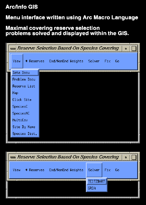
The focus of this research activity under the IBM ERP was to take operations research techniques that were well known in the literature on facility location, and to apply them to optimal reserve selection. The model utilized was the Maximal Covering Location Problem (MCLP). The application of the MCLP to selecting reserves has been outlined by Church, Stoms, and Davis (1996) in Biological Conservation. The difference between the Church et al. application and this research was that this application of the MCLP to reserve siting was carried out entirely within the Arc/Info Geographical Information System. ESRI has recently debuted a location modeling capability as a resident tool within the Arc/Info system.
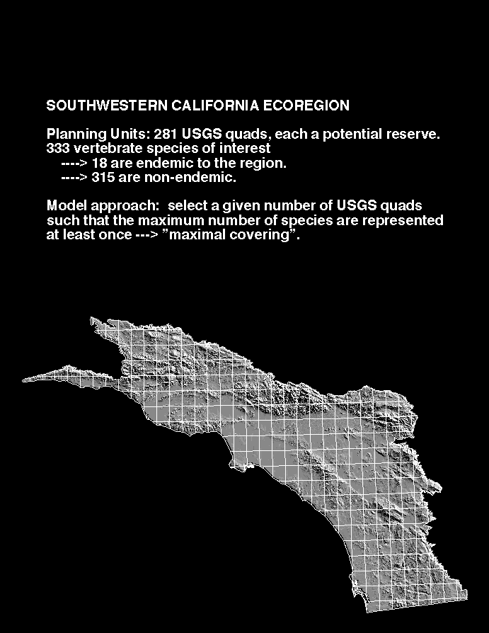
Here is demonstrated a sample application of selecting natural reserves from among 281 USGS quadrangles in the Southwestern California Ecoregion. From among these candidate quadrangles, we seek the set of p quads (where p may vary from 1 to 12 or 13) such that the greatest number of species is present in at least one of the selected reserves. In this case, the species are a set of 333 vertebrates of interest. Each candidate quadrangle has a list of species that are found within it, this list being determined by various data such as estimates of suitable breeding habitat. As would be expected, the urbanized quads of the Los Angeles basin are far less rich in species than the mountainous, relatively undeveloped quads around the fringe of the area.
To facilitate the GIS application, Arc Macro Language was used to automate all necessary functions and to construct a pull down menu interface. The SW Ecoregion of California, with USGS 100-meter digital elevation model and quadrangle outlines, is shown here. This is the same data set utilized by Church, Stoms, and Davis (1996).
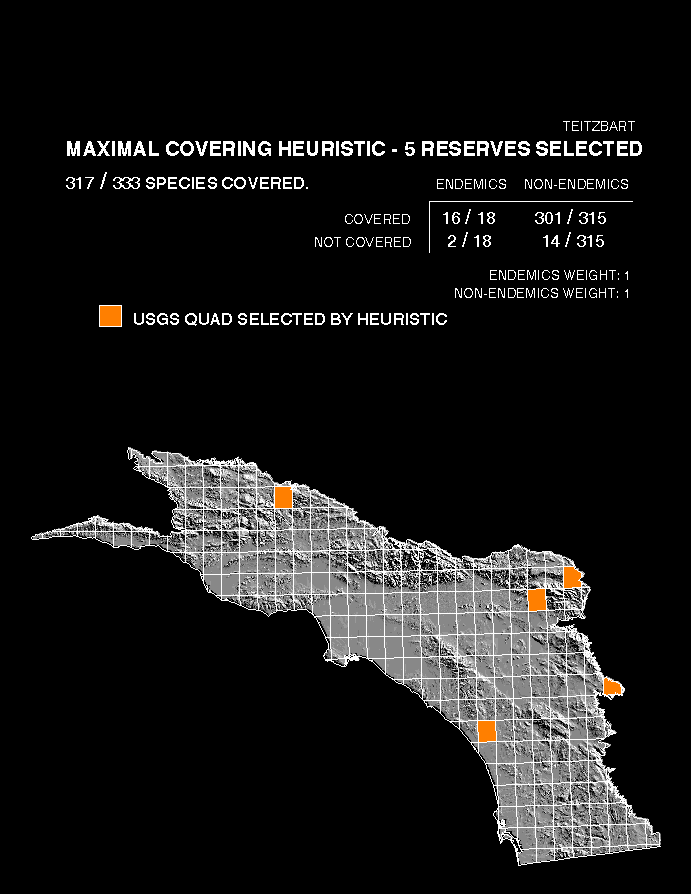
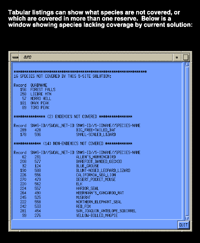
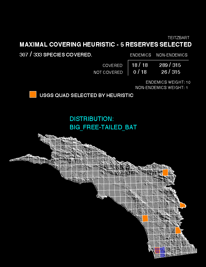
A sample solution selects 5 reserves using as a solution method the interchange heuristic of Teitz and Bart ("GRIA" is the other, somewhat similar, heuristic that can be called up from Arc/Info. It should be noted that the solution heuristics used by Arc/Info do not guarantee that any result is truly optimal. In contrast, Church et al. (1996) used techniques (exterior to any commercial GIS) that did guarantee an optimal result for each attempted solution). In this case, endemics and nonendemics receive equal preference. As can be seen from the graphic, this solution covers 317 out of 333 species. Two endemics do not receive coverage. Here is an example of tabular output that can be generated by the system. It is a listing of the 16 species not covered by the solution. Note that the Big Free Tailed Bat and Small Scaled Lizard are not covered in the reserve system.
Here is an example of alternatives generation. We may decide that it is unacceptable to leave 2 endemics without protection. Therefore, instead of the "maximal covering" solution, we want to investigate a "weighted maximal covering" solution in which we stress designing our reserve system such that every endemic is covered, if possible. Thus, we run the identical problem except that we put a higher weight on covering endemics. In this case, we make each endemic worth 10 times a nonendemic (this is not meant to be a value judgment on the relative importance of endemics and nonendemics but a mathematical tool that "steers" the solution toward covering all endemics that it can). The results: We succeed in including every endemic species in our 5-site reserve system. As a graphical confirmation that one previously uncovered endemic, the Big Free Tailed Bat, is now covered, we overlay the spatial distribution of the Big Free Tailed Bat over the reserve system. We see that one of the 3 quads near San Diego that contain the Bat (in this case the National City quad) is part of the reserve system. The price we pay for this is to reduce overall species coverage to 307, down from 317 previously.