

What's New
Research & Projects Publications
People
Data
Links
8. MANAGEMENT IMPLICATIONS AND FUTURE DIRECTIONS
Preliminary Site Ranking
Gap Analysis and State or Regional Biodiversity Planning
Future Directions for Gap Analysis in California
Preliminary Site RankingGap analysis is designed to identify conservation priorities among the set of ecosystems or plant communities, but it does not automatically imply to a distinct set of priority places. Many techniques have been proposed in the conservation literature for meeting various conservation goals. There is no consensus about the best approach, however. Here we use a simplified scoring approach to rank 7.5 minute quadrangles in California and identify some locations that appear worthy of further investigation. Quadrangles are obviously not ecologically defined land units nor are they useful as potential managed area boundaries. Nevertheless, they provide a set of equal sized planning units that are of a scale appropriate to regional conservation planning.
Two criteria were used to rate each quadrangle:
� the relative abundance of plant communities and their conservation priority (from chapter 7)
� an index of site suitability for biodiversity management
Each criterion is composed of multiple factors, and all factors and criteria are weighted by our judgment of their relative importance.
In chapter 7, we ranked plant communities by their conservation importance based on the coarse-filter of gap analysis. The area of each grouping (Table 7-1) was summed for each quadrangle and then weighted (Table 8-1) to calculate a site score. The area of lands already designated as management classes 1 or 2 were excluded from the site scoring because their contribution was already considered in the vulnerability ratings of plant communities. Sites with large proportions of highly vulnerable communities outside of existing managed areas score highest while those with well-represented communities or human land uses would score close to zero.
Priority Group
% Status 1 and 2
Threat Index
Weight
A
< 20
�
1.0
B
>20
�
0.75
C
�
high
0.75
D
<10
low
0.5
E
10-20
low
0.3
F
20-50
low
0.1
G
>50
low
0.0
H (non-vegetated)
�
�
0.0
Table 8-1. Weighting for plant communities by priority group.
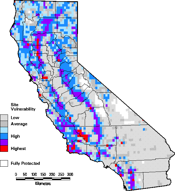
The map of site scores is shown in Figure 8-1. The highest scoring quadrangles tend to occur in a ring around the Great Central Valley, particularly in western Kern County, and in Glenn, Colusa, and Tehama counties. Western Santa Barbara County and Solano County contain other particularly high scoring clusters of quadrangles. Other relatively high scoring areas include the Sierra Nevada foothills, much of the Central Western region, parts of Shasta County, undeveloped areas throughout the Southwestern California region, and a small area along the border with Nevada in Lassen County. Low scoring sites occur throughout the Great Central Valley, Los Angeles Basin, and the Imperial Valley near the Mexican border where agriculture or urbanization have eliminated most of the native vegetation. Other low scoring areas occur in the higher elevations of the southern Sierra Nevada and the majority of the Mojave and Sonoran Desert regions where the plant communities are well-represented in managed areas and thus tend to have low priority. Readers should note that a quadrangle could have a low score and yet contain a rare community type that only occurs at that site. Such a site would be "irreplaceable" (Pressey et al. 1994) but its importance is not reflected in the score.
Figure 8-1. Site scoring for plant communities by quadrangle.
Gap Analysis and State or Regional Biodiversity Planning
We view conservation planning as a complex process by which society develops rational strategies for sustainable use and conservation of natural resources. We believe that such strategies must engage all sectors of society and must address multiple levels of social and biological patterns and processes over local to regional, continental, and even global extents. One important outcome of such planning is the prioritization of biota and areas for expanded protection and/or conservation management. (An equivalent but complementary view is that conservation planning reveals where consumption and conversion of natural resources to accommodate population growth and economic development can proceed with the least threat to biodiversity.)
There is not necessarily a clear distinction between nature reserves versus areas that are managed for sustainable resource harvest, and it may be more useful to think of a management gradient which at one extreme involves intensive management to maximize economic yield (e.g., creation and sustainable harvest of timber plantations or improved pastures) and at the other may involve intensive management to maintain or restore native species or ecosystem processes (e.g., tree planting and streamflow manipulation to restore riparian habitats). While the answers to these questions should be guided by scientific knowledge, ultimately they reflect the values of those who pose them (Noss 1996). Gap analysis provides the information necessary for the process of setting credible conservation goals by identifying the gaps in the current conservation network.
The second stage of conservation planning, site selection, is generally undertaken using relatively coarse survey information (e.g., Noss 1987, Scott et al. 1993), whereas the reserve design stage requires very detailed analyses of the biotic composition, size, shape, connectedness, and cost of alternative reserve plans (Shafer 1990). Management practices allowed in reserves must be based upon an understanding of the impacts of various land uses and natural disturbances on the viability of the biota and will be highly case-specific (Noss 1996).
Gap analysis serves as a coarse-filter for a preliminary inventory of plant communities and wildlife species and rates their relative vulnerability in regard to land management (Scott et al. 1993). Beyond the initial conservation assessment, these findings can be applied in at least two additional directions. First they provide a regional perspective on biodiversity distribution, management, and conservation priorities that provides a broader context for assessing the impacts of local land use proposals. GAP data can quantify how rare a community type is, where else it occurs, and whether it is well-represented in biodiversity management areas. Second, the data from GAP can play a significant role in follow-up conservation planning efforts at a statewide or regional level (Crowe 1996, Vickerman 1996). For instance, GAP data can provide the missing biodiversity dimension to discussions about alternative wilderness and national park proposals (Wright et al. 1994, Merrill et al. 1995, Merrill et al. 1996, Wright and Scott 1996). The Nature Conservancy has already used a small portion of the CA-GAP database to identify candidate areas to ensure adequate representation of all community types in the Columbia Plateau ecoregion (Stoms et al. 1997). The Southern California Association of Governments used CA-GAP data in conjunction with general plans from a six county area to identify priorities for conservation of plant communities in the open space element of their comprehensive regional plan (Crowe 1996). Figure SW-4 shows the pattern of communities considered vulnerable in gap analysis for the Southwestern California region overlaid with areas zoned for development or agriculture in existing general plans of local jurisdictions.
Gap analysis findings have already been used in research studies to develop tools to select areas for additional biodiversity management (Church et al. 1996, Davis et al. 1996, Stoms et al. 1997). Moritz et al. (1997) demonstrated the use of CA-GAP data to screen potential sites for Research Natural Areas for the U. S. Forest Service. These approaches often include additional data layers on stress factors (e.g., human population density and roadedness) and relative manageability of sites (e.g., private ownership, fragmentation of ownership) as well as the biological distribution and status data. Although considerable progress is being made in developing these tools, our limited understanding of the requirements of most species and ecosystems hinders our efforts to create computer models adequate to the task. These site selection studies were not part of the initial state gap analysis, but are areas of active research being pursued by the National GAP and others.
Future Directions for Gap Analysis in California
The USGS-BRD Gap Analysis Program has effectively translated the general principles of the gap analysis method into a pragmatic, operational approach for assessing the regional distribution and management status of plant communities and vertebrate species. However, embedded within the GAP methodology are a number of assumptions that still need to be tested in order to strengthen the program's credibility and to refine the approach. For example, it is generally assumed that the mapping of communities and vertebrates is sufficiently detailed and accurate to meet GAP objectives, that general vegetation types and vertebrates adequately represent biodiversity in general, and that the four classes of land management status mapped in gap analysis accurately portray the distribution of human activities that determine biotic vulnerability. While each of these assumptions need to be tested, we feel that the last is of critical importance to the utility of GAP. We have proposed that the current approach to measuring vulnerability can be usefully improved upon by incorporating more information about permitted land management practices, and linking that information to expected biotic responses to those activities. We initially began exploring some of these ideas last year as part of our work for the Sierra Nevada Ecosystem Project. We are requesting funds to continue this research effort with a set of theoretical studies and empirical analyses using data from California. The potential benefits of this research are threefold: 1) to provide a more formal definition of vulnerability (which is absent in the GAP symposium book glossary), 2) to test the assumption that GAP management classes can predict vulnerability, and, 3) to test the utility of additional mappable factors, the spatial context of managed areas, and biotic responses to land management that could lead to improved predictions of biotic vulnerability.
Other directions are more specific to CA-GAP. The classification of land-cover types used in this report (Holland 1986) has been widely used in California, but it does not fully comply with recent federal vegetation classification standards (Federal Geographic Data Committee 1996). The California Native Plant Society (CNPS) has also published a new classification of floristically based "series" (Sawyer and Keeler-Wolf 1995) which we have not integrated into the CA-GAP database. This new classification was designed with the federal standards in mind, although the federal system is more structurally based. Many state and federal agencies have now adopted the CNPS classification as a new standard for California (Keeler-Wolf and Barbour 1997). Future updating of the database must accommodate whatever classification scheme is in place at that time. The current database contains information on dominant canopy plant species, which should facilitate any reinterpretation of the data into a new set of alliances without remapping.
Another major limitation of the current CA-GAP database is that neither the land-cover nor the predicted vertebrate distributions have been formally validated. Most assessment to date has been comparison of GAP data with published or compiled lists of biodiversity elements for sets of managed areas.
The California Department of Fish and Game is assuming responsibility for management of the CA-GAP database upon completion of this initial gap analysis. Potential database users are directed to Fish and Game for products and support.
Page last updated 06/09/2004 21:34:18
CA-GAP Home | Overview | Report | Download GIS | CD-ROM | Site Index | National GAPTop of Page Send your comments to: stoms@geog.ucsb.edu
UCSB Biogeography Lab Home