

What's New
Research & Projects Publications
People
Data
Links
EXECUTIVE SUMMARY
THE CALIFORNIA GAP ANALYSIS PROJECT
Report Date: 30 June 1998
CA-GAP Database Development
Assessment of the Management Status of Biodiversity
Conservation Priorities
CA-GAP Database Uses and Availability
The California Gap Analysis Project (CA-GAP) was initiated in 1990 as a cooperative effort between the U.S. Fish and Wildlife Service and researchers at the University of California, Santa Barbara. Dozens of public and private organizations also provided invaluable support. The objectives of the project were to 1) develop new geographic information system (GIS) databases of land-cover, wildlife habitats, predicted distributions of native wildlife species, and land stewardship and management; 2) identify land-cover types and wildlife species that are inadequately represented in existing biodiversity management areas (i.e., the "gaps"); and 3) make all CA-GAP information available to users to encourage and facilitate its use so that resource managers may be more effective stewards of California's biological heritage.
CA-GAP Database DevelopmentLand Cover
CA-GAP compiled the first new medium-resolution map of actual land-cover of California since 1980. This land-cover map was produced using summer 1990 Landsat Thematic Mapper satellite imagery, 1990 high altitude color infra-red photography, the Vegetation Type Maps based on field surveys conducted between 1928 and 1940, miscellaneous recent vegetation maps, and ground surveys. Initial landscape boundaries were drawn by manual photointerpretation of the satellite imagery. The minimum mapping unit for upland land-cover was 100 ha and 40 ha for wetlands. Median map unit size is 528 ha. The final land-cover map includes distribution information on 194 natural plant community types and 27 land use classes, plus 96 dominant species of trees and 237 shrub species. A formal accuracy assessment of this map has not been conducted, but initial comparisons indicate that the map is in close agreement with other, recent vegetation maps.
Vertebrates
Distributions of 455 native vertebrate species were predicted by GIS modeling. Species range limits and habitat suitability ratings came from the California Wildlife Habitat Relationships System, while the distribution of habitat types was derived from the CA-GAP land-cover map. The predicted distribution database rates each mapped landscape polygon on the basis of the suitability of the individual habitat types it contains and their relative abundance. Thus a highly rated polygon would have >50% of its area in high suitability habitat. The maps, therefore, categorize the habitat of all map units on a scale from 0-5 rather than dividing the state into suitable and unsuitable habitat. Accuracy assessment on the predicted vertebrate distributions are underway but were not completed at the date of this report.
Land Ownership and Management
To determine how well species and plant communities are currently protected, CA-GAP enhanced the 1:100,000 scale land ownership map maintained by the California Teale Data Center by adding boundaries of special managed areas not in the original ownership map, incorporating recent acquisitions, and classifying all lands by management status. This classification uses a scale from 1 to 4 to denote the relative degree of management for biodiversity, with "1" being the highest, most permanent level and "4" being the least secure. The status level was assigned based on the management intent of the land steward as expressed in general policies or legislation. Generally all private lands were assigned to status level 4 because long-term management of individual tracts is unknown.
Roughly 15% of California is currently managed as status 1, with an additional 3% in status 2. Just over half of the state is in status 4 management, most of which is privately owned. The remaining 30% is other public lands managed by agencies such as the U.S. Forest Service and the Bureau of Land Management and not otherwise designated for biodiversity management. Most of the 741 status 1 and 2 managed areas are quite small, with a median size of only around 800 ha. Although the proportion of protected area in California is relatively high compared to other regions, the distribution is highly biased towards certain geographic and topographic locations. The majority of status 1 and 2 lands are in the southern Sierra Nevada and in the Mojave and Sonoran Desert regions (especially following passage of the California Desert Protection Act of 1994). Low elevations, particularly along the coast and in the Great Central Valley are strikingly under-represented.
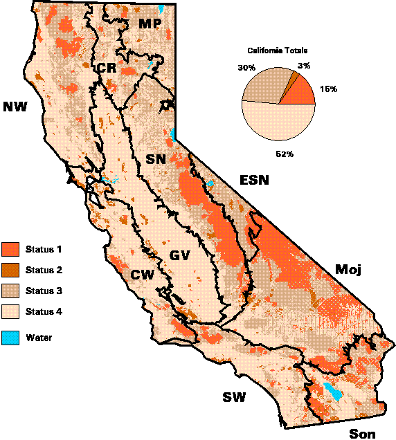
Figure 1. Management status of lands in California.
Assessment of the Management Status of Biodiversity
Land Cover
Of the entire state, 13% has been converted to agricultural uses, nearly 5% to urbanization, 3% is unvegetated, and 79% remains vegetated with natural communities. As there is no concensus on a definition of "adequate representation," a pratical solution is to report the percentages of each community type in status 1 and 2 areas and allow the user to determine which types they believe need additional conservation. Of the 194 community types mapped by CA-GAP, 73 have less than 10% representation, 46 types have between 10 and 20%, 44 have between 20 and 50%, and 31 have more than 50%. The types with less than 10% representation generally fall within several categories: coastal scrub, Great Basin scrub, prairie grasslands, hardwood woodlands, and a few conifer forests. The types that are best represented are communities characteristic of Mojave Desert scrub or subalpine conifer and alpine communities (Figure 2).
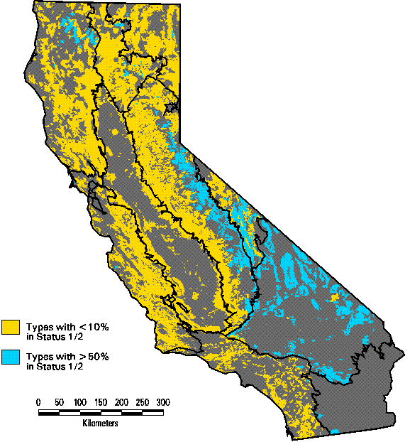
Figure 2. Plant communities that are least- and best-represented in managed areas in California.
Coastal scrub types are of great concern both because they are often prime land for urbanization along California's coastal plains and large proportions of their historical extent has already been converted. As a result, they harbor a large percentage of the state's threatened and endangered plant and animal species. Native grasslands have been similarly affected through conversion to agriculture, invasion by exotic Old World annual plants, and change in fire regime, so that all are considered highly threatened. Most hardwood types occur principally on private lands and are subject to a number of impacts such as grazing, fuelwood cutting, clearing for pasture or cultivation, and fire suppression. Several oak species, notably Valley oak (Quercus lobata), Blue oak (Q. douglasii), and Engelmann oak (Q. engelmannii), have exhibited low rates of recruitment in recent decades, adding to the concern about the long-term viability of these ecosystems. The under-represented conifer types tend to contain the most commercially valuable timber species such as redwoods, ponderosa pine, and douglas-fir. Even though these types have not been extensively converted to other uses, they have been heavily altered in composition or structure either by selective removal of favored species (e.g., sugar pine) and/or great reduction in the extent of late successional stands.
Forty-six types were found to have between 10-20% representation in GAP status 1 and 2. Many of these are chaparral types which in general were assigned low levels of threat in the NHD rankings. These tend to occur in steep terrain with few resource conflicts. The primary issue in preserving chaparral is fire management.
Also in the 10-20% group are some of the riparian forest types, most of which are considered threatened or very threatened in the NHD rankings. Several of the saltbush or sink scrub communities also are in this category. All are considered threatened by NHD due to past losses from irrigated agriculture and the accidental flooding of the Salton Basin at the beginning of the century.
Forty-four cover types have 20-50% representation in GAP status 1 and 2. Most of these types are from the deserts, marshes, and the upper conifer forest zone. Included here are the creosote scrub communities of both the Sonoran and Mojave deserts, Alkali Playas, Desert Dry Wash Woodland, Desert Sink Scrub, and Mojavean Pinyon and Juniper Woodland. The montane types include communities such as Big Tree, Jeffrey Pine and Red Fir Forests, Huckleberry Oak Chaparral, Canyon Live Oak Forest, and meadows. Most of these types are not considered threatened in the NHD rankings, but there are several notable exceptions such as Desert Sink Scrub, Valley Needlegrass Grassland, Sitka Spruce-Grand Fir Forest, Beach Pine and Bishop Pine Forests, Siskiyou Enriched Coniferous Forest, and the wetland types.
Thirty-one types out of the 194 that were mapped have over half of their distribution in status 1 or 2 managed areas. Of these, 8 were mapped over less than 25 km². Two types (Northern Coastal Bluff Scrub and Santa Lucia Fir Forest) occur entirely within protected areas. The majority of types in this category are Mojave Desert scrub or subalpine conifer forests and alpine communities, corresponding to the areas where protected areas are most concentrated. The remaining types tend to be rather rare or highly localized and often the focus of conservation action. Examples of this are the Salmon-Scott Enriched Coniferous Forest, Port Orford Cedar, and Valley Sacaton Grassland. The latter is ranked as very threatened by the Natural Heritage Division (NHD) of the California Department of Fish and Game and has suffered extensive reductions from agricultural land uses. Some of the few remaining stands have been recently acquired by the California Department of Parks and Recreation, but additional management action may still be required to preserve this type.
Vertebrates
For this gap analysis, we limited the predicted distributions of terrestrial vertebrates to habitats within each species range that were rated as 4 or 5, i.e., most of the land-cover/habitat polygon was classified as moderate to high suitability. Several species have very low levels of representation (<5 %) in managed areas. These species fall into four general groupings:
- adapted to human-dominated habitats
(little or no action needed)Inca dove
Bronzed cowbird
Black phoebe
Western kingbird
American crow
Red-winged blackbird
Hooded oriole
American goldfinch
Woodhouses toad
Black- and Yellow-billed magpies (commonly feed in agricultural habitats but also depend on riparian or oak woodland habitat for breeding and cover)
- very limited ranges
(very narrowly endemic species are best evaluated in a "fine-filter" approach to complement the "coarse-filter" gap analysis)Townsends pocket gopher (subspecies found in California is restricted to the Honey Lake area in Lassen County)
White-footed vole
Fresno (or San Joaquin) kangaroo rat
Tiger salamander
Redbelly newt
Siskiyou Mountains salamander
Shasta salamander
Spotted frog (may, in fact, have never occurred in California; may be misidentified specimens)
Grasshopper sparrow (wider range than these other species, but its abundance is erratic from year-to-year)
- marginal to the state
(should be re-assessed in ecoregional gap analyses over their entire range)Gila woodpecker
Cordilleran flycatcher
Cedar waxwing
Northern pocket gopher
Pronghorn
Short-horned lizard (most widely distributed lizard in North America but in California only occurs in the Modoc Plateau region at the margin of its range)
- diminishing or degraded habitats
(generally the most vulnerable group of species)Swainsons hawk
Black-chinned hummingbird
California kangaroo rat
Western spadefoot
Of all native vertebrates, the largest group has 10-20 % of their predicted distributions in managed areas, with about equal numbers with <10 and 20-50 % (Table 1). Very few species have >50 % protection and these tend to be species with very small ranges, such as the Alpine chipmuck (Tamias amoenus), which was predicted over only 444 km², or <0.1% of Californias land area, in the rocky habitats above 2800 m in the High Sierra.
Table 1. Summary of species at different levels of biodiversity management.
# (%) with < 10% Status 1/2
# (%) with 10-20% Status 1/2
# (%) with 20-50% Status 1/2
# (%) with > 50% Status 1/2
Total # of species
Land Birds
72 (35%)
83 (41%)
44 (22%)
5 (2%)
204
Mammals
30 (23%)
52 (39%)
40 (30%)
11 (8%)
133
Amphibians
18 (44%)
14 (34%)
7 (17%)
2 (5%)
41
Reptiles
10 (14%)
21 (30%)
35 (49%)
5 (7%)
71
All Native Vertebrates
130 (29%)
170 (38%)
126 (28%)
23 (5%)
449
As a group, reptiles appear to be the best protected according to their management status. More than half of the 71 reptiles have >20 % status 1 and 2 habitats. Only 10 reptiles have <10 % in managed areas. This high level of protection for this group is explained not so much because conservation action has focused on them but rather by an extensive set of parks and wilderness areas designated in the California deserts where most of the reptiles reside. Amphibians are the least well-represented group in managed areas. The largest category of amphibians has <10 % status 1 and 2. Only 9 amphibians (22 %) have >20 % protection.
CA-GAP predicted species distributions on the basis of range boundaries and the suitability of habitat types with the range. It does not guarantee that a species will occur at all locations that are modeled as suitable habitat. For some species, there are additional habitat elements that further control their distribution. Elements such as the presence of snags, proximity to surface water, or the adjacency of different critical habitat types, for example, are site-specific features that can not be detected at a regional scale with remotely sensed data. Habitat structure is also a crucial factor in determining habitat suitability for many species. Structure would characterize the height of the canopy, the density of canopy cover, and the number of layers in the canopy in multi-storied, uneven-aged habitats. Those species that are dependent on either these key habitat elements or on specific seral stages are likely to be grossly overestimated by our modeling methods. Species such as the California spotted owl and the fisher require mature stands of dense forest. This level of detail was also not compiled for CA-GAP, so suitability was based only on the type of habitat, not its structure.
Conservation Priorities
Priority Community Types
Within the set of plant communities, we distinguished seven categories (Table 2). The first two categories include all those rated as rare by the NHD (S1 or S2). Of these, the highest priority (Group A) is for rare communities with less than 20% level of status 1 and 2 management, while the second priority types have more than 20% (Group B).
Priority Group
Rarity
% Status 1 and 2
Threat Index
Weight
A
Rare
< 20
1.0
B
Rare
>20
0.75
C
Common
high
0.75
D
Common
<10
low
0.5
E
Common
10-20
low
0.3
F
Common
20-50
low
0.1
G
Common
>50
low
0.0
H (non-vegetated)
0.0
Table 2. Vulnerability groups of plant communities from the statewide gap analysis based on a combination of current protection and threat and the weights used for scoring sites.
For widespread community types, priorities were set based on a combination of two factors: percentage of status 1 and 2 lands and an index of threat. The threat index was based on a combination of roadedness and projected population growth. The first group (Group C) of common communities was characterized by a high threat index, indicating a relatively high degree of either past disturbance or future loss. Note that this threshold level was selected as a natural break in the set of plant communities, not on any a priori or theoretical basis. It had the further advantage of allowing us to divide communities into approximately equal-sized groups. Virtually all Group C community types were also relatively under-represented (< 20% status 1 and 2). The remaining four groups all appear relatively less threatened by roads or future development (low threat index) and were categorized based on their level of protection into roughly equal numbers of types in each group. We used the same break points, i.e., 10%, 20%, and 50%, in decreasing order of priority. Five exceptions were made to these general rules. Four types that were rated as rare by NHD were mapped over extensive areas by CA-GAP, perhaps due to differences in interpretation. We therefore chose to assign Mojave Mixed Steppe, Upland Redwood Forest, Westside Ponderosa Pine Forest, and Eastside Ponderosa Pine Forest to groups G, E, E, and D respectively, as if they were not rare types. Also, we assigned Tamarisk Scrub to group G because it is not a native community type and in fact is generally considered a pest species. The remaining urban, agricultural, and non-vegetated land cover types were assigned to group H that has no conservation priority for its vegetation values. There may still be important habitats and other ecosystem values, however, in the non-vegetated types (e.g., water bodies, sand dunes, rock outcrops, etc.).
Of the 194 natural community types, we have ranked 41 as highest priority for conservation (Class A) based on their rarity and lack of protection. Another 20 community types are also rare but have greater than 20% protection. All of these rare types need to be examined in greater detail to determine more their true extent, which was only coarsely estimated by CA-GAP methods, and the actual threats they face. Some of the common types include rare subtypes. Coast Range Ponderosa Pine Forest, for instance, includes a maritime subtype that is restricted to sterile marine sand deposits in Santa Cruz County that may need additional management. These caveats underscore the need to complement the coarse-filter of gap analysis with a fine filter approach to catch these special cases.
The common types were divided into roughly equal-sized priority groups, with between 23 and 31 types in each. Twenty-four types were ranked as Group C, with low protection and relatively high level of threat. Group C types include the coastal scrub, chaparral, and woodland types of southern California where population growth pressures are the greatest. Group D contains communities that are not well-represented in biodiversity management areas but face less threat than Group C according to our simple index. These communities include Great Basin scrub, non-native grassland, oak woodlands, and mixed conifer types, although they all face other forms of threat that our index does not address. Group E is the types with relatively low threat and greater than 10% in status 1 and 2 management areas. This group includes many of the common chaparral types, forests of the coastal mountains, and some Great Basin communities. Types with low threat and moderate protection are in Group F, which consists of many of the desert communities and montane shrub and forest types. Group G has the most well-represented communities, which therefore have the lowest levels of threat. These communities generally are from the desert and subalpine areas, which are the best protected in California.
A few plant community types deserve special mention where the CA-GAP is insufficient to evaluate them adequately. One group of communities that need to be highlighted are those that could not be mapped reliably at the resolution of GAP. Most important of these are the wetland types, such as marshes, vernal pools, riparian scrub, and other aquatic habitats. Joshua Tree Woodland is another example. It was not mapped as a specific plant community in the land-cover database of the Mojave Desert region where it is most common. The presence of Joshua Tree was only recorded as present where known. Frequently the density of Yucca brevifolia is so low (or unknown) that the community was classified as a scrub type. Many of these locations may actually be Joshua Tree Woodland, but our analysis is unable to evaluate its current management status reliably at this time.
Priority Places
Gap analysis is designed to identify conservation priorities among the set of ecosystems or plant communities, but it does not automatically imply to a distinct set of priority places. Many techniques have been proposed in the conservation literature for meeting various conservation goals. There is no consensus about the best approach, however. Here we use a simplified scoring approach to rank 7.5 minute quadrangles in California and identify some locations that appear worthy of further investigation. Quadrangles are obviously not ecologically defined land units nor are they useful as potential managed area boundaries. Nevertheless, they provide a set of equal sized planning units that are of a scale appropriate to regional conservation planning.
We ranked plant communities by their conservation importance based on the coarse-filter of gap analysis as follows:
- Assign weights to the vulnerability categories described in Table 2
- Calculate the area in a quadrangle of each category in status 3 and 4 lands
- Multiply the area in a category by its weight
- Sum weighted area for all categories in the quadrangle
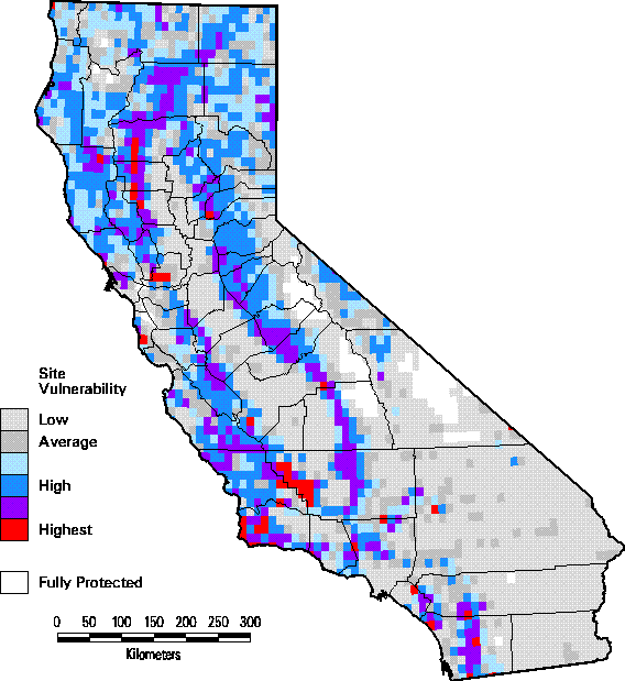
Figure 3. Site scoring by quadrangle for plant communities weighted by their priority category.
The map of site scores is shown in Figure 3. The highest scoring quadrangles tend to occur in a ring around the Great Central Valley, particularly in western Kern County, and in Glenn, Colusa, and Tehama counties. Western Santa Barbara County and Solano County contain other particularly high scoring clusters of quadrangles. Other relatively high scoring areas include the Sierra Nevada foothills, much of the Central Western region, parts of Shasta County, undeveloped areas throughout the Southwestern California region, and a small area along the border with Nevada in Lassen County. Low scoring sites occur throughout the Great Central Valley, Los Angeles Basin, and the Imperial Valley near the Mexican border where agriculture or urbanization have eliminated most of the native vegetation. Other low scoring areas occur in the higher elevations of the southern Sierra Nevada and the majority of the Mojave and Sonoran Desert regions where the plant communities are well-represented in managed areas and thus tend to have low priority. Readers should note that a quadrangle could have a low score and yet contain a rare community type that only occurs at that site.
CA-GAP Database Uses and Availability
The CA-GAP database provides researchers, resource managers, educators, and those interested in California's biodiversity with an unprecedented opportunity for study and conservation planning. Toward that end, the database and our final assessment are being published on compact disk in a user-friendly format with all software necessary to run it. The CD-ROM will be distributed through the California Department of Fish and Game, which is also assuming long-term responsibility for management and distribution of the data. The contents of the full report will also be available on the World Wide Web at http://www.biogeog.ucsb.edu/projects/gap/gap_home.html. Check this web site also for assistance with accessing to the database and ordering the CD-ROM.
The database will also be distributed on a CD-ROM. The CD-ROM disk will contain this report, GIS coverages (except see note below) and TM image mosaics, all metadata, an interactive atlas version with a customized graphical user interface to run ARCVIEW software to make routine queries of the database that are relevant to gap analysis.
Note: At the time of this report, access to the 1:100,000 scale land stewardship/management layer compiled for CA-GAP is restricted to subscribers of the state's Teale Data Center. Therefore it will not be distributed either through GAP or California Department of Fish and Game. Those interested in acquiring the coverage for a fee are directed to the Teale Data Center GIS Solutions Group, http://www.gislab.teale.ca.gov/ or (916) 263-1767, for details. Check the CA-GAP or the Fish and Game web sites, however, for the current status for this layer. As an alternative, CA-GAP has compiled a 1:2,000,000 scale version from unrestricted public-domain data. This lower resolution version is being distributed without restriction. Check the CA-GAP web site listed above for access.
Appropriate Uses: The following is a general list of applications:
- Statewide biodiversity planning
- Regional (Councils of Government) planning
- Regional habitat conservation planning
- County comprehensive planning
- Large area resource management planning
- Coarse-filter evaluation of potential impacts or benefits of major projects or plan initiatives on biodiversity, such as utility or transportation corridors, wilderness proposals, regional open space and recreation proposals, etc.
- Determining relative amounts of management responsibility for specific biological resources among land stewards to facilitate cooperative management and planning.
- Basic research on regional distributions of plants and animals and to help target both specific species and geographic areas for needed research.
- Environmental impact assessment for large projects or military activities.
- Estimation of potential economic impacts from loss of biological resource based activities.
- Education at all levels and for both students and citizens.
Inappropriate Uses: It is far easier to identify appropriate uses than inappropriate ones, however, there is a "fuzzy line" that is eventually crossed when the differences in resolution of the data, size of geographic area being analyzed, and precision of the answer required for the question are no longer compatible. Examples include:
- Use of the data to map small areas (less than thousands of hectares) typically requiring mapping resolution at 1:24,000 scale and using aerial photographs or ground surveys.
- Combining GAP data with other data finer than 1:100,000 scale to produce new hybrid maps or answer queries.
- Generating specific areal measurements from the data finer than the nearest thousand hectares (minimum mapping unit size and accuracy affect this precision).
- Establishing exact boundaries for regulation or acquisition.
- Establishing definite occurrence or non-occurrence of any feature for an exact geographic area (for land cover, the percent accuracy will provide a measure of probability).
- Determining abundance, health, or condition of any feature.
- Establishing a measure of accuracy of any other data by comparison with GAP data.
- Altering the data in any way and redistributing them as a GAP data product.
- Using the data without acquiring and reviewing the metadata and this report.
The California Department of Fish and Game will be the long-term custodian of the CA-GAP database, both for its distribution and its maintenance. Ultimately it is anticipated they will establish a web site for users to download the data. Check the CA-GAP web site at:
http://www.biogeog.ucsb.edu/projects/gap/gap_data.html
for information on how to contact the Department of Fish and Game.
CA-GAP Home | Overview | Report | Download GIS | CD-ROM | Site Index | National GAPTop of Page Send your comments to: stoms@geog.ucsb.edu
UCSB Biogeography Lab Home