Table of Contents
Identification Information
Data Quality Information
Spatial Data Organization Information
Spatial Reference Information
Entity and Attribute Information
Distribution Information
Metadata Reference Information
Contact Information
Data Set Identity: jepson
Description:
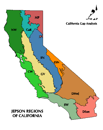
This layer delineates the geographic subdivisions of California defined for The Jepson Manual: Higher Plants of California (Hickman, 1993). These regions were developed for the Jepson flora to aid in describing where plant species were known to occur. The regions were defined by natural features, including broadly defined vegetation types, and geologic, topographic, and climatic variation. The Flora authors relied heavily on the Potential Natural Vegetation map of Küchler (1977) in delineating regions. The Flora included only a page-size representation of the map of three provinces, subdivided into ten regions, but also provided geographic descriptions of the boundaries between regions and subregions. Based on these descriptions, the Biogeography Lab digitized the boundaries of the ten regions using 1990 Landsat imagery and ancillary digital data at a 1:100,000 map scale. These regions were used for compiling and analyzing the California Gap Analysis database.
Supplemental Information: n/a
Data Set Status: in use
West Bounding Coordinate: -124.5048
East Bounding Coordinate: -114.2648
North Bounding Coordinate: 41.9886
South Bounding Coordinate: 32.4234
Theme Keyword: Ecoregions
Browse Graphic File Name: jepson.gif
Browse Graphic File Description: Graphic of the ten "Jepson"
regions of California.
Browse Graphic File Type: GIF
Use Restrictions: None
Access Limitations:
There are no restrictions of access to this dataset. However, the data are subject to revision. To ensure that the user has the latest version, copies should only be obtained from the UCSB ftp site or other authorized distributor.
Native Data Set Environment:
ARC/INFO software version 7.0.3 running on IBM RS6000 with AIX 3.2.5
Raster File Format: n/a
Raster File Sensor: n/a
Vector File Format: ARCE7 (ARC/INFO Export format, version 7)
Nonspatial File Format: n/a
Attribute Accuracy: 100%
Attribute Accuracy Explanation:
Proof-reading of data attributes against the map published in the Jepson Manual.
Logical Consistency Report:
Each attribute label was confirmed to be a member of the set of valid values, and each map unit has one and only one label.
Completeness Report:
The entire state (except for the offshore islands) is included in one of the ten regions.
Horizontal Positional Accuracy: unknown
Horizontal Positional Accuracy Explanation: n/a
Vertical Positional Accuracy: n/a
Vertical Positional Accuracy Explanation: n/a
Source Information:
1990 Landsat Thematic Mapper imagery was used to guide the delineation of boundaries when defined along features visible in the imagery such as rivers or the edge of distinctive vegetative types. The boundary of the Great Central Valley was delineated largely from the 1991 map of hardwoods (Pillsbury, 1991) which distinguishes the edge of the foothill woodlands from the valley grassland. The Jepson Manual (Hickman, 1993) contained descriptions of the region boundaries. These descriptions were followed with minor exceptions. The page-size map in the Manual was used as a general guide.
Source Date: 1990-1993
Source Distance Resolution: n/a
Process Description:
The boundary descriptions in the Jepson Manual were identified on 1990 Landsat TM images and digitized on-screen, based on changes in tone, color, or texture between vegetation types or along features such as rivers. In some cases, ancillary digital maps were used to guide the boundary location process where it was not distinct in the TM images. For instance, the boundary of the Great Central Valley was delineated largely from the 1991 map of hardwoods (Pillsbury, 1991) which distinguishes the edge of the foothill woodlands from the valley grassland. Label points were given the attributes for each region in the Jepson Manual.
Native Data Structure: spatial vector
Raster File Row (Line) Count: n/a
Raster File Column (Sample) Count: n/a
Raster File Vertical (Band) Count: n/a
Raster File Number of Bytes per Pixel: n/a
Geographic Coordinate Units: Degrees, minutes and decimal seconds
Map Projection Name: Albers Conical Equal Area
Map Projection Description:
Projection ALBERS
Units METERS
Spheroid CLARKE1866
Parameters:
Distance Resolution (meters): n/a
Altitude Resolution (meters): n/a
Attribute Labels:
ECOREGION Name of the region in the Jepson Manual
ABREV Abbreviated initials of the region name
Attribute Definition Source:
The Jepson Manual (Hickman, 1993)
Entity and Attribute Detail Citation:
Hickman, J. C. (ed.). 1993. The Jepson Manual of Higher Plants of California. University of California Press, Berkeley.
Distributor:
phone: 805-893-3438
fax: 805-893-3146
e-mail: fd@geog.ucsb.edu
ftp address:
ftp://ftp.biogeog.ucsb.edu/pub/org/biogeog/data/gap_analysis
URL:
http://www.biogeog.ucsb.edu/projects/gap/gap_data.html
Distribution Liability:
The University of California assumes no responsibility for application of the data beyond their original intent.
Standard Order Process:
Data are available through anonymous ftp and the World Wide Web at the ftp address and URL address listed under Distributor.
File Decompression Technique: None
Transfer Size: 1.0 Mb in gzip compressed format; 3.5 Mb uncompressed
Metadata Date: 07/15/98
Metadata Standard Name: Metadata Standards for Gap Analysis
Metadata Standard Version: 09/05/94
Metadata Review Date: n/a
Metadata Contact:
Contact Person Primary: Dr. David Stoms
Contact Mail Address:
Contact Voice Telephone: (805) 893-7655
Contact Facsimile Telephone: (805) 893-3146
Contact Electronic Mail Address:
stoms@geog.ucsb.edu