Table of Contents
Identification Information
Data Quality Information
Spatial Data Organization Information
Spatial Reference Information
Entity and Attribute Information
Distribution Information
Metadata Reference Information
Contact Information
Data Set Identity: ma2m
Description:
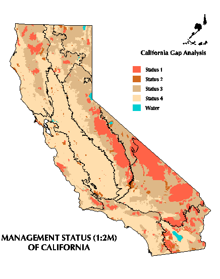
1:2 million scale land ownership and management of California, distinguishing local, state, and federal jurisdictions from private lands and delineating areas managed for the long-term maintenance of natural ecological processes and biodiversity. This layer therefore contains attributes both for ownership and for the level of biodiversity protection.
Supplemental Information: n/a
Data Set Status: in use
West Bounding Coordinate (degrees longitude): -124.5048
East Bounding Coordinate (degrees longitude): -114.2648
North Bounding Coordinate (degrees latitude): 41.9886
South Bounding Coordinate (degrees latitude): 32.4234
Theme Keyword: Ownership, Protected Areas
Browse Graphic File Name: ma2m.gif
Browse Graphic File Description: Four management status levels
in California.
Browse Graphic File Type: GIF
Use Restrictions:
THIS LAYER IS A 1:2 MILLION SCALE, GENERALIZED VERSION OF THE ORIGINAL 1:100,000 SCALE STEWARDSHIP MAP COMPILED FOR THE CALIFORNIA GAP ANALYSIS PROJECT. WHILE THIS GENERALIZED VERSION CAN BE DISTRIBUTED WITHOUT CHARGE OR RESTRICTION, USERS ARE CAUTIONED THAT IT IS NOT THE VERSION OF THE DATA USED FOR GAP ANALYSIS. IT IS ONLY BEING PROVIDED FOR GENERAL VISUALIZATION OF LAND OWNERSHIP AND MANAGEMENT AS A COURTESY TO USERS. THE 1:100,000 SCALE MAP COMPILED FOR GAP ANALYSIS IS RESTRICTED TO SUBSCRIBERS OF THE CALIFORNIA TEALE DATA CENTER. PLEASE CONTACT TEALE FOR CURRENT INFORMATION ABOUT FEES AND ACCESS.
Access Limitations:
This layer is entirely in the public domain and can be distributed freely. NOTE, HOWEVER, THE WARNING LISTED UNDER "USE RESTRICTIONS" ABOVE
Native Data Set Environment: ARC/INFO software version 7.0.3 running on IBM RS6000 with AIX 3.2.5
Raster File Format: n/a
Raster File Sensor: n/a
Vector File Format: ARCE7 (ARC/INFO Export format, version 7)
Nonspatial File Format: n/a
Attribute Accuracy: unknown
Attribute Accuracy Explanation: n/a
Logical Consistency Report:
Each attribute label was confirmed to be a member of the set of valid values, and each map unit has one and only one label.
Completeness Report:
Base land ownership derived from USGS 1:2,000,000 scale digital line graphs. Additional land ownership updated from various sources on published or agency maps, generally at 1:100,000 scale. Managed areas added from paper and digital sources from the responsible agency. Set of managed areas incorporated based on lists in Kreissman, B. 1991. California: An Environmental Atlas and Guide. Bear Klaw Press, Davis, CA. Additional managed areas identified from more recent legislation and agency contacts. Managed areas smaller than 200 hectares for upland sites and 80 hectares for wetland sites were not included on the assumption that they contribute little to regional biodiversity conservation. However, where digital map boundaries were readily available, these smaller sites were incorporated as well, but were labeled as a special management level.
NOTE THAT AT THE LOW RESOLUTION OF THE 1:2 MILLION SCALE BASE MAP, ONLY BOUNDARIES OF NATIONAL FORESTS AND OTHER LAND MANAGEMENT AGENCIES ARE SHOWN. PRIVATE INHOLDINGS IN GENERAL ARE NOT SHOWN. USERS ARE CAUTIONED THAT IN SOME INSTANCES, THIS MAP OVER-REPRESENTS THE EXTENT OF PUBLIC LANDS.
Some managed areas are nested within others. Because only one code is permitted per map unit, the one with the highest level of protection is encoded. This means that it may not be straightforward to extract or reselect all areas of a particular category. For instance, some Forest Service Research Natural Areas (RNA) are within Wilderness Areas. To extract all wilderness from the database, a user would have to know which specific RNA's, condor sanctuaries, etc. occur within wilderness.
Horizontal Positional Accuracy: unknown
Horizontal Positional Accuracy Explanation: n/a
Vertical Positional Accuracy: n/a
Vertical Positional Accuracy Explanation: n/a
Source Information:
The ownership data were based on the Managed Areas Database (MAD). MAD is a comprehensive GIS database for the conterminous United States which includes all types of managed areas. Examples include National and State Parks and Forests, Wilderness Areas, Indian and Military Reservations, and National Wildlife Refuges. Researchers at the Remote Sensing Research Unit at the University of California, Santa Barbara, compiled this database by integrating a number of data sources diverse in scale and map projection. The database has been compiled as a 1:2,000,000 scale product, and both the precision and accuracy of the database are in accord with that scale. MAD was based on the 1:2,000,000 scale Digital Line Graph files of boundaries produced by the U. S. Geological Survey.
Two major modifications were made to MAD data. The California Gap Analysis Project supplemented MAD with additional boundaries of managed areas not included in MAD (e.g., below MAD's 5000 ha minimum mapping unit) and replaced some boundaries with those digitized for GAP at 1:100,000 scale. Also, when MAD was begun, the USGS digital line graph boundary file die not include Bureau of Land Management lands. A more recent version has been distributed by the USGS. This newer version was used as a source of boundaries of larger tracts of BLM lands, although not every parcel was incorporated.
The managed area boundaries were compiled for GAP from many sources. Many larger areas could be found on the USGS 1:100,000 scale topographic maps revised in the 1980s. Fish and Game Ecological Reserves and Wildlife Areas and Nature Conservancy Preserves were provided as digital files from the California Department of Fish and Game's Heritage Program. ARC/INFO coverages of the Santa Monica Mountains National Recreation Area, BLM Areas of Critical Environmental Concern and some other managed areas were obtained from the responsible agency. USFS wilderness area boundaries were obtained from published and unpublished Forest Service maps. The wilderness areas and park designations in the California Desert Conservation Act of 1994 were obtained from the 1991 digital GIS coverage prepared by the BLM state office. Various paper maps were used to delineate state wildernesses and all other managed areas.
Source Date: 1975-1994
Source Distance Resolution (meters): 50
Process Description:
The original Managed Areas Database was projected to the standard map projection used for the California Gap Analysis Project and unioned with the state boundary to enclose lands that are not categorized as managed areas. The arcs were then moved into a new layer.
The California Gap Analysis Project had concurrently compiled a map of managed areas for the state at a 1:100,000 scale. Managed areas boundaries digitized or incorporated from other sources into the GAP 1:100,000 scale layer were extracted and moved into the 1:2,000,000 scale version. Managed areas were incorporated into this base coverage at UCSB. In addition, boundaries of BLM lands not already in the coverage were extracted from the newest USGS 1:2,000,000 scale digital line graph layer and added to the Land Ownership/Management layer.
Polygon labels were transferred from the GAP 1:100,000 scale layer into the corresponding polygons on the 1:2,000,000 scale layer. Attributes for the polygons include the owner or steward, management status, and a 10 character Heritage Program ID-code for managed areas. For further details on attributes, see:
Beardsley, K. and D. M. Stoms. 1993. Compiling a digital map of areas managed for biodiversity in California. Natural Areas Journal, 13: 177-190.
Native Data Structure: spatial vector
Raster File Row (Line) Count: n/a
Raster File Column (Sample) Count: n/a
Raster File Vertical (Band) Count: n/a
Raster File Number of Bytes per Pixel: n/a
Geographic Coordinate Units: Degrees, minutes and decimal seconds
Map Projection Name: Albers Conical Equal Area
Map Projection Description:
Projection ALBERS
Units METERS
Spheroid CLARKE1866
Parameters:
Distance Resolution (meters): 500
Altitude Resolution (meters): n/a
Attribute Label:
OWNER Code for responsible jurisdiction
MACODE Code for managed area
STATUS Code for management status level (4 classes)
MATYPE Prefix of MACODE (REDEFINEd item)
In related INFO tables:
OWNNAME Name of responsible jurisdiction
MANAME Name of managed area
EST_DATE Year of establishment
DESCRIPTION Comments about significant biodiversity elements in the area
Attribute Definition Source:
MACODE the Managed Area File of the California Natural Heritage Division
Entity and Attribute Detail Citation:
Beardsley, K. and D. M. Stoms. 1993. Compiling a digital map of areas managed for biodiversity in California. Natural Areas Journal, 13: 177-190.
Data dictionary with attribute codes (http://www.biogeog.ucsb.edu/projects/gap/meta/ma2mdd.html)
Distributor:
phone: 805-893-3438
fax: 805-893-3146
e-mail: fd@geog.ucsb.edu
ftp address:
ftp://ftp.biogeog.ucsb.edu/pub/org/biogeog/data/gap_analysis
URL:
http://www.biogeog.ucsb.edu/projects/gap/gap_data.html
Distribution Liability:
The University of California assumes no responsibility for application of the data beyond their original intent.
Standard Order Process:
Data are available through the World Wide Web at the URL address listed under Distributor.
File Decompression Technique:
ARC/INFO export file (ARCE7) with NONE compression option. Export file then compressed with gzip.
Transfer Size: 2.6 Mb in transfer (i.e., gzip) mode (expands to 9.4 Mb uncompressed .e00 file)
Metadata Date: 07/09/98
Metadata Standard Name: Metadata Standards for Gap Analysis
Metadata Standard Version: 09/05/94
Metadata Review Date: n/a
Metadata Contact:
Contact Person Primary: Dr. David Stoms
Contact Mail Address:
Contact Voice Telephone: (805) 893-7655
Contact Facsimile Telephone: (805) 893-3146
Contact Electronic Mail Address:
stoms@geog.ucsb.edu