Table of Contents
Identification Information
Data Quality Information
Spatial Data Organization Information
Spatial Reference Information
Entity and Attribute Information
Distribution Information
Metadata Reference Information
Contact Information
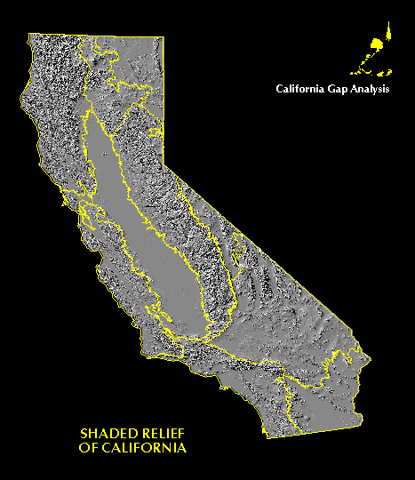
Data Set Identity: shade
Description:
Shaded relief image derived from mosaic of digital elevation model (DEM) grids covering the state of California, resampled to 100 m pixels. Data were derived from USGS 3 arc-second DEM files.
Supplemental Information: n/a
Data Set Status: in use
West Bounding Coordinate (degrees longitude): -124.5048
East Bounding Coordinate (degrees longitude): -114.2648
North Bounding Coordinate (degrees latitude): 41.9886
South Bounding Coordinate (degrees latitude): 32.4234
Theme Keyword: Topographic Data, shaded relief
Browse Graphic File Name:
shade.gif
Browse Graphic File Description:
Low resolution view of statewide shaded relief image.
Browse Graphic File Type: GIF
Use Restrictions:
This image is intended for cartographic reference purposes in the California Gap Analysis database and may not be suitable for some quantitative analyses.
Access Limitations:
None, the source data are in the public-domain so that this product can be freely distributed to others.
Native Data Set Environment:
Image Processing Workbench software running on IBM RS6000 with AIX 3.2.5
Raster File Format: IPW
Raster File Sensor: n/a
Vector File Format: n/a
Nonspatial File Format: n/a
Attribute Accuracy: n/a
Attribute Accuracy Explanation: n/a
Logical Consistency Report: n/a
Completeness Report:
Coverage provided for the entire state of California except for islands off the coast.
Horizontal Positional Accuracy: 130 m
Horizontal Positional Accuracy Explanation:
This is the objective for the DMA 1-degree DTED data, with a circular error at 90-percent probability. This positional accuracy may have been degraded slightly by additional GIS processing, such as changing map projections.
Vertical Positional Accuracy: +/- 30 m
Vertical Positional Accuracy Explanation:
This is the objective for the DMA 1-degree DTED data, with a linear error at 90-percent probability. This positional accuracy may have been degraded slightly by additional GIS processing, such as changing map projections.
Source Information:
USGS DEM files, from DMA DTED data which was developed from photographic and cartographic sources.
Source Date: n/a
Source Distance Resolution (meters): 3 arc seconds (approximately 75 x 90 m at the latitude of California)
Process Description:
A Digital Elevation Model consists of a sampled array of elevations for ground positions that are normally at regularly spaced intervals. The basic elevation model was produced by or for the Defense Mapping Agency, but is distributed by the EROS Data Center, in the DEM data record format. The majority of the 1-degree Digital Elevation Models are produced by DMA from cartographic and photographic sources. The digital elevation models distributed within the Department of Defense cover 1- x 1-degree blocks and are called Digital Terrain Elevation Data Level 1 (DTED-1). In reformatting the DMA product to create the DEM's, the USGS restructured the header records and data but did not change the basic elevation information. The 1- x 1- degree DEM files were converted to image format at UCSB, mosaicked together to form a single coverage of the entire state, and projected into the standard California Gap Analysis Albers projection, using a nearest neighbor sampling with a 100m pixel size. No attempt was made to fix seam problems between 1- x 1- degree blocks. The DEM was converted into a shaded relief image using the ARC/INFO HILLSHADE command with all default options. For further information about the source for this product, see:
U.S. Geological Survey, 1990. Digital Elevation Models, National Mapping Program Technical Instructions, Data Users Guide 5, Second Printing (Revised), Reston, Virginia.
Native Data Structure: spatial raster
Raster File Row (Line) Count: 10,546
Raster File Column (Sample) Count: 9,140
Raster File Vertical (Band) Count: 1
Raster File Number of Bytes per Pixel: 8
Geographic Coordinate Units: Degrees, minutes and decimal seconds
Map Projection Name: Albers Conical Equal Area
Map Projection Description:
Projection ALBERS
Units METERS
Spheroid CLARKE1866
Parameters:
Attribute Label: n/a
Attribute Definition Source: n/a
Entity and Attribute Detail Citation: n/a
Distributor:
phone: 805-893-3438
fax: 805-893-3146
e-mail: fd@geog.ucsb.edu
ftp address:
ftp://ftp.biogeog.ucsb.edu/pub/org/biogeog/data/gap_analysis
URL:
http://www.biogeog.ucsb.edu/projects/gap/gap_data.html
Distribution Liability:
The University of California assumes no responsibility for application of the data beyond their original intent.
Standard Order Process:
Data are available through anonymous ftp and the World Wide Web at the ftp address and URL address listed under Distributor.
File Decompression Technique:
Image file was compressed with tar, then compressed with gzip.
Transfer Size: 27.0 Mb in gzip format; 96 Mb in uncompressed tar format
Metadata Date: 07/15/98
Metadata Standard Name: Metadata Standards for Gap Analysis
Metadata Standard Version: 09/05/94
Metadata Review Date: n/a
Metadata Contact:
Contact Person Primary: Michael Bueno
Contact Mail Address:
Contact Voice Telephone: (805) 893-7044
Contact Facsimile Telephone: (805) 893-3146
Contact Electronic Mail Address:
bueno@geog.ucsb.edu