Table of Contents
Identification Information
Data Quality Information
Spatial Data Organization Information
Spatial Reference Information
Entity and Attribute Information
Distribution Information
Metadata Reference Information
Contact Information
Data Set Identity: tm_image
Description:
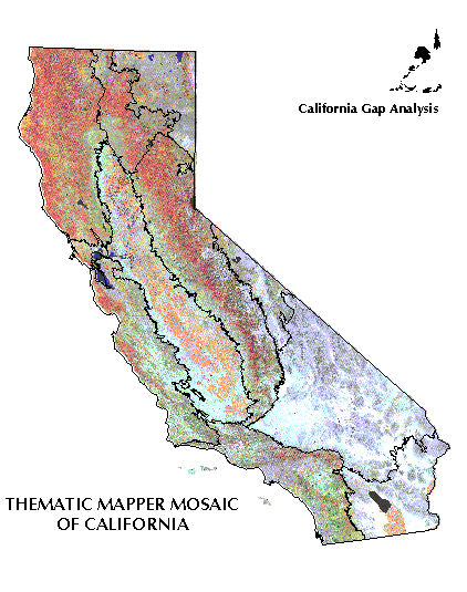
Mosaic of Landsat Thematic Mapper (TM) images covering the state of California, resampled to 100 m pixels. A composite of bands 3 (red), 4, near-infrared, and 5 (mid-infrared).
Supplemental Information: n/a
Data Set Status: in use
West Bounding Coordinate (degrees longitude): -124.5048
East Bounding Coordinate (degrees longitude): -114.2648
North Bounding Coordinate (degrees latitude): 41.9886
South Bounding Coordinate (degrees latitude): 32.4234
Theme Keyword: n/a
Browse Graphic File Name: : calif_tm.gif
Browse Graphic File Description: Low resolution view of statewide mosaic image shown with band 4 in red, band 5 in green, and band 3 in blue.
Browse Graphic File Type: GIF
Use Restrictions:
Because this image has been degraded by resampling from the original 30 m imagery, it is not suitable for quantitative image analysis or classification.
Access Limitations:
The processing (projection, resampling) has modified the copyrighted image data such that this product can be freely distributed to others.
Native Data Set Environment:
Image Processing Workbench software running on IBM RS6000 with AIX 3.2.5
Raster File Format: IPW
Raster File Sensor: Landsat TM
Vector File Format: n/a
Nonspatial File Format: n/a
Attribute Accuracy: n/a
Attribute Accuracy Explanation: n/a
Logical Consistency Report: n/a
Completeness Report:
Coverage provided for the entire state of California except for the tip of the Palos Verdes peninsula in Los Angeles County and islands off the coast.
Horizontal Positional Accuracy: unknown
Horizontal Positional Accuracy Explanation: n/a
Vertical Positional Accuracy: n/a
Vertical Positional Accuracy Explanation: n/a
Source Information: Landsat TM
Source Date:
| Path & Row | Scene Date | Scene Location |
| 38/36 | xx/xx/89 | Lake Havasu |
| 38/37 | 05/25/1990 | Yuma |
| 39/35 | 06/30/1989 | Las Vegas |
| 39/36 | 06/xx/91 | Needles |
| 39/37 | 05/19/1991 | Salton Sea |
| 40/35 | 05/26/1991 | Death Valley |
| 40/36 | 08/27/1990 | San Bernardino |
| 40/37 | 08/27/1990 | Santa Ana |
| 41/34 | 07/30/1989 | Goldfield |
| 41/35 | 09/03/1990 | Fresno |
| 41/36 | 09/03/1990 | Los Angeles |
| 42/33 | 07/05/1989 | Virginia City |
| 42/34 | 08/25/1990 | Yosemite |
| 42/35 | 08/25/1990 | Corcoran |
| 42/36 | 09/16/1986 | Santa Barbara |
| 43/32 | 07/28/1989 | Susanville |
| 43/33 | 08/16/1990 | Tahoe |
| 43/34 | 08/16/1990 | San Jose |
| 43/35 | 08/16/1990 | Monterey |
| 44/31 | 06/20/1990 | Modoc |
| 44/32 | 06/20/1990 | Lassen |
| 44/33 | 06/20/1990 | Sacramento |
| 44/34 | 06/20/1990 | Oakland |
| 45/31 | 06/27/1990 | Yreka |
| 45/32 | 06/27/1990 | Trinity |
| 45/33 | 06/27/1990 | Ukiah |
| 46/31 | 05/01/1990 | Crescent City |
| 46/32 | 05/01/1990 | Eureka |
Source Distance Resolution (meters): 25 or 30 (depending upon scene)
Process Description:
Most images were terrain corrected by EROS Data Center and obtained in UTM projection. All images were projected at UCSB into Albers Equal Area using a nearest neighbor sampling with a 100m pixel size. Images were mosaicked together by using what was subjectively determined to be the "best" image for areas of overlap between scenes. This was accomplished by the precedence order of the images in the ARC GRID MERGE command.
Native Data Structure: spatial raster
Raster File Row (Line) Count: 14,438
Raster File Column (Sample) Count: 18,002
Raster File Vertical (Band) Count: 3
Raster File Number of Bytes per Pixel: 8
Geographic Coordinate Units: Degrees, minutes and decimal seconds
Map Projection Name: Albers Conical Equal Area
Map Projection Description:
Projection ALBERS
Units METERS
Spheroid CLARKE1866
Parameters:
Altitude Resolution (meters): n/a
Attribute Label: n/a
Attribute Definition Source: n/a
Entity and Attribute Detail Citation: n/a
Distributor:
Dr. Frank Davis
Department of Geography
University of California
Santa Barbara, CA 93106-4060
phone: 805-893-3438
fax: 805-893-3146
e-mail: fd@geog.ucsb.edu
ftp address:
ftp://ftp.biogeog.ucsb.edu/pub/org/biogeog/data/gap_analysis
URL:
http://www.biogeog.ucsb.edu/projects/gap/gap_data.html
Distribution Liability:
The University of California assumes no responsibility for application of the data beyond their original intent.
Standard Order Process:
Data are available through anonymous ftp and the World Wide Web at the ftp address and URL address listed under Distributor.
File Decompression Technique:
Image file was compressed with tar, then compressed with gzip.
Transfer Size: stored by region or 100k quadrangle, file size varies
The statewide mosaic is stored in six files:
| calif.tar.gz.0 | 20.0 Mb |
| calif.tar.gz.1 | 20.0 Mb |
| calif.tar.gz.2 | 20.0 Mb |
| calif.tar.gz.3 | 20.0 Mb |
| calif.tar.gz.4 | 20.0 Mb |
| calif.tar.gz.5 | 20.0 Mb |
| calif.tar.gz.6 | 10.0 Mb |
The regional mosaics are:
| Cascades Ranges | caseco.tar.gz | 7.8 Mb |
| Central Western | cweco.tar.gz | 14.6 Mb |
| East of the Sierra Nevada | esneco.tar.gz | 6.5 Mb |
| Great Central Valley | gveco.tar.gz | 22.1 Mb |
| Modoc Plateau | modeco.tar.gz | 8.7 Mb |
| Mojave Desert | mojeco.tar.gz | 24.8 Mb |
| Northwestern | nweco.tar.gz | 16.4 Mb |
| Sierra Nevada | sneco.tar.gz | 43.6 Mb |
| Sonorna Desert | soneco.tar.gz | 10.8 Mb |
| Southwestern | sweco.tar.gz | 12.3 Mb |
Metadata Date: 07/09/98
Metadata Standard Name: Metadata Standards for Gap Analysis
Metadata Standard Name: 09/05/94
Metadata Review Date: 12/09/96
Metadata Contact:
Dr. David Stoms
Department of Geography
University of California
Santa Barbara, CA 93106-4060
phone: 805-893-7655
fax: 805-893-3146
e-mail: stoms@geog.ucsb.edu
Contact Person Primary: Michael Bueno
Contact Mail Address:
Department of Geography
University of California
Santa Barbara, CA 93106-4060
Contact Voice Telephone: (805) 893-7044
Contact Facsimile Telephone: (805) 893-3146
Contact Electronic Mail Address:
bueno@geog.ucsb.edu