Table of Contents
Identification Information
Data Quality Information
Spatial Data Organization Information
Spatial Reference Information
Entity and Attribute Information
Distribution Information
Metadata Reference Information
Contact Information
I. IDENTIFICATION INFORMATION
Data Set Identity: usgs100k
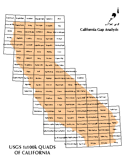
Description: Boundaries of the 100k quadrangles of California to
be used for geographic reference.
Supplemental Information: n/a
Data Set Status: in use
West Bounding Coordinate: -124.5048
Theme Keyword: Geographic grid
Browse Graphic File Name: usgs100k.gif
Use Restrictions: none
ARC/INFO software version 7.0.3 running on IBM RS6000 with AIX 3.2.5
Raster File Format: n/a
Attribute Accuracy:
Quad names were assigned from the Index to topographic and other Map Coverage:
California, published by USGS and therefore should contain the correct
official names. However, since these names were entered by hand,
it is possible that typographic or logical errors could have been made.
Attribute Accuracy Explanation: n/a
Logical Consistency Report: n/a
Completeness Report:
Quadrangles cover the entire state of California and all polygons have a name
corresponding to the USGS quadrangle map series name.
Horizontal Positional Accuracy: n/a
This coverage was created from a grid in latitude and longitude coordinates.
At that stage it was perfectly accurate. Positional errors would only arise
in the projection from geographic coordinates into Albers equal area. The
DENSIFY 0.03125 option was given in the PROJECT file to provide reasonable
curvature of grid lines with spacing of vertices at 0.03125 degrees.
Vertical Positional Accuracy: n/a
Source Information: n/a
Process Description:
A grid of 30 minutes of latitude and and 60 minutes of longitude was
created with the GENERATE command that included all of California.
The index of topographic maps was consulted for assigning the official
USGS 100k map series quadrangle name.
The coverage was then projected into the standard Albers
projection with the DENSIFY 0.03125 option in the PROJECT file to provide
reasonable curvature of grid lines with spacing of vertices at 0.03125
degrees.
Native Data Structure: spatial vector
Geographic Coordinate Units: Degrees, minutes and decimal seconds
Projection ALBERS
Units METERS
Spheroid CLARKE1866
Parameters:
Distance Resolution (meters): 50
Attribute Label:
QUADNAME USGS 100k quad name
Attribute Definition Source:
USGS, National Mapping Program. Index to topographic and other map coverage:
California. 38121-MI-99X.
Entity and Attribute Detail Citation: n/a
Distributor:
phone: 805-893-3438
Distribution Liability:
The University of California assumes no responsibility for application of the
data beyond their original intent.
Standard Order Process:
Data are available through anonymous ftp and the World Wide Web at the ftp
address and URL address listed under Distributor.
File Decompression Technique:
ARC/INFO export file (ARCE7) with NONE compression option.
Transfer Size: 0.35 megabytes (uncompressed)
Metadata Date: 07/09/98
Contact Person Primary: Dr. David Stoms
Contact Voice Telephone: (805) 893-7655
East Bounding Coordinate: -114.2648
North Bounding Coordinate: 41.9886
South Bounding Coordinate: 32.4234
Browse Graphic File Description: 100k quadrangle boundaries of California.
Browse Graphic File Type: GIF
Access Limitations: none
Native Data Set Environment:
Raster File Sensor: n/a
Vector File Format: ARCE7 (ARC/INFO Export format, version 7)
Nonspatial File Format: n/a
II. DATA QUALITY INFORMATION
Horizontal Positional Accuracy Explanation:
Vertical Positional Accuracy Explanation: n/a
Source Date: n/a
Source Distance Resolution: 50 meters
III. SPATIAL DATA ORGANIZATION INFORMATION
Raster File Row (Line) Count: n/a
Raster File Column (Sample) Count: n/a
Raster File Vertical (Band) Count: n/a
Raster File Number of Bytes per Pixel: n/a
IV. SPATIAL REFERENCE INFORMATION
Map Projection Name: Albers Conical Equal Area
Map Projection Description:
1st standard parallel 34 0 0.000
2nd standard parallel 40 30 0.000
central meridian -120 0 0.00
latitude of projection's origin 0 0 0.000
false easting (meters) 0.00000
false northing (meters) -4000000.0000
Altitude Resolution (meters): n/a
V. ENTITY/ATTRIBUTE INFORMATION
VI. DISTRIBUTION INFORMATION
Dr. Frank Davis
Department of Geography
University of California
Santa Barbara, CA 93106-4060
fax: 805-893-3146
e-mail: fd@geog.ucsb.edu
ftp address:
ftp://ftp.biogeog.ucsb.edu/pub/org/biogeog/data/gap_analysis
URL:
http://www.biogeog.ucsb.edu/projects/gap/gap_data.html
VII. METADATA REFERENCE INFORMATION
Metadata Standard Name: Metadata Standards for Gap Analysis
Metadata Standard Version: 09/05/94
Metadata Review Date: n/a
Metadata Contact:
Dr. David Stoms
phone: 805-893-7655
fax: 805-893-3146
e-mail: stoms@geog.ucsb.edu
VIII. CONTACT INFORMATION
Contact Mail Address:
Department of Geography
University of California
Santa Barbara, CA 93106-4060
Contact Facsimile Telephone: (805) 893-3146
Contact Electronic Mail Address:
stoms@geog.ucsb.edu