

What's New
Research & Projects Publications
People
Data
Links
Gap Analysis of the Intermountain Semi-Desert Ecoregion
Problem Statement
Vegetation Mapping Approach
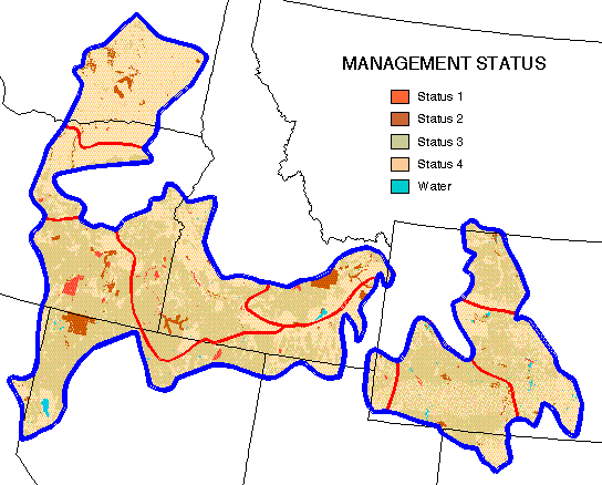
Management Status Mapping
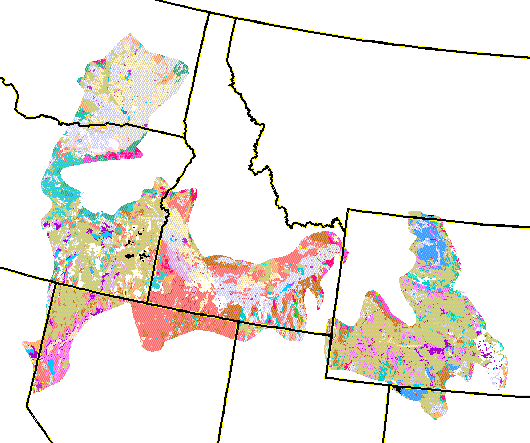
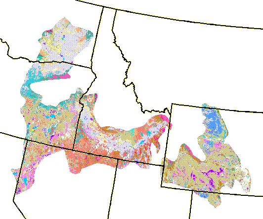
ResultsLand-Cover Map On-Line
- Metadata
August 7, 1998
- Download map as ARC/INFO export file
Problem Statement
The Biological Resources Division of USGS coordinates the Gap Analysis Program (GAP), a proactive conservation assessment to identify "gaps" in the protection of native biodiversity (Scott et al. 1993). Maps of plant cover types are compiled over political units (i.e., individual states), but analysis must also be conducted over ecologically meaningful regions. Although GAP has standards for mapping land cover, the individual states often generate products with different levels of spatial and taxonomic detail, due in part to the evolution of the standards over the duration of the program. The objective of a regional gap analysis is to evaluate the conservation status of cover types (following the Driscoll classification schema derived from that of UNESCO and now proposed as the federal National Vegetation Classification System standards). Initial examination suggested that simply mosaicking the state maps together would not provide the consistent product needed. Remapping the region from scratch was unacceptable given the investment in producing the state maps. The task then was to compile a regional map from the existing GAP state maps, while improving the spatial and taxonomic consistency.
This project was funded by the IBM Environmental Research Program and the national Gap Analysis Program (GAP).
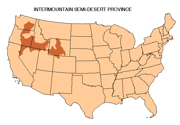
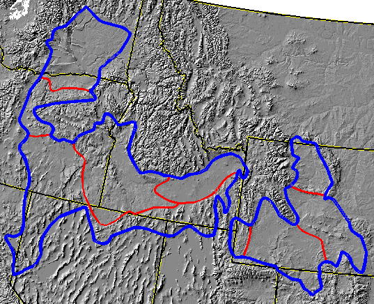
The land cover maps for Bailey et al.'s (1994) Intermountain Semi-Desert Province (ISD) (see map or shaded relief) (Washington, Oregon, Idaho, Nevada, California, Utah, Colorado, and Wyoming) were cross-walked into consistent cover types according to the GAP/UNESCO system at their finest level of the hierarchy (see the state maps at the alliance level-revised September 26, 1996). Four main obstacles were apparent:
1) not all states distinguished forest from woodland which is at the highest division of the UNESCO classification.
2) Some cover classes were labeled as mosaics of more than one type, often from two different UNESCO classes or subclasses. Furthermore, four states (CA, WA, WY, and CO) labeled map units as landscape mosaics comprised of two or three cover types.
3) Taxonomic (floristic) detail varied between states and between classes.
4) The spatial grain tended to be much finer in states which used supervised classification of digital imagery from those that used a photointerpretation approach.The potential consequences of using the map data as given was that the areal extent and locations of cover types could be inaccurate which could affect their apparent management status. Even the esthetic appearance of this intial regional map could create scepticism among policy makers and the public.
Vegetation Mapping Approach
A workshop was held at UCSB in June, 1996, to plan the mapping strategy for the ecoregion. The workshop (members listed below) reviewed the cross-walk to alliance types, the map-guided classification approach, and the potential publication alternatives. The following persons attended the workshop:
Frank W. Davis, California GAP
David M. Stoms, California GAP
Michael J. Bueno, California GAP
Ken Driese, Wyoming GAP
Blair Csuti, Oregon GAP
Jimmy Kagan, Oregon GAP
Michael Murray, Idaho GAP
Chris Grue, Washington GAP
Kelly Cassidy, Washington GAPThe first phase of the regional mapping process was to cross-walk the state GAP land cover types into a consistent set of alliances. This has been done (see cross-walk table) iteratively, with review by the project collaborators from the state GAP projects.
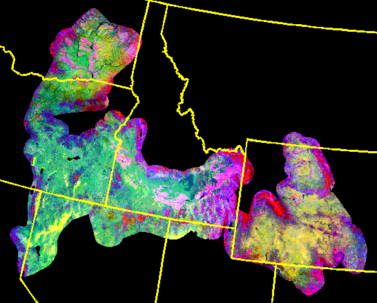
A map-guided classification technique was developed to classify multi-temporal AVHRR data so that plant phenology and surface temperature variation can be incorporated in the classification. This utilizes an independent image dataset while making maximum use of the existing GAP land cover map information. First, daily AVHRR images for the 1990 growing season were processed into ten-day images to remove cloud cover (Stoms et al, in review). AVHRR datasets were generated for four periods throughout the 1990 growing season (April, June, July, and September) to capture the main intra-annual variation of the phenology of the semiarid vegetation of this region. For each of the four periods, the derived datasets included Normalized Difference Vegetation Index (NDVI), brightness temperature of band 4, and near infra-red reflectance of band 2. Principal components were then derived from the four sets of AVHRR composites to further reduce noise. Image classification is being done using the state GAP land cover maps, cross-walked to alliances, as training data. The process is iterative, in that strong associations between spectral classes and cover types are assigned first, and further iterations only work on the remaining unclassified pixels. Some polygons and classes such as water bodies and riparian forests that were better mapped from TM data by the state GAP projects will be retained in the new map. The map was then reviewed by the project collaborators and modified as suggested.
Management Status Mapping
The state land stewardship/management maps were obtained and assigned to the four GAP management status classes according to the program standards. Many of the states already had made these assignments (Washington, California, and Wyoming), while others had ownership but not specific status assignments (Montana, Colorado, Utah and Nevada). Idaho had a coverage for status 1 and 2 but not for 3 and 4. Oregon had a 1-10 rating and rules for cross-walking to the 4 class GAP system. UCSB reviewed the state maps, made a comparative table of assignments, and compiled a regional map for the ISD Ecoregion (revised September 12, 1996). Some state assignments were modified to increase regional consistency, such as all water bodies being assigned to status 0. A few questions remain to be resolved such as Department of Energy sites. The Idaho National Engineering Lab was assigned to status 2, while the Hanford Lab in Washington was assigned partly to 2 but mostly to 4.
Results
An iterative, "map-guided" classification approach was developed to compile a spatially and thematically consistent, seamless land-cover map of the entire Intermountain Semi-Desert ecoregion from a set of semi-independent subregional maps derived by various methods. A multi-temporal dataset derived from AVHRR data was classified using the subregional maps as training data. The resulting regional map attempted to meet the guidelines of the proposed National Vegetation Classification Standards for classification at the alliance level. The approach generally improved the spatial properties of the regional mapping, while maintaining the thematic detail of the source maps. The methods described may be useful in many situations where mapped information exists but is incomplete, compiled by different methods, or is based on inconsistent classification systems.A conservation gap analysis was conducted for the Intermountain Semi-Desert ecoregion to assess the representation of land-cover types within areas managed primarily for biodiversity objectives. Mapped distributions of plant communities were summarized by land management status categories. The total amount of land permanently protected in the ecoregion is less than 4% and most types that are characteristic of the region have less than 10%. Of 48 land-cover types, twenty were found to be particularly vulnerable to potential loss or degradation, because of low level of representation in biodiversity management areas and the impact of expected land use activities. The gap analysis data and findings will be useful in providing a regional perspective in project impact assessment and future conservation planning within this ecoregion.
Two manuscripts have been recently published in scientific journals, one on the gap analysis of the ecoregion, the other on the mapping technique. The manuscript citations are:
Stoms, D. M., F. W. Davis, K. L. Driese, K. M. Cassidy, and M. P. Murray. 1998. Gap analysis of the vegetation of the Intermountain Semi-Desert Ecoregion. Great Basin Naturalist. 58: 199-216.
Stoms, D. M., M. B. Bueno, F. W. Davis, K. M. Cassidy, K. L. Driese, and J. S. Kagan. 1998. Map-guided classification of regional land-cover with multi-temporal AVHRR data. Photogrammetric Engineering and Remote Sensing 64: 831-838.
The Nature Conservany is using these GAP data from the Columbia Plateau portion of this ecoregion as the coarse-filter component in developing a regional portfolio of conservation sites.
Please send comments to David Stoms: stoms@geog.ucsb.edu
Go to UCSB IBM ERP home page
