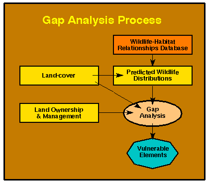
Figure 1. Summary of steps in the gap analysis process.
Conservation assessment and reserve siting and design (Figure 2) are now supported by advanced mapping technologies such as satellite remote sensing and machine-assisted image analysis, and by geographic information systems (GIS) for spatial data analysis and display (Davis et al. 1990, Davis and Simonett 1991). However, a number of scientific and technical obstacles currently impede large scale conservation analyses. We are severely limited by the lack of biological inventories, inadequate knowledge of species' habitat requirements, and by immature algorithms for modeling species spatial and temporal dynamics. Progress in conservation assessment and planning is severely and unnecessarily limited by hardware and software for such mapping and spatial analysis. Specifically:
- biogeographers and conservation biologists do not have adequate computing resources to analyze the large volumes of data involved in conservation assessments;
- data management systems in general use are poorly designed for manipulation of heterogeneous biogeographic data;
- there is practically no coupling among database management systems and analytical software used in biodiversity analyses;
- it is difficult to visualize biogeographical data sets and model outputs with existing display tools; and
- spatial modeling and decision support are constrained by inadequate hardware and cumbersome protocols for conducting sensitivity and error propagation analyses.
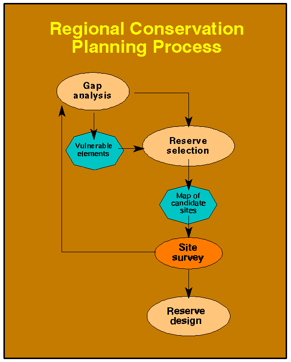
Figure 2. Flowchart of regional conservation planning process.
B. Goals and Objectives
The goal of this project was to design and test a prototype Spatial Modeling and Decision Support System for Conservation of Biological Diversity. We are not computer scientists, and it was not our intent to build new spatial database or visualization packages. Nor did we intend to program generic scientific applications for existing software. Instead, our research program was specifically aimed at exploiting IBM hardware and, to the extent possible, existing software, to develop application-specific computational tools for maintenance and analysis of biodiversity databases. Our programming effort focused on building interfaces between existing packages and on developing database functions tailored to the needs of gap analysis and reserve siting. These tools were applied to two specific research problems: a gap analysis of the Intermountain Semi-Desert Ecoregion in nine western states and design of reserve systems for the Southwestern California and the Sierra Nevada regions. The project was closely tied to the USGS-Biological Resources Division's Gap Analysis Program. During the research study, a new opportunity to work within the US Forest Service's Sierra Nevada Ecosystem Project allowed us to expand our research on the reserve siting problem into an additional region and planning activity.
Our project objectives were to:
![]() Design and
enable a prototype "regional" computing facility for storage,
analysis and visualization of biodiversity data.
Design and
enable a prototype "regional" computing facility for storage,
analysis and visualization of biodiversity data.
![]() Program
a set of specific software applications to support national (and potentially
international) gap analysis.
Program
a set of specific software applications to support national (and potentially
international) gap analysis.
![]() Conduct
a conservation gap analysis of the Intermountain Semi-Desert Ecoregion
over nine western states.
Conduct
a conservation gap analysis of the Intermountain Semi-Desert Ecoregion
over nine western states.
![]() Develop
applications for monitoring wildlife habitats using multi-temporal satellite
imagery.
Develop
applications for monitoring wildlife habitats using multi-temporal satellite
imagery.
![]() Develop
software to support reserve siting and reserve design and apply it to reserve
design in southern California and the Sierra Nevada.
Develop
software to support reserve siting and reserve design and apply it to reserve
design in southern California and the Sierra Nevada.
To meet these objectives, the UCSB project embarked on research into several, interrelated components of regional conservation assessment and planning, as illustrated in Figure 3.
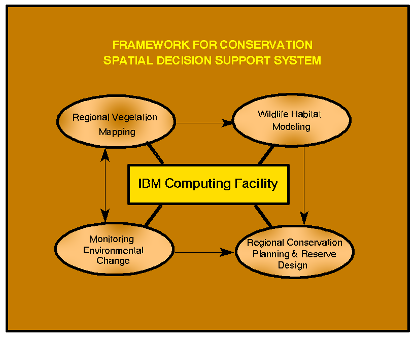
Figure 3. Framework for a Conservation Spatial Decision Support System.
The research was expected to have direct and immediate impact on the design of information systems for regional conservation assessment. The Gap Analysis Program has very high visibility both nationally and internationally. The research tools developed in this project as well as findings from application of those tools were intended to be of interest to conservation biologists, biogeographers, resource planners and managers, as well as to computer scientists designing next generation DBMS and spatial decision support systems. Many of the application programs were to be made available to other gap analysis projects and related research efforts. Publication of a number of peer-reviewed journal articles and book chapters was anticipated from the project. The upgrade in the computing facilities of the Biogeography Lab and creation of a state-of-the-art prototype regional biodiversity center was anticipated to lead to additional opportunities for leveraging the accomplishments from the IBM-ERP gift. Finally, this project was designed to contribute to training and education of a number of graduate and undergraduate students in geography, computer science, and biology at UCSB.
Next Section