

What's New
Research & Projects Publications
People
Data
Links
7. MANAGEMENT PRIORITIES FOR PLANT COMMUNITIES
The purpose of gap analysis is to identify land-cover types and vertebrate species in need of additional protection before they become critically threatened. The gap analysis approach uses management intent expressed in legislation, designation, or plans as indicators of the kinds of activities that may be permitted and hence of the potential impact on biodiversity. The previous two chapters summarized the management status of California's land-cover types, wildlife habitats, and vertebrate species. Here we identify the highest p riority elements based in part on management status and partly on other factors such as their rarity and endemism, their condition, the historical loss estimated to have occurred, and additional information about the kinds of activities that are likely to occur in each type. Table 7-1 lists the highest priority plant communities, organized into seven categories, from the statewide assessment and the vulnerable communities in the ten Jepson regions of California (Hickman 1993; see Appendix for details on regional assessments).
Within the set of plant communities, we distinguish seven categories. The first two categories include all those rated as rare by the NHD (S1 or S2 in Table 5-2). Of these, the highest priority (Group A in Table 7-1) is for rare communities with less than 20% level of status 1 and 2 management, while the second priority types have more than 20% (Group B).
For widespread community types, priorities were set based on a combination of two factors: percentage of status 1 and 2 lands and an index of threat. The threat index was calculated as a sum of roadedness (Chapter 4) and projected population growth (Chapter 5), normalized by their mean values, and rescaled so that absence of threat is equal to zero as shown in Figure 7-1. The first group (Group C) of common communities was characterized by a threat index > 3.75, indicating a relatively high degree of either past disturbance or future loss. Note that this threshold level was selected as a natural break in the set of plant communities, not on any a priori or theoretical basis. It had the further advantage of allowing us to divide communities into approximately equal-sized groups. Virtually all Group C community types were also relatively under-represented (< 20% status 1 and 2). The remaining four groups all appear relatively less threatened by roads or future development (threat index < 3.75) and were categorized based on their level of protection into roughly equal numbers of types in each group. We used the same break points as shown in Table 5-2, i.e., 10%, 20%, and 50%, in decreasing order of priority. Five exceptions were made to these general rules. Four types that were rated as rare by NHD were mapped over extensive areas by CA-GAP, perhaps due to differences in interpretation. We therefore chose to assign Mojave Mixed Steppe, Upland Redwood Forest, Westside Ponderosa Pine Forest, and Eastside Ponderosa Pine Forest to groups G, E, E, and D respectively, as if they were not rare types. Also, we assigned Tamarisk Scrub to group G because it is not a native community type and in fact is generally considered a pest species. The remaining urban, agricultural, and non-vegetated land cover types were assigned to group H that has no conservation priority for its vegetation values. There may still be important habitats and other ecosystem values, however, in the non-vegetated types (e.g., water bodies, sand dunes, rock outcrops, etc.).
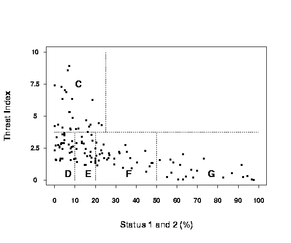
Figure 7-1. Vulnerability groups of widespread plant communities from the statewide gap analysis based on a combination of current protection and threat.
Table 7-1. Statewide and regional conservation priorities of plant community types based on gap analysis. Bullets indicate occurrence of the type in the region >25 km², a plus sign '+' indicates <25 km². Shading in the cell indicates the type is considered vulnerable within that region (see regional gap analysis summaries in the appendix for details). An asterisk after the community name indicates a type described for CA-GAP. Priorities decrease alphabetically; that is, "A" is highest priority and "G" is lowest.
Priority Level
CNDDB Code
CNDDB Community Name (Holland 1986)
SW
CW
NW
GV
CAS
MOD
ESN
SN
MOJ
SON
A
21210
Northern Foredunes
+
+
A
21310
Northern Dune Scrub
·
B
21320
Central Dune Scrub
+
F
22000
Desert Dunes
·
·
B
23300
Monvero Residual Dunes
+
B
31100
Northern Coastal Bluff Scrub
·
A
31200
Southern Coastal Bluff Scrub
+
C
32100
Northern (Franciscan) Coastal Scrub
·
·
C
32200
Central (Lucian) Coastal Scrub
·
C
32300
Venturan Coastal Sage Scrub
·
·
C
32500
Diegan Coastal Sage Scrub
·
D
32600
Diablan Sage Scrub
·
·
C
32700
Riversidian Sage Scrub
·
F
33100
Sonoran Creosote Bush Scrub
·
·
F
33200
Sonoran Desert Mixed Scrub
·
F
34100
Mojave Creosote Bush Scrub
·
·
+
·
west only·
G
34210
Mojave Mixed Woody Scrub
·
·
·
·
G
34220
Mojave Mixed Steppe
·
G
34240
Mojave Mixed Woody and Succulent Scrub
·
·
G
34300
Blackbush Scrub
·
·
·
D
35100
Great Basin Mixed Scrub
·
·
·
·
·
G
35110
Salvia dorri/ Chamaebatiaria scrub *
·
F
35210
Big Sagebrush Scrub
·
+
+
·
·
·
·
·
D
35211
Low Sagebrush Scrub *
+
·
·
·
D
35212
Silver Sagebrush Scrub *
·
·
G
35213
Black Sagebrush Scrub *
+
E
35220
Subalpine Sagebrush Scrub
·
·
D
35400
Rabbitbrush Scrub
+
+
·
+
·
·
E
35500
Cercocarpus ledifolius Woodland *
+
·
·
·
·
C
36110
Desert Saltbush Scrub
·
·
·
west only·
F
36120
Desert Sink Scrub
·
·
west only+
D
36130
Desert Greasewood Scrub
·
·
+
G
36140
Shadscale Scrub
·
·
G
36150
Desert Holly Scrub *
·
A
36210
Valley Sink Scrub
·
A
36220
Valley Saltbush Scrub
+
·
A
36320
Interior Coast Range Saltbush Scrub
·
C
37110
Northern Mixed Chaparral
·
+
·
·
·
C
37120
Southern Mixed Chaparral
·
E
37200
Chamise Chaparral
·
·
·
+
·
·
C
37300
Red Shank Chaparral
·
+
E
37400
Semi-Desert Chaparral
·
·
·
·
·
·
F
37510
Mixed Montane Chaparral
·
+
·
·
·
E
37520
Montane Manzanita Chaparral
+
+
·
·
·
·
E
37530
Montane Ceanothus Chaparral
·
+
·
·
·
·
E
37541
Shin Oak Brush
·
·
·
F
37542
Huckleberry Oak Chaparral
·
·
E
37550
Bush Chinquapin Chaparral
+
·
·
A
37610
Mixed Serpentine Chaparral
·
·
E
37620
Leather Oak Chaparral
·
+
E
37810
Buck Brush Chaparral
·
·
·
·
·
·
E
37820
Blue Brush Chaparral
·
+
C
37830
Ceanothus crassifolius Chaparral
·
+
C
37840
Ceanothus megacarpus Chaparral
·
+
F
37900
Scrub Oak Chaparral
·
·
+
+
·
F
37A00
Interior Live Oak Chaparral
·
·
·
·
·
·
F
37B00
Upper Sonoran Manzanita Chaparral
·
·
·
A
37C10
Northern Maritime Chaparral
+
A
37C20
Central Maritime Chaparral
·
A
37D00
Ione Chaparral
+
F
37E00
Mesic North Slope Chaparral
+
·
·
+
·
C
37G00
Coastal Sage-Chaparral Scrub
·
·
F
39000
Upper Sonoran Subshrub Scrub
·
·
+
A
41000
Coastal Prairie
·
·
C
42110
Valley Needlegrass Grassland
+
+
B
42120
Valley Sacaton Grassland
+
D
42160
Desert Native Grassland *
·
D
42200
Non-Native Grassland
·
·
·
·
·
·
+
·
·
·
A
42300
Wildflower Field
+
A
43000
Great Basin Grassland
+
·
+
D
44110
Northern Hardpan Vernal Pool
+
B
44120
Northern Claypan Vernal Pool
+
A
44131
Northern Basalt Flow Vernal Pool
+
F
45100
Montane Meadow
·
·
+
·
·
F
45200
Subalpine or Alpine Meadow
·
+
·
A
45310
Alkali Meadow
·
+
·
+
E
45500
Great Basin Wet Meadow *
·
F
46000
Alkali Playa
·
west only·
A
47000
Pavement Plain
+
B
51110
Sphagnum Bog
+
F
52110
Northern Coastal Salt Marsh
·
+
B
52120
Southern Coastal Salt Marsh
+
A
52200
Coastal Brackish Marsh
+
·
·
A
52310
Cismontane Alkali Marsh
+
+
+
B
52320
Transmontane Alkali Marsh
+
+
+
+
B
52410
Coastal and Valley Freshwater Marsh
·
+
+
·
B
52420
Transmontane Freshwater Marsh
·
·
+
A
61110
North Coast Black Cottonwood Riparian Forest
+
A
61130
Red Alder Riparian Forest
+
+
C
61210
Central Coast Cottonwood-Sycamore Riparian Forest
·
E
61220
Central Coast Live Oak Riparian Forest
·
C
61230
Central Coast Arroyo Willow Riparian Forest
·
E
61310
Southern Coast Live Oak Riparian Forest
·
A
61320
Southern Arroyo Willow Riparian Forest
·
C
61330
Southern Cottonwood-Willow Riparian Forest
·
A
61410
Great Valley Cottonwood Riparian Forest
·
+
+
A
61420
Great Valley Mixed Riparian Forest
+
·
+
+
A
61430
Great Valley Valley Oak Riparian Forest
·
+
+
C
61510
White Alder Riparian Forest
+
+
+
D
61520
Aspen Riparian Forest
·
+
E
61530
Montane Black Cottonwood Riparian Forest
+
+
A
61610
Modoc-Great Basin Cottonwood-Willow Riparian Forest
+
·
+
+
A
61700
Mojave Riparian Forest
·
A
61810
Sonoran Cottonwood-Willow Riparian Forest
+
B
61820
Mesquite Bosque
·
west only·
A
62100
Sycamore Alluvial Woodland
+
+
F
62200
Desert Dry Wash Woodland
·
·
C
62400
Southern Sycamore-Alder Riparian Woodland
+
D
63100
North Coast Riparian Scrub
·
C
63200
Central Coast Riparian Scrub
+
C
63310
Mule Fat Scrub
·
·
A
63320
Southern Willow Scrub
+
C
63330
Southern Alluvial Fan Scrub *
+
D
63410
Great Valley Willow Scrub
+
A
63420
Great Valley Mesquite Scrub
+
F
63500
Montane Riparian Scrub
+
+
·
A
63600
Modoc-Great Basin Riparian Scrub
+
·
C
63700
Mojave Desert Wash Scrub
+
G
63810
Tamarisk Scrub
·
·
C
63820
Arrowweed Scrub
+
D
71110
Oregon Oak Woodland
·
·
·
·
D
71120
Black Oak Woodland
·
·
·
·
A
71130
Valley Oak Woodland
·
·
·
·
+
·
D
71140
Blue Oak Woodland
+
·
·
·
·
·
D
71150
Interior Live Oak Woodland
+
·
+
·
+
·
C
71160
Coast Live Oak Woodland
·
·
·
+
A
71170
Alvord Oak Woodland
·
A
71182
Dense Engelmann Oak Woodland
·
A
71210
California Walnut Woodland
·
E
71310
Open Foothill Pine Woodland
·
·
·
·
D
71321
Serpentine Foothill Pine-Chaparral Woodland
·
·
D
71322
Non-Serpentine Foothill Pine Woodland
+
+
·
·
·
D
71410
Foothill Pine-Oak Woodland
+
·
·
·
+
·
+
D
71420
Mixed North Slope Cismontane Woodland
·
D
71430
Juniper-Oak Cismontane Woodland
·
+
·
G
71600
Oak-Piñon Woodland *
·
E
72100
Great Basin Woodlands
·
·
·
·
·
F
72200
Mojavean Pinyon and Juniper Woodlands
·
+
+
+
·
·
·
G
72300
Peninsular Pinyon and Juniper Woodlands
+
·
A
72400
Cismontane Juniper Woodland and Scrub
·
G
73000
Joshua Tree Woodland
·
·
E
81100
Mixed Evergreen Forest
·
·
D
81200
California Bay Forest
+
+
D
81310
Coast Live Oak Forest
·
·
·
F
81320
Canyon Live Oak Forest
·
·
·
·
+
·
D
81330
Interior Live Oak Forest
·
·
·
·
·
D
81340
Black Oak Forest
·
·
·
·
+
·
D
81400
Tan-Oak Forest
·
·
+
·
E
81B00
Aspen Forest
·
·
·
B
82100
Sitka Spruce-Grand Fir Forest
·
D
82310
Alluvial Redwood Forest
·
E
82320
Upland Redwood Forest
·
·
A
82410
Coastal Douglas-Fir-Western Hemlock Forest
·
E
82420
Upland Douglas-Fir Forest
·
·
B
82500
Port Orford Cedar Forest
+
B
83110
Beach Pine Forest
+
B
83120
Bishop Pine Forest
·
·
A
83130
Monterey Pine Forest
·
A
83161
Mendocino Pygmy Cypress Forest
+
D
83210
Knobcone Pine Forest
+
+
·
·
+
A
83220
Northern Interior Cypress Forest
+
·
+
A
83330
Southern Interior Cypress Forest
+
+
E
84110
Coast Range Mixed Coniferous Forest
+
·
B
84120
Santa Lucia Fir Forest
+
F
84130
Coast Range Ponderosa Pine Forest
·
·
F
84140
Coulter Pine Forest
·
·
F
84150
Bigcone Spruce-Canyon Oak Forest
·
+
G
84160
Ultramafic White Pine Forest
+
F
84171
Northern Ultramafic Jeffrey Pine Forest
·
E
84180
Ultramafic Mixed Coniferous Forest
·
·
E
84210
Westside Ponderosa Pine Forest
·
+
·
·
·
D
84220
Eastside Ponderosa Pine Forest
+
·
·
·
D
84230
Sierran Mixed Coniferous Forest
·
·
·
·
·
F
84240
Sierran White Fir Forest
·
·
·
F
84250
Big Tree Forest
·
D
84260
Modoc White Fir Forest *
·
F
85100
Jeffrey Pine Forest
·
+
+
·
·
·
·
G
85120
Red Fir-Western White Pine Forest *
·
F
85210
Jeffrey Pine-Fir Forest
·
+
·
·
·
+
·
F
85310
Red Fir Forest
·
·
+
·
F
85320
Southern California White Fir Forest
·
B
85410
Siskyou Enriched Coniferous Forest
·
B
85420
Salmon-Scott Enriched Coniferous Forest
·
G
86100
Lodgepole Pine Forest
+
+
·
·
·
·
G
86210
Whitebark Pine-Mountain Hemlock Forest
·
·
G
86220
Whitebark Pine-Lodgepole Pine Forest
+
·
·
G
86300
Foxtail Pine Forest
·
B
86400
Bristlecone Pine Forest
·
+
G
86500
Southern California Subalpine Forest
·
G
86600
Whitebark Pine Forest
+
+
·
B
86700
Limber Pine Forest
+
+
G
91110
Klamath-Cascade Fell-field
+
·
G
91120
Sierra Nevada Fell-field
·
G
94000
Alpine Dwarf Scrub
·
·
Of the 194 natural community types, we have ranked 41 as highest priority for conservation (Class A), based on their rarity and lack of protection (Table 7-1). Another 20 community types are also rare but have greater than 20% protection. All of these rare types need to be examined in greater detail to determine more their true extent, which was only coarsely estimated by CA-GAP methods, and the actual threats they face. Some of the common types include rare subtypes. Coast Range Ponderosa Pine Forest, for instance, includes a maritime subtype that is restricted to sterile marine sand deposits in Santa Cruz County that may need additional management. These caveats underscore the need to complement the coarse-filter of gap analysis with a fine filter approach to catch these special cases.
The common types were divided into roughly equal-sized priority groups, with between 23 and 31 types in each. Twenty-four types were ranked as Group C, with low protection and relatively high level of threat. Group C types tend to be the coastal scrub, chaparral, and woodland types of southern California where population growth pressures are the greatest. Group D contains communities that are not well-represented in biodiversity management areas but face less threat than Group C according to our simple index. These community types tend to be Great Basin scrub, non-native grassland, oak woodlands, and mixed conifer types, although they all face other forms of threat that our index does not address. Group E is the types with relatively low threat and greater than 10% in status 1 and 2 management areas. This group includes many of the common chaparral types, forests of the coastal mountains, and some Great Basin communities. Types with low threat and moderate protection are in Group F, which consists of many of the desert communities and montane shrub and forest types. Group G has the most well-represented communities, which therefore have the lowest levels of threat. These communities generally are from the desert and subalpine areas, which are the best protected in California.
A few plant community types deserve special mention where the CA-GAP is insufficient to evaluate them adequately. One group of communities that need to be highlighted are those that could not be mapped reliably at the resolution of GAP. Most important of these are the wetland types, such as marshes, vernal pools, riparian scrub, and other aquatic habitats. Joshua Tree Woodland in another example. It was not mapped as a specific plant community in the land-cover database of the Mojave Desert region where it is most common. The presence of Joshua Tree was only recorded as present where known. Frequently the density of Yucca brevifolia is so low (or unknown) that the community was classified as a scrub type. Many of these locations may actually be Joshua Tree Woodland, but our analysis is unable to evaluate its current management status reliably at this time.
Although a statewide assessment is useful for conservation planning at that level, most conservation action occurs at the ecoregional level. The statewide summary can potentially mask regional differences in conservation needs. For example, Mojave Creosote Bush Scrub (34100) at the state level has over 30% in status 1 and 2 managed areas, is relatively unfragmented by roads, and is not threatened with rapid urbanization, and thus is not considered vulnerable by the criteria in CA-GAP. However, in the analysis of the Mojave Desert region, this community was found to be relatively unprotected in the western subregion of the Mojave, is floristically distinct from its counterpart in other regions, and is threatened by continuing urban expansion. Thus our recommendation is this type receive conservation attention in this one subregion of the state. The basis for all the regional ratings is provided in the sections of the appendix discussing individual regions.
Other communities can only be partially evaluated in California because they extend across state lines. There are too many examples to list here, but a few are worth a special note, including Oregon Oak Woodland, Sitka Spruce-Grand Fir, and many of the Great Basin types. Their management status should be evaluated over their entire geographic distributions.
CA-GAP Home | Overview | Report | Download GIS | CD-ROM | Site Index | National GAPTop of Page Send your comments to: stoms@geog.ucsb.edu
UCSB Biogeography Lab Home