

What's New
Research & Projects Publications
People
Data
Links
PRESERVE SELECTION MODELING IN THE COLUMBIA PLATEAU
INTRODUCTION
- What set of site selection rules provides the most efficient method for designing and assembling a portfolio of sites to maintain all viable native species and community types within a target ecoregion (i.e., how can TNC maximize the amount of biodiversity protected relative to the given number of conservation sites or amount of land area)?
- How sensitive is the portfolio to the way in which biodiversity is measured (e.g., what are the effects of using a coarse-filter (alliances from Gap Analysis) or fine-filter (rare element occurrences for species and plant community associations from Natural Heritage programs)?
- How can TNC integrate programmatic, economic and socio-political factors into the portfolio design process without sacrificing its biodiversity goals?
Reserve system planning over large regions can be somewhat artificially divided into three stages: 1) setting of goals and priorities, 2) site selection, and 3) reserve design. The first two stages are generally undertaken using relatively coarse survey information, whereas the final stage requires very detailed analyses of the biotic composition, size, shape, connectedness, and cost of alternative reserve plans (Shafer 1990). When the geographic area is relatively small and the remaining natural area limited to isolated patches in a matrix of cultivated or intensively managed landscapes, the task of setting priorities can be done through direct means such as rating the habitat islands and selecting those with the highest ranking. TNC is faced with setting priorities in some regions of the country that make the problem more challenging, such as in the Columbia Plateau, which is of large extent and is largely in natural or semi-natural condition. The potential number of combinations of sites to represent all natural communities in such a region is too large for simple ranking. In addition, alternative sets of potential reserves need to be identified that achieve a range of objectives. More sophisticated computer models are required to find the sets of sites that meet the multiple objectives involved.
Of the three phases of reserve planning mentioned above, UCSB Biogeography Lab (UCSB) has addressed the site selection task. TNC, as the decision maker in this process, set its own goals and conservation targets. The preserve design phase will require extensive field inventories, detailed land use and economic analyses, land owner participation, etc. and thus was beyond the scope of this project. A preserve selection model originally developed for the Sierra Nevada Ecosystem Project (Davis et al. 1996) was adapted to the task of selecting sites to achieve alternative conservation strategies in the Columbia Plateau ecoregion. It should be emphasized at the outset of the report that the model is intended solely as an exploratory tool to evaluate the implications of various policies and assembly rules. It does not make the decisions. The TNC planning team developed all the assembly rules and designed its recommended portfolio on conservation sites. Our modeling activity only facilitated the rapid generation and evaluation of alternatives and with identifying likely sites to be considered for the portfolio.
As this is a prototype of a new planning process, it is essential to leave detailed tracks of the procedures used so that others may emulate it elsewhere. This report attempts to document the portion of the planning process undertaken in this research project. We begin with a literature review of reserve selection models to convey the innovative aspects of the approach used for the Columbia Plateau project. The report continues with a thorough discussion of the process and of the alternatives considered. The report then concludes with a set of recommendations to TNC about implementing this approach in other ecoregions.
Reserve selection approachesConserving species and ecosystems in human-dominated environments requires the maintenance of effective, representative systems of biological reserves, combined with the judicious and sustainable use of unreserved lands (Quinn and Karr 1993). Unfortunately, existing reserves do not represent the full suite of native species and ecosystems, most having been established on an ad hoc basis for reasons other than their overall biotic composition (Pressey et al. 1993). Selecting new reserve sites to improve biotic representation is a complex process that must address multiple and often conflicting biological, economic, and political goals. Biological goals include adequate representation of environmental and biotic diversity, protection of sensitive taxa or ecosystems, and conservation and restoration of endangered taxa and habitats (Kershaw et al. 1995). The biological value of candidate areas must be weighed against their cost in terms of foregone economic opportunities, purchase, restoration and management costs (Faith and Walker 1996). Similarly, there may be administrative, regulatory, and other political considerations that favor some areas over others (e.g., Reid and Murphy 1995).
In this report we are concerned with the site selection stage as it might be practiced over thousands to tens of thousands of square kilometers to satisfy conservation goals at the region, state, or country level. Reserve planners have developed increasingly sophisticated algorithms to provide more consistency and objectivity to the selection process. One approach is to rate all candidate sites based on one or more criteria and select those that score the highest (e.g., Lo et al. 1989). Scoring approaches are relatively straightforward to implement using map weighting and overlay functions of Geographic Information Systems (GIS). However, they cannot guarantee that all biodiversity elements will be adequately represented, nor will they guarantee and efficient allocation of resources (Pressey and Nicholls 1989). These goals are better addressed using "covering" algorithms formulated to identify a minimal set of sites such that each biological element is represented in at least one or more sites (Pressey and Nicholls 1989, Underhill 1994). A related approach that is also based on optimization theory maximizes biodiversity representation in the set of sites that can be selected given a fixed financial budget or total area (Kirkpatrick 1983, Margules et al. 1988, Bedward et al. 1992, Church et al. 1996).
These site selection procedures implicitly address economic and political costs by prioritizing sites, minimizing area, or maximizing biodiversity representation. The optimization procedures in particular seek to find efficient solutions for representing biological diversity in a comprehensive reserve system (e.g., Kirkpatrick 1983, Margules et al. 1988, Pressey and Nicholls 1989, Church et al. 1996), where efficiency can be defined as the proportional number or area of sites selected to represent all biotic elements to some required level (Pressey et al. 1994). Optimization algorithms designed to maximize efficiency alone provide solutions that are useful as benchmarks for evaluating alternative proposals or existing ad hoc reserve systems, but which are somewhat naive due to their single-minded approach (Pressey et al. 1996). These algorithms may select a set of sites that prove inferior once environmental, economic, and political criteria are considered. Therefore, more complex models that explicitly account for social or economic factors are needed to explore trade-offs in planning to meet biodiversity conservation versus other social goals or constraints.
THE COLUMBIA PLATEAU ECOREGION
The Columbia Plateau ecoregion (as delineated by The Nature Conservancy from the map produced by the U. S. Forest Service [Bailey 1995]) encompasses approximately 300,000 km² in portions of Washington, Oregon, Idaho, Nevada, California, Utah, and Wyoming (Figure 1). The combination of soils and climate generates a characteristic vegetation called "sagebrush steppe", dominated by Artemisia spp. or Atriplex confertifolia (shadscale) with short bunchgrasses (e.g., Festuca spp., Pseudoroegneria spp.).
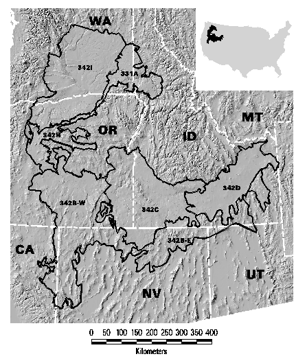
Figure 1. Location of the Columbia Plateau Ecoregion
This ecoregion was selected for development of a prototype ecoregional plan by The Nature Conservancy for both practical and conservation reasons. From a practical standpoint, the ecoregion was among the first for which the requisite land-cover and land management mapping were completed by the individual state-level GAP projects (Stoms et al. in press, see also the GAP web site for the Intermountain Semi-Desert Ecoregion). Very little land in the ecoregion has been designated for maintenance of biodiversity, while potentially conflicting land uses such as grazing and cultivation are extensive. Enough undeveloped habitat remains, however, for pro-active conservation action to be effective. Thus the ecoregion makes a representative case study that could be applied to other regions, particularly throughout the western U. S. Planning for conservation and ecosystem management within this ecoregion is also underway by the Oregon Biodiversity Project (Vickerman 1996), and the Interior Columbia Basin Ecosystem Management Project (ICBEMP, a joint effort by the U. S. Forest Service and Bureau of Land Management, Quigley et al. 1996). Proposals for new wilderness areas (Merrill et al. 1995), national parks (Wright et al. 1994), and other core reserves (DellaSala et al. 1996) are being discussed.
METHODSOverview of the planning process
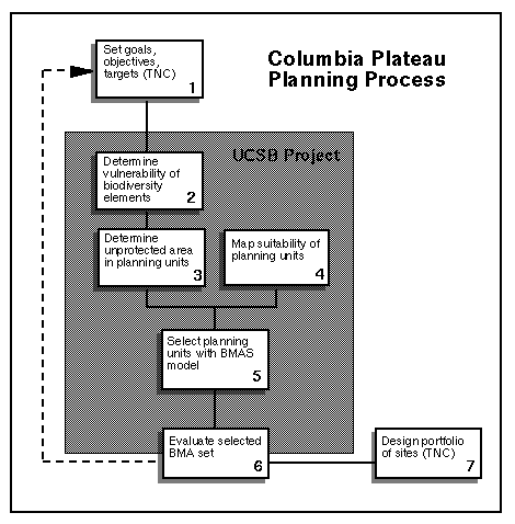
Figure 2. Flowchart of the planning process.
The planning process is outlined in graphic form in seven steps in Figure 2. The first step is to identify conservation goals, objectives, and targets, which was done by the TNC planning team. UCSB conducted steps 2-5 and assisted with part of the evaluation in step 6. In step 2, the spatial data for the distribution of biodiversity elements is summarized to determine which are already represented at or above the predetermined goals of the alternative and which are still vulnerable. For those that are underrepresented, the third step is to quantify the area that is not currently protected for each element in each planning unit. This task identifies the set of planning units that are available to meet the representation goals. Step 4 calculates a suitability index for each planning unit based on precomputed attributes and a set of weights selected for each alternative. These three steps are performed within a GIS, and the results are exported as ASCII files which can be reformatted as input into an external optimal site selection model at step 5. This model, described in more detail in section 3.3 and Appendix 8.1, selects a set of planning units that satisfies the representation goals with the best balance of efficiency (least area) and suitability (best quality or most manageable sites). Data generated by the model is returned to the GIS environment for further analysis and visualization. The arrow from step 6 to step 1 emphasizes that this evaluation can lead to refinements in the assembly rule specifications or to fine-tune an alternative. Similarly, the process can be repeated to test the sensitivity to different parameters such as the choice of goals or the suitability factors. TNC then used the results of the analysis to evaluate the set of sites of the preferred alternative and adjusted the set of sites to design its recommended portfolio as the final step. The process is described in greater detail through the remainder of this section.
Planning stepsIdentify conservation goals, objectives and targets
The planning process begins by setting conservation goals, objectives, and targets for the plan. These can be stated as a set of preliminary decision rules. Specifically, TNC decided what areas to consider currently protected, what sites if any to be "core areas" that must be in all alternative portfolio designs, what biodiversity elements to represent in each alternative (i.e., the targets), and what representation goals must be met for each target element. While this step in the process was conducted by TNC, it is described here to clarify the data used in the analysis and to define terms and concepts.
The first choice is to determine what lands are already managed to protect biodiversity and are thus a baseline in every alternative. Maps of land management status were compiled for the Gap Analysis of the Intermountain Semi-Desert Province (Stoms et al. in press), which contains the Columbia Plateau ecoregion. TNC's definitions are slightly different from GAP's, so the TNC team revised the original GAP land management status map and updated missing or recently designated management areas (Figure 3). All portfolio alternatives analyzed in this report considered category I and II lands as existing biodiversity management areas.
Category I: Lands owned by private entities and managed for biodiversity conservation or administered by public agencies and specially designated for biodiversity conservation through legislative action where natural disturbance events proceed without interference. Examples include many TNC preserves and other private preserves committed to biodiversity conservation and dedicated as state preserves or natural areas, some national parks, some national wildlife refuges, federal wilderness areas, some state parks and nature preserves.
Category II: Lands generally managed for their natural values, but which may receive use (e.g., habitat manipulation for game species) that degrades the quality of natural communities. Also includes public lands for with administrative designations for biodiversity conservation. Examples include many national wildlife refuges, state wildlife management areas, private preserves managed for game species, Bureau of Land Management Areas of Critical Environmental Concern, federal Research Natural Areas, etc.
Category III: Lands maintained for multiple uses including consumptive or recreational values and not specifically or wholly dedicated to biodiversity conservation and lands with restricted development rights. Examples include Department of Agriculture Forest Service and BLM, Department of Defense buffer lands, state forests, regional and large local parks and open space, private lands protected from subdivision by conservation easements or other title restrictions, etc.
Category IV: Lands with no known protection, including lands used for intensive human activity, and agricultural, residential, and urban lands, public buildings and grounds, transportation corridors, etc.
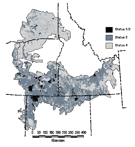
Figure 3. Management status in the Columbia Plateau Ecoregion
In conservation planning, some sites may be so obviously valuable for protection that they can be considered as core areas in any alternative. One popular means of doing this is to convene a workshop of experts to identify the best remaining examples of rare elements. TNC held a workshop, organized along taxonomic lines, in January, 1997. Six panels developed their own set of priority sites. TNC then identified the corresponding subwatersheds that contained these sites and summed the number of workshops that concurred on its importance. The TNC planning team decided that, as a second decision rule, the 105 subwatersheds identified by at least four expert workshops would be allocated as core biodiversity management areas in all portfolio alternatives. (The maximum number of workshops that identified any subwatershed was five). Core areas were combined with existing BMAs to determine remaining vulnerability.
Once the decision rules are established for what lands are or must be protected, the next rule determines what elements of biodiversity should the portfolio represent. The TNC team identified two classes of target elements: vegetation alliances (coarse-filter) and rare elements (fine-filter) from the Natural Heritage databases. Alliances had been mapped for each of the states in the ecoregion using Landsat satellite imagery from 1990 (+/- 2 yrs) and then combined into a regional land-cover map for the gap analysis of the Intermountain Semi-Desert Province (Stoms et al. in press). The smallest land-cover feature mapped is 100 hectares or one square kilometer. Land-cover was classified by alliances (characterized by a diagnostic species of the uppermost stratum of the canopy) or to groups of closely related alliances.
The TNC core team used rare element occurrence data from the various state Natural Heritage programs and state fish and wildlife departments as the fine-filter targets. For vertebrates and invertebrates, the team flagged occurrences to be considered for representation. All plants with global ranking of G1, G2, or G3 were to be represented. For plant associations, only for G1 and G2 communities were picked as targets.
Representation goals for the target biodiversity elements were set as the minimum area or number of occurrences that alternatives must achieve. These goals are estimates of the importance of each element and the amount needed to maintain viable populations. As the TNC core planning team developed representation goals for the coarse-filter alliances as surrogates for other biodiversity elements, they had two implicit goals: to capture not only the cover types but also their range of environmental variability, and to ensure that rare types endemic to this ecoregion were give special attention. Based on these goals, they ranked the cover types by their overall regional distribution, their value as a coarse-filter to cover the plant associations within them, their relative rarity, and their pattern of distribution (i.e., primarily large or small patches). Five groups of cover types were categorized as follows (assignment of cover types to representation goals are shown in Table 1):
Group A: Those which have high or medium coarse filter value, and typically occur in small patches in the landscape. Most of these are restricted to unusual substrate or hydrologic conditions (or maybe even disturbance regimes), and/or are limited in their distribution and so need to be protected in the Columbia Plateau ecoregion. The representation goal should center around capturing 50% of the area of these cover types within each section in the ecoregion if the total area in this ecoregion is small (i.e., < 500 km²). For cover types of greater extent, the goal was set at 25%.
Group B: Those which have medium coarse filter value and occur in relatively small patches. This is an interesting group of alliances, and contains two different patterns of vegetation types: those that are more characteristic of neighboring ecoregions but nevertheless have relatively large disjunct areas and are important within the Columbia Plateau (e.g., some of the forest types on isolated mountain ranges); and some of the less common Artemisia alliances with limited ranges of distribution. Most of these have total areas of < 500 km². The goal for this group was set at 20% representation within each section the type occurs in.
Group C: All those with high to medium coarse filter value and typically found in big patches. This includes the vegetation types that really "distinguish" the Columbia Plateau from surrounding mountainous ecoregions: Juniperus Woodlands, Artemisia shrublands, big sage - low sage, Atriplex salt desert, perennial grasslands. Most of these are very heterogeneous containing many associations. Several of them cover >10,000 km² and all are over 1000 km² in size within the ecoregion. The representation goal was set at 10% within each section.
Group D: Those which have low coarse filter value and which are mostly in small patches. These are primarily vegetation types which are only peripherally in the ecoregion because of the vagaries of the boundaries. Their primary range of distribution is outside of this ecoregion, and so most protection will not occur in the Columbia Plateau. These cover types were assigned no representation goal.
Group E: Cover types or land uses of no conservation interest, such as developed and cultivated lands and exotic or planted grasslands. Water bodies were included only because aquatic features are not well mapped at the regional scale of Gap Analysis. This group also had no representation goal.
Table 1. Representation goals for land-cover types
Land-cover type Mapped distribution (km²) Group A coarse-filter < 500 km² (50% goal) Seasonally/temporarily flooded cold-deciduous forest 382 Populus tremuloides woodland 184 Quercus garryana woodland 463 Non-tidal temperate or subpolar hydromorphic rooted vegetation (marsh and wetland) 482 Sparsely vegetated sand dunes 345 Sparsely vegetated boulder, gravel, cobble, talus rock 69 Group A coarse-filter > 500 km² (50% goal) Pinus ponderosa woodland 5,804 Artemisia rigida dwarf shrubland 700 Temperate deciduous shrub types--Mountain brush 2,027 Cercocarpus ledifolius or C. montanus shrubland 516 Purshia tridentata shrubland 1,140 Seasonally/temporarily flooded cold-deciduous shrubland 1,279 Sarcobatus vermiculatus shrubland 3,576 Seasonally/temporarily flooded sand flats 1,670 Group B small patch communities (20% goal) Abies species (A. concolor, A. grandis or A. magnifica) forest or woodland 1,397 Picea engelmannii and/or Abies lasiocarpa forest or woodland 83 Pseudotsuga menziesii forest 2,149 Populus tremuloides forest 740 Pinyon woodland (Pinus edulis or P. monophylla) 165 Pinyon-juniper woodland (Pinus edulis or P. monophylla with Juniperus osteosperma or J. scopulorum) 193 Pseudotsuga menziesii woodland 27 Artemisia cana shrubland 536 Artemisia tripartita shrubland 3,696 Artemisia nova dwarf-shrubland 164 Group C large patch communities (10% goal) Juniper woodland (Juniperus osteosperma or J. scopulorum) 2,101 Juniperus occidentalis woodland 18,380 Artemisia tridentata ssp. vaseyana shrubland 17,181 Artemisia arbuscula-A. nova dwarf-shrubland 1,816 Artemisia tridentata-A. arbuscula shrubland 45,144 Artemisia tridentata shrubland 64,574 Mixed salt desert shrub (Atriplex spp.) 11,304 Dry grassland Pseudoroegneria (Agropyron)-Poa 15,671 Moist grassland Festuca 2,671 Group D peripheral communities (0% goal) Pinus contorta forest 176 Pinus ponderosa forest 153 Pinus ponderosa-Pseudotsuga menziesii forest 784 Pinus monticola-Thuja plicata forest 20 Pinus flexilis or P. albicaulis woodland 104 Pinus contorta woodland 22 Pinus jeffreyi forest and woodland 2 Alpine tundra 3 Wet or dry meadow 30 Group E cultivated, developed types and water (0% goal) Agropyron cristatum seedings, Poa pratensis, hayfields, and Conservation Reserve Program lands 8,169 Annual grasses Bromus tectorum, etc. 10.177 Urban or human settlements and mining 1,201 Agriculture 69,820 Water 3,568 The TNC core team also set representation goals for the rare element occurrences. For every rare vertebrate and invertebrate, the team set a goal of five representations (i.e., subwatersheds) for each in every section it occurred in. If there were less than five mapped occurrences in a section, then the goal was to represent all occurrences for that species. The goal for plant species was similar with three exceptions. Plants in the Palouse section (331A in Figure 1) were to have up to seven representations because this particular section has been the most heavily impacted by cultivation. Third, plants identified by the core team as endemic to a single section were also given a goal of up to seven representations. For plant associations, the goal was for up to five representations per section. For modeling purposes, an area of 1000 ha was arbitrarily assigned to each subwatershed in which target elements occurred, and the goal was set to 1000 times the number of required occurrences. In essence this amounts to adapting the BMAS model to a covering problem where each element needs to be covered n times.
Determining remaining vulnerability and unprotected area
Vulnerability was determined by comparing the spatial extent of each target element within existing BMAs (category I and II lands) plus core areas with the area required to meet the representation goal within each section of the ecoregion (step 2 in Figure 2). If an element falls short of the representation goal, its remaining vulnerability is calculated as the difference in area. For vulnerable elements, data are summarized on the extent of the element for each planning unit (i.e., subwatershed) in the section (Step 3 in Figure 2). These two steps are performed by GIS overlay of the maps of land management and subwatersheds with the maps of the target elements. (See also Appendix 8.3 for the ARC/INFO AML used to process the GIS files to measure vulnerability and generate the data files for the BMAS model.
Map suitability of planning units
TNC needed a means of integrating programmatic, economic, and socio-political factors into the portfolio design process (Question #3 in the Introduction, McKendry and Machlis 1991). These factors can be collectively termed as "suitability." Mapping the suitability of landscapes for various uses has been a cornerstone of planning since the technique was popularized by Ian McHarg (1969). Factors known to constrain or facilitate a specific land use are overlaid to derive a site suitability map. Therefore, a set of attributes were generated for each planning unit (i.e., the HUC6 subwatersheds) to provide measures of habitat condition, site manageability, and spatial factors (Table 2). The index is scaled such that high values are the least suitable, which is required to maintain the minimization objective of the BMAS model.
Table 2. Suitability factors used in evaluating and selecting alternative portfolios of sites
Roadedness: The presence of roads creates negative impacts on many species, including fragmentation, noise, edge effects, hunting pressure, predation by pets, spread of disease, and invasion of exotic pests. An index of roadedness can provide a useful indicator of habitat condition. Road data were obtained from the ICBEMP project, which had processed the 1990 census TIGER files. Additional 1:100,000 scale data for some Nevada counties outside the ICBEMP study area were obtained directly from the TIGER CD-ROMs and processed in a similar manner. The road arcs were buffered with a buffer width related to the class of road. This buffer operation was used to estimate the area of land actually impacted by the presence of each road, where freeways were assumed to affect a greater spatial extent than dirt roads. This operation also accounted for the spatial distribution of roads which a simple measure of road density (i.e., km of road length per km² of area) does not. For instance, urban streets could total a long length but because they are so closely spaced, they do not affect as large an area of habitat as a similar length of road spread uniformly across a subwatershed. The roadedness index was calculated by summing the total area of buffered roads per subwatershed and converting the area to a percentage of subwatershed area. Values ranged from roadless (i.e., index = 0) to fully roaded (index = 100), with a mean value of 15.95%.
Human Population Density: The presence of large numbers of people represents similar impacts as roadedness and may also indicate higher land values. Population data from the 1990 census data were obtained from CIESIN [ftp://ftp.ciesin.org/pub/census/usa/grid/pall/us/]. CIESIN had interpolated block group data to a 1 km lattice of the United States. We converted this lattice into a grid and cropped it to the ecoregion. By summing population from all the cells in a subwatershed and dividing by subwatershed area, an estimate of population density was derived. Values ranged from 0 to 1710.5 people per km2 (regional mean of 5.2), with high values indicating urbanized subwatersheds that would generally be unsuitable for protection of most forms of native biodiversity.
Expert Opinion: In addition to their use in picking core areas, the number of concurring expert workshops for the remaining subwatersheds (i.e., values from 0-3) was used as another suitability factor, where higher values were presumed to be more suitable. The mean value for these non-core areas was 0.8.
Aquatic Integrity Index: As most of the suitability factors addressed terrestrial habitats, the planning team chose this index developed by the ICBEMP project to represent suitability of aquatic habitats. The index was computed for the HUC5 watersheds (one level above subwatersheds in the hierarchy) as a mean of three component indices of fish community integrity. The three components were a relative index of strong populations of key salmonids, a relative index of the ratio of native species diversity to total species diversity multiplied by native species evenness, and a relative index of species richness within the parent subbasin. The minimum value of this index was 0 for very poor sites and 0.883 for the best watersheds, with a regional mean of 0.326.
Percent of Land in Private Ownership: The cost of changing land management to better protect the long-term viability of native biodiversity is partly a function of current land ownership and management. Therefore we have included an index of the proportion of land in a subwatershed that is in private ownership (either individuals or corporations), derived from the land ownership/management coverage developed for Gap Analysis (Stoms et al. in press). Values ranged from 0 to 100 percent (regional mean of 46.3), with high values indicating watersheds with high probable costs for management of biodiversity.
Percent of Land Converted to Human Uses: As landscapes become more modified by human actions, it becomes more difficult to maintain large-scale ecological processes needed to sustain ecosystems. The GAP land-cover map was reclassified into native communities and human modified cover types. The latter included developed and agricultural lands, exotic annual grasslands, and seedings of crested wheatgrass. The areal extent of human land use types was summed by subwatershed and then divided by its area to convert to a percentage. Values ranged from 0 to 100 (mean of 29.6), with high values of the index indicating highly modified landscapes.
Distance from Existing BMA or Core Area: The current BMAS model has no explicit mechanism for considering spatial relations in selecting a set of planning units. To satisfy the core team's desire to achieve some level of clustering of selected units, the distance from "seed areas", which were the existing BMAs and the core areas (which were identified by at least four expert panels), was added as another suitability factor. Thus planning units nearer these seed areas had a lower factor score and hence were considered more suitable than those farther away. An ARC/INFO GRID was created with the existing BMAs plus the core areas with a 1 km cell size. A distance grid was generated using the EUCDISTANCE command in GRID, assigning a value to each cell. Then the ZONALSTATS command with the MIN option was used to determine the minimum distance value among the cells in each planning unit to the nearest seed area. The distance values range from 0 (adjacent planning units) to 109.55 km, with a regional mean of 18.18 km.
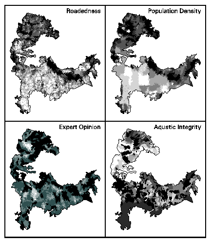
Figure 4. Map of individual suitability factors (Darker areas are least suitable)
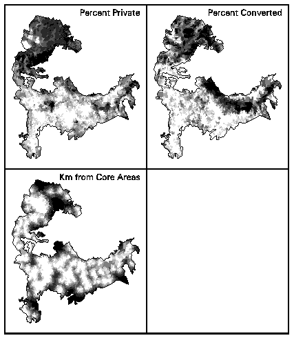
Figure 4. Map of individual suitability factors (continued) (Darker areas are least suitable)
The suitability factors may seem redundant, representing similar positive and negative socio-political, economic, or environmental aspects of planning units. Nevertheless they are generally not highly correlated (Table 3). The highest correlation between pairs of factors was 0.52 between percent private land and percent converted land. Roadedness and percent converted had a correlation of 0.41, while that for roadedness and percent private was 0.37. Population density was not as correlated with roadedness as one might expect, with a correlation value of only 0.27. The aquatic integrity index and the number of expert panels generally had small negative correlations with the socio-political factors. Distance from core area was extremely correlated with the overall suitability index because the distance index was weighted so highly in calculating suitability.
Table 3. Correlation matrix and weights of suitability factors
Default Weight Population Density # Expert Panels Aquatic Integrity % Private Land % Converted Distance from Core Overall Suitability Roadedness 0.2 0.27 -0.15 -0.06 0.37 0.41 -0.01 0.12 Population Density 0.2
-0.04 0.04 0.12 0.17 0.01 0.30 # Expert Panels 0.2
0.04 -0.17 -0.19 -0.32 -0.37 Aquatic Integrity 0.2
-0.12 0.004 -0.12 -0.11 % Private Land 0.2
0.52 0.16 0.24 % Converted 0.2
0.08 0.20 Distance from Core 5.0
0.95
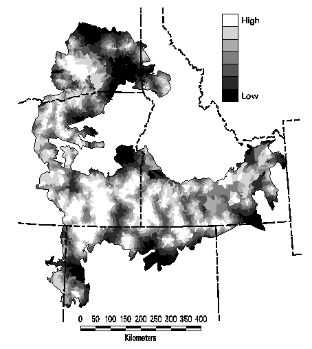
Figure 5. Map of the overall suitability index based on default weights
For each alternative, an overall suitability index would be computed as the weighted sum of the individual factor values. Weighting was a two-step process. First each factor was divided by its regional mean value to normalize the values. Then a set of weights were chosen to emphasize specific factors. A weight could be set to zero if the factor was to be ignored in a particular alternative. The default set of weights, shown in Table 3, gave greatest emphasis on the distance to core areas, which had the effect of clustering selected sites near these core areas. The suitability factors are displayed individually in Figure 4 and as an integrated suitability index based on the default weights in Figure 5.
Sites with low suitability (i.e., a high index value) were not automatically excluded from consideration in selecting alternative portfolios. Such sites may contain irreplaceable biodiversity elements that must be in the portfolio in order to achieve representation goals. If there is a choice of sites to represent the same element, those that are most suitable will be selected.
Select planning units with the BMAS model
It is necessary to select enough area for biodiversity management options that we keep elements from being considered vulnerable. Since we might consider hundreds of elements to be vulnerable and we can select from among hundreds of planning units for targeted action, the problem is relatively complex. We can represent this decision problem as an integer-linear programming model where the objective is to optimize the selection of suitable areas for biodiversity management such that enough area is selected for each element to keep it from being considered vulnerable. We have formulated an optimal siting model that addresses trade-offs between the efficiency and the overall suitability of reserve systems. Each planning unit is described by its area, its biological properties, and by non-biological properties that make it more or less suitable for conservation management. Our multi-objective model, which we have dubbed the Biodiversity Management Area Selection (BMAS) model, selects sites to meet the predefined representation goals while balancing the dual objectives of efficiency and suitability. Either a planning unit is selected as a BMA or it is isn't. This is enforced by the definition of the integer decision variables and is formalized in constraints. Further details about the formulation of the model can be found in Davis et al. (1996) and in Appendix 8.1.
Unfortunately, the BMAS model is related to the class of n-p hard problems that can be found in the integer programming literature (like the travelling salesman problem). Basically, worst-case instances of large n-p hard problems may require an inordinate amount of computer time to solve optimally. Consequently, much of our past research has been focused on the design of a robust heuristic to solve the BMAS problem. Our heuristic is based on the combination of several well-known methods including greedy, interchange, and multiple drops and adds (which represents a form of strategic oscillation). In testing the heuristic against known bounded solutions for selected problems, heuristic performance was consistently within 2% of optimality. The details of the approach are given in Okin (1997).
Evaluate selected set of planning units
The BMAS model operates independently from the GIS database so the output report (see an example in Appendix 8.4.1) can only contain information about which planning units were selected and some summary information about total area and cumulative suitability. The identity of selected sites is therefore imported back into the GIS environment for additional spatial analysis and visualization. (The ARC/INFO AML and awk scripts are listed in Appendix 8.4). Once in the GIS environment, the BMAS solution for the alternative can be portrayed as a map, making it easier for analysts to evaluate the sites in relation to other GIS data (e.g., land ownership or management) or with their personal knowledge about individual sites. To facilitate the evaluation, another program (Appendix 8.5) was written to summarize all GIS data about any individual subwatershed, i.e., target elements it contains, its management and ownership, and its suitability factors. This evaluation can lead to modification of the initial decision rules and generation of new alternatives or to refinement of the set of sites in the recommended portfolio (step 7). The TNC planning team conducted this part of the evaluation.
Another aspect of evaluation is to determine how efficient an alternative is, based on one set of biodiversity elements, at meeting the representation goals for another set. This coincidental representation of one set of targets by another has been termed "sweep analysis" (Kiester et al. 1995). We used sweep analysis to evaluate how many of the vegetation alliances and rare elements would be swept, or represented by, the set of conservation planning units identified in the expert workshops. The planning units picked by five workshops were assigned as core areas and the number of elements not swept by them was determined by repeating planning step 2 to calculate their remaining vulnerability. This process was repeated for planning units identified by at least four workshops, three, two, and one.
TNC was also interested in a policy question about the role of public and private lands in a potential portfolio. Given that conservation strategy is often more feasible to implement on public land, TNC asked whether the region was flexible enough to allocate a greater share of the sites in the BMAS solution from public lands. And if this were possible, what was the trade-off in efficiency? To answer this questions, the suitability index was modified from the baseline alternative by giving much greater weight (5.0 vs. 0.2) to the percentage of private lands in a subwatershed. The BMAS model was run for this variation (with all other parameters held the same) and the spatial pattern of the two alternatives were compared, along with their respective proportions of public and private lands. Because the suitability index is calculated differently in the two alternatives, it is not possible to compare cumulative suitability.
Alternatives consideredBy modifying the set of conservation targets, representation goals, existing biodiversity management areas, and suitability weights, any number of alternative portfolios can be generated. As this modeling approach is exploratory and since there were no requirements for a full range of alternatives as would be the case for a federal land management decision, a relatively small set of alternatives were generated in this study by varying the decision rules. Alternatives were generated for the land-cover types alone (coarse-filter), rare elements alone (fine-filter), and both cover types and rare elements together (integrated coarse- and fine-filters). The representation goals were fixed as described in section 3.2.1, with the default suitability weights. These goals applied to each of the seven sections of the ecoregion. Managed areas in categories I and II were assumed to be protected in all alternatives. All subwatersheds identified by at least four of the six expert workshops were automatically included in every alternative as core areas. Thus for each alternative, there were three types of site in the portfolio: existing reserves, core areas from the experts, and additional subwatersheds selected in the BMAS model to achieve the representation targets.
Next Section