

What's New
Research & Projects Publications
People
Data
Links
PRESERVE SELECTION MODELING IN THE COLUMBIA PLATEAU
Alternatives
Every alternative included 9,693 km² in existing status category I and II lands and 9,145 km² in the 105 subwatersheds identified as important by the expert panels. The results of the alternatives are shown in Table 4. The coarse-filter alternative only sought representation of the vegetation alliances in each section as mapped by GAP, of which 122 of the 195 target elements were considered vulnerable. [Note that our use of the term ``vulnerable'' is based on representation and is different than TNC's definition, which is based on global distributions]. An additional 185 subwatersheds were selected to achieve the representation goals (Figure 6), basically doubling the total area of existing BMAs and core areas.
Table 4. Comparison of alternatives
Alternative Existing BMA area (km²) Additional core area of 105 subwatersheds (km²) Additional watershed area selected (km²) Total area (km²) # of watersheds selected by BMAS Total suitability index Coarse-filter 9,693 9,145 19,240 38,078 185 582.2 Fine-filter 9,693 9,145 50,779 69,617 501 2,980.3 Integrated coarse- and fine-filter 9,693 9,145 56,353 75,191 567 3,245.7
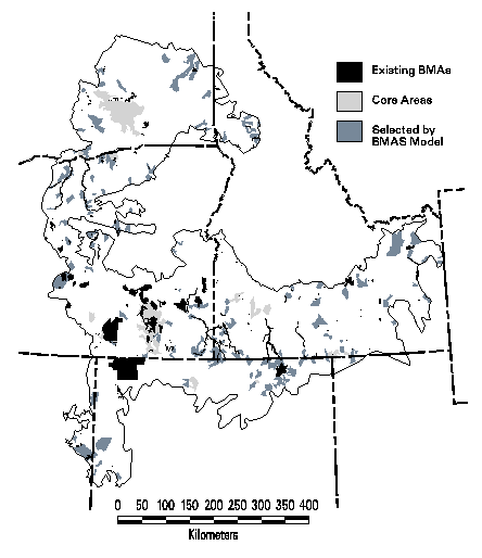
Figure 6. Map of the coarse-filter alternative
Representing the 359 rare species and plant associations that are vulnerable required substantially more area (501 subwatersheds, Figure 7) because the locations of these target elements tend to be widely scattered. Whereas the area of the subwatersheds containing these rare elements was approximately 160% greater than the area for representing GAP alliances, the suitability index was more than 400% greater. Thus even the most suitable subwatersheds containing rare elements (mean index of 5.9) was much less suitable than those for alliances (mean index of 3.1). This result indicates that there are many more options of where alliances can be represented than the relatively few sites available for rare elements. This lower overall site suitability should also not be surprising because many of the rare elements are only found in isolated habitat fragments in cultivated areas.
The integrated coarse- and fine-filter alternative found some efficiencies in representing both sets of elements (481 vulnerable elements) simultaneously (Figure 8). The total area and number of subwatersheds selected were substantially less than the sum of the coarse-filter and fine-filter alternatives taken individually. Mean suitability index (5.7) was similar to that of the fine-filter sites, however, because representing rare elements does not leave much flexibility without selecting very low suitability sites. In fact, 273 of the 359 rare target elements occur at no more sites than required by the representation goals. Thus all their occurrences had to be selected, making 321 of the 567 subwatersheds "irreplaceable."
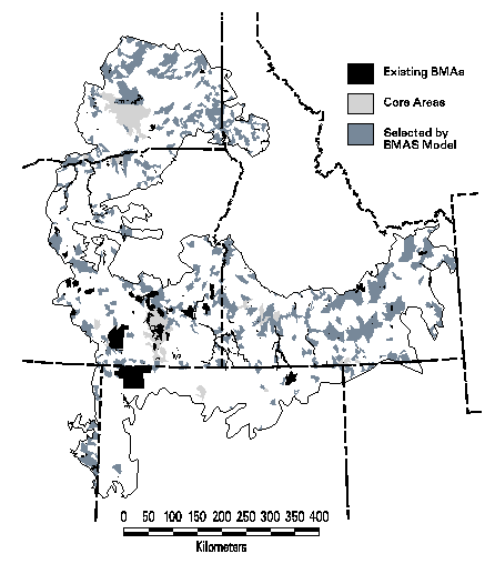
Figure 7. Map of the fine-filter alternative
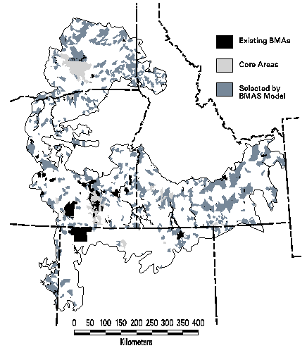
Figure 8. Map of the integrated coarse- and fine-filter alternative
Sensitivity and sweep analysisThe analysis of coarse- and fine-filter elements by the planning units identified by the expert panel workshops is shown in Table 5 in terms of area and number of subwatersheds covered and number of elements left vulnerable (i.e., with area below the representation goal. The number associated with the expert alternative is the number of workshops, out of six, that independently identified the planning unit as a priority. Even if every planning unit identified by at least one panel were selected, or 2,681 subwatersheds covering greater than 63% of the ecoregion, 18 of the 195 vulnerable land-cover types would remain vulnerable to some extent. If only the 105 subwatersheds were selected in which at least 4 panels concurred, only 6% of the ecoregion would be selected but 122 land-cover types would not reach their representation goals. Thus while the expert panel approach is unquestionably useful to identify some critical high priority sites, it is inadequate, at least in the Columbia Plateau ecoregion, as a means to represent other measures of biodiversity. At best, it is inefficient with most of the ecoregion identified as a priority for at least some taxonomic group (at the resolution of subwatersheds). At worst, when only those sites on which the experts concur are chosen, many other target elements are not adequately represented.
The policy question about the relative role of public and private lands in assembling a conservation portfolio was addressed by comparing the results of the integrated coarse- and fine-filter alternative to a variation which strongly favored public lands. The public lands alternative was only slightly less efficient than the baseline alternative. Total area selected was 57,173 km², an increase of 1.5%, and actually selected one less subwatershed. However, the two alternatives shared 530 planning units in common, with only 36 unique to the public lands alternative and 37 unique to the baseline. Further, while the baseline had a public/private mix of 47.5/52.5%, the public land alternative shifted this only to 49.1/50.9%. These findings suggest that even with a very heavy weighting to favor public lands in the BMAS solution, the outcome was quite similar to the baseline. Evidently, the rarer elements occur primarily in habitat remnants on private lands. This makes their planning units irreplaceable in any portfolio with the given representation goals. Hence, for the Columbia Plateau there is relatively little flexibility in achieving this set of goals.
Table 5. Results of the sweep analysis by the subwatersheds identified by the expert panels.
Number of Expert Panels Additional core area (km²) Total BMA Area including existing (km²) # subwatersheds selected by experts # remaining vulnerable land-cover types (out of 195) 5 2,439 12,132 18 130 4-5 9,145 18,838 105 122 3-5 26,741 36,434 319 103 2-5 73,850 83,543 986 59 1-5 181,729 191,422 2,681 18
CONCLUSIONS AND RECOMMENDATIONS TO TNC
Answers to research questions
At the beginning of the report, we posed three questions that this research would attempt to answer. Here we summarize our findings with respect to the questions.
1. What set of assembly (i.e., decision) rules provides the most efficient method for designing and assembling a portfolio of sites to maintain all viable native species and community types within a target ecoregion (i.e., how can TNC maximize the amount of biodiversity protected within a given number of conservation sites or amount of land area)?
The planning process used in this prototype developed a set of assembly rules that generated the most efficient portfolio of sites that met TNC's goals for coarse-filter representation of vegetation alliances and fine-filter representation of rare species and plant associations. In doing so, the modeling approach was able to select a set of highly suitability sites that met the criteria of being relatively undisturbed by human activities, more easily managed for biodiversity, and were close to a set of core areas. In summary, the assembly rules ultimately selected by the core planning team include:
1) Include all existing status 1 or 2 managed areas
2) Add all subwatersheds in which at least four of the six expert panel workshops identified sites as high priority for conservation
3) Use the BMAS model to select a set of sites that complement the core areas from rules #1 and #2 in meeting the specified coarse- and fine-filter representation goals while maximizing efficiency and suitability. To implement this rule, the core planning team also had to decide upon rules for suitability factors and their weights, biodiversity elements to represent, and their representation goals.
4) Modify the BMAS set of sites as appropriate based on local knowledge of site conditions or unresolveable socio-political issues
According to the TNC planning team, the new portfolio satisfied their intention for greater representation beyond the known occurrences of rare elements. The sites selected through the BMAS modeling process generally made sense to the team when examined in detail for which elements they contained. Some sites selected were ones the state offices had been considering for inclusion in their portfolio but had not yet done so. Many sites in the existing portfolio were not selected in the new planning process, evidently because more efficient (and/or suitable) sites were available to represent the same elements.
Using expert workshops is a popular approach for setting conservation priorities, and one that is being used by TNC in several ecoregions. While not used to assemble the portfolios from the six states in the Columbia Plateau ecoregion, we wanted to examine how well the priorities from the expert workshops swept the various biodiversity targets. Because the experts were not asked to identify sites to represent alliances, it is not surprising that these coarse-filter targets were not swept well by the sites chosen by experts for other objectives. Even if every site identified by any of the six workshops was in a portfolio, covering 63% of the land area in the ecoregion, 18 of the 195 land-cover targets were inadequately represented and hence would still be vulnerable. And the subwatersheds with sites identified by at least four of the six workshops (i.e., the ones used as core areas in the preferred alternative) left 63% of the land-cover types vulnerable.
Thus the expert opinion approach can identify sites with the best representatives of the target elements studied by the group. The approach lacks any explicit representation goals for measuring overall conservation achievement. Incorporating the sites agreed upon by the most experts from different biological specialties as core areas, as was done in the Columbia Plateau study, takes advantage of the collective knowledge of these experts while adding an objective means for meeting all goals efficiently.
2. How sensitive is the portfolio to the way in which biodiversity is measured (e.g., what are the effects of using a coarse-filter (alliances from Gap Analysis) or fine-filter (rare element occurrences for species and plant associations from Heritage programs)?
Alternative portfolios based on cover types and rare elements yield vastly different solutions in terms of number of subwatersheds and total area selected and generally do not provide adequate representation, or sweep, each other (Table 4). With the representation goals for rare elements set by the TNC planning team, many sites are irreplaceable in both the fine-filter and the integrated alternatives. Thus there is a good deal of overlap for any alternatives involving rare elements. Suitability of sites becomes a much less important consideration. If the representation goals were set lower than the number of occurrences, then the alternatives could become more sensitive, i.e., fewer irreplaceable sites.
3. How can TNC integrate programmatic, economic and socio-political factors into the portfolio design process without sacrificing its biodiversity goals?
Clearly the primary mission of TNC is to protect biodiversity. Yet there are a number of factors that constrain the manner in which the organization is able to achieve its primary goals. Recognizing these constraints in the portfolio design process will undoubtedly be more efficient than having to respond to them during implementation. BMAS has been formulated to enforce that biodiversity goals are achieved (in terms of the desired level of representation, Mink) while minimizing the impact of these other factors. We have attempted to address these assorted factors through the use of the second objective in the BMAS model, namely suitability. The suitability index has been computed to integrate factors, derived from existing GIS coverages, about the effects of roads, human settlements, and land ownership and use. Collectively, these factors define the manageability of each watershed for long-term maintenance of biodiversity, both in terms of existing condition (and potentially of restoration needs) and of the cost and political impact of establishing biodiversity management areas. The use of weights in combining the various factors into the overall index allows the relative importance of each factor to TNC's design philosophy to be recognized. Further, the weighting can be modified as part of a sensitivity analysis to determine either the significance of individual factors or to explore alternative themes. For instance, we greatly increased the weight on the percentage of private land to evaluate the consequences of greatly favoring public over private lands in the portfolio. Because the solution was quite similar to the original integrated alternative, the distribution of biodiversity in the Columbia Plateau ecoregion, particularly rare elements, is such that private lands are critical for achieving portfolio goals.
Some socio-political issues may be specific to certain sites known to TNC's planning team but are not mappable across all sites in the ecoregion. An example would be where a land owner's management objectives are known to be in unresolveable conflict with TNC's. In such cases, these planning units could be flagged as unavailable for selection by the BMAS model (i.e., would be modeled as a constraint where the appropriate Xj had to be equal to 0). In this project, integration of local expertise was done through a site-by-site evaluation by the planning team, with fine-tuning to modify the initial solution from the computer model. Adding such detailed knowledge at this step reduces the effort by the planning team which only has to deal with reviewing candidate sites rather than trying to document everything they know about the entire pool of planning units.
Recommendations to The Nature ConservancyThe major purposes of a pilot study such as this are to learn the advantages and limitations of the process, to recommend actions for implementation of the prototype on a wider basis, and to identify future research needs revealed by the study. This final section, therefore, concludes with a set of recommendations for TNC's ecoregion planning process.
Although reserve selection algorithms produce solutions that may not be the best when scrutinized using better data or additional criteria, they have proven to be powerful indicative tools and very effective at facilitating understanding, group planning and negotiation (Pressey et al. 1995). The planning approach applied in the Columbia Plateau ecoregion guarantees that specific representation goals are achieved. While these goals may only be estimates of the effort needed to conserve biodiversity, they at least are explicit in the prototype process and can be modified in future revisions if new information becomes available. Scoring and expert opinion approaches, in contrast, are good at identifying high quality sites but do not attempt to represent all varieties of biodiversity. They are also labor-intensive and therefore do not lend themselves to exploration of alternatives (e.g., changing the scoring system). We believe that a BMAS type of modeling technique and the expert approach are complementary and can be used effectively in tandem. The expert process integrates knowledge of site quality that is not easily incorporated into the modeling approach. Specifically we recommend:
1. TNC use expert panels to identify a set of core areas that must be protected in any portfolio, followed by the BMAS or a similar model to select additional planning units as needed to meet the representation goals.
The BMAS model can be formulated to cluster additional sites around these core areas and to give extra weight to non-core areas that were nevertheless identified by some of the experts. Alternatively, instead of assigning core areas, the sites identified by many expert groups could be given very high suitability weights to make it more likely, but not guaranteed, that the model will select them.
The BMAS modeling approach is a useful exploratory tool for evaluating the consequences of alternative choices in targets, representation goals, suitability factors, and policy questions. The BMAS model is able to sort through large, complex, multi-dimensional data sets to maximize a balance between efficiency and suitability, which would be beyond the capabilities of a human analyst. We emphasize two critical points, however.
2. The set of planning units selected by the model should not be accepted on faith as an ideal portfolio. The model solution only forms a starting point of a portfolio. The planning team members must still apply their own intimate knowledge of specific sites to refine the portfolio, using personal knowledge not explicitly in the GIS database nor incorporated in the BMAS model. Ideally, more testing of model assumptions and parameters will be undertaken to understand their implications and trade-offs.
3. The cartographic representation of the set of planning units (i.e., subwatersheds) is not a map of the precise boundaries of conservation sites. The locational accuracy of the biological data is imperfect and so some target elements may actually occur in adjacent planning units. This selection error could be remedied during the design/implementation phase. The use of standardized planning units is just an artificial convenience for modeling purposes. Therefore the set of planning units merely indicates general locations where appropriate management strategies can be applied. In the extreme, a subwatershed may be selected in which the only strategy required is to monitor the status of a single target element occurrence at a small site within a planning unit. In other words, displaying a portfolio from this prototype planning process as a set of large planning units risks overstating the magnitude of the conservation agenda and alarming other stakeholders. We strongly urge caution in how TNC publicly portrays any portfolio derived in part by BMAS modeling based on subwatersheds or other such planning units. Noss (1996), in commenting on this question, recommended that network proposals be presented to policymakers and the general public as a staged sequence from the current system, through intermediate stages, to the ultimate network. He felt that presenting the ultimate vision was worth the risk because it may stimulate others to conduct more detailed analyses in the design phase.
The basic conservation planning approach, including the BMAS model, has now been applied in the Sierra Nevada Ecosystem Project for the U. S. Forest Service and the Columbia Plateau ecoregion for TNC. Both of these ecoregions were data-rich study sites, having been the focus of major federal assessment efforts. Large GIS databases had already been assembled for most of the essential spatial data layers such as suitability factors and biodiversity target elements. Gap analysis had recently been completed for both these regions which also provided important data. As GAP is implemented in more regions, and as public-domain GIS layers become more commonly available, lack of data for other regions of the nation should diminish as a limitation. Perhaps more significantly, both regions are largely in public ownership with relatively limited area converted to development and cultivation. Thus there remain substantial opportunities for proactive conservation action. Because of the similarity of these two test sites, it remains untested which circumstances would preclude the effective use of the BMAS model. Obviously, in an extreme case of a highly altered ecoregion in which all remaining fragments with rare elements were known, all such sites would be in the portfolio and a more formal modeling approach would add nothing useful. But what circumstances define the threshold at which the BMAS model becomes an effective planning tool? Therefore we recommend:
4. TNC undertake additional pilot studies in ecoregions across a range of management situations, including more highly altered landscapes in the eastern half of the nation.
Perhaps the single greatest failing of the modeling approaches to date is that they tend to treat sites as collections of species or communities without accounting for the viability of the biota at each site or over the set of sites. The goal of representation is only an approximation of the true goal of maintaining viable populations of all native species. Similarly, management status only approximates the actual underlying threats to biodiversity. A second, related problem is that none of the current selection models addresses the problem of the spatial layout of the sites. Since sets of sites may all be influenced, potentially in different ways, by the same large-scale ecological processes (e.g., fire, floods), consideration of spatial layout may relate to the long-term viability of the sites. Another critical issue is whether conservation planning solutions developed at the regional scale using spatially and biologically coarse data provide reliable guidance when viewed from a more local perspective with better data and understanding of ecological processes and management concerns. Our final recommendation is:
5. TNC should conduct or sponsor research to address three issues we consider central to ecoregion-based conservation, namely: 1) development of approaches and techniques for assessing species and community-level viability under a particular conservation scenario, 2) development of improved, multi-objective models for identifying the best set of sites within a region for meeting the stated conservation goal while addressing viability and spatial configuration, and 3) testing of regional viability measures and siting solutions against more detailed information on biotic composition and ecosystem processes to establish the relationship between regional and local conservation measures and approaches.
ACKNOWLEDGMENTSThis research was supported by a contract from The Nature Conservancy of Washington (WA-FO-101796). We appreciate the enthusiasm and energy of the Columbia Plateau team leader, Sandy Andelman, who was willing to take risks in exploring new planning directions. We also thank the other TNC staff involved, particularly Elliot Marks, Director of the Washington State Office; the planning team members; and Chris Hansen for GIS assistance. The formulation of the BMAS model was the vision of Dr. Richard Church at UCSB. Much of the spatial data were compiled by the Interior Columbia Basin Ecosystem Management Plan team and by the network of Natural Heritage Programs. We are also grateful to the IBM Environmental Research Program for its gift of computing support.
LITERATURE CITEDBailey, R. G. 1995. Description of the Ecoregions of the United States, 2nd ed. rev. and expanded. USDA Forest Service, Miscellaneous Publication 1391, Washington, D. C., 108 pp. with separate map at 1:7,500,000.
Bedward, M., Pressey, R. L., and Keith, D. A. 1992. A new approach for selecting fully representative reserve networks: Addressing efficiency, reserve design and land suitability with an iterative analysis. Biological Conservation 62: 115-125.
Church, R. L., D. M. Stoms, and F. W. Davis. 1996. Reserve selection as a maximal covering location problem. Biological Conservation 76: 105-112. [Abstract on-line]
Davis, F. W., and D. M. Stoms, 1996. A spatial analytical hierarchy for Gap Analysis, in J. M. Scott, T. H. Tear, and F. W. Davis, editors. Gap Analysis: A Landscape Approach to Biodiversity Planning. American Society for Photogrammetry and Remote Sensing, Bethesda, MD, pp. 15-24. [Abstract on-line]
Davis, F. W., D. M. Stoms, R. L. Church, W. J. Okin, and K. N. Johnson. 1996. Selecting biodiversity management areas. Pages 1503-1528 in Sierra Nevada Ecosystem Project: Final Report to Congress, vol. II, Assessments and scientific basis for management options. Davis: University of California, Centers for Water and Wildlands Resources. [Abstract on-line]
DellaSala, D. A., J. R. Strittholt, R. F. Noss, and D. M. Olson. 1996. A critical role for core reserves in managing Inland Northwest landscapes for natural resources and biodiversity. Wildlife Society Bulletin 24: 209-221.
Faith, D. P. and P. A. Walker. 1996. Integrating conservation and development - effective trade-offs between biodiversity and cost in the selection of protected areas. Biodiversity and Conservation 5: 431-446.
Kershaw, M., G. M. Mace, and P. H. Williams. 1995. Threatened status, rarity, and diversity as alternative selection measures for protected areas - a test using Afrotropical antelopes. Conservation Biology 9: 324-334.
Kiester, A. R., J. M. Scott, B. Csuti, R. F. Noss, B. Butterfield, K. Sahr, and D. White. 1996. Conservation prioritization using GAP data. Conservation Biology 10: 1332-1342.
Kirkpatrick, J. B. 1983. An iterative method for establishing priorities for selection of nature reserves: an example from Tasmania. Biological Conservation 25: 127-134.
Lo, T. H. C., S. E. Dicks, and R. Christianson. 1989. Targeting natural resource lands for acquisition within the context of a GIS framework. Proceedings of GIS/LIS '89. American Society for Photogrammetry and Remote Sensing, pp. 685-698.
Margules, C. R., A. O. Nicholls, and R. L. Pressey. 1988. Selecting networks of reserves to maximise biological diversity. Biological Conservation 43: 63-76.
McHarg, I. L. 1969. Design with Nature. The Natural History Press, Garden City, New York.
McKendry, J. E. and G. E. Machlis. 1991. The role of geography in extending biodiversity gap analysis. Applied Geography 11: 135-152.
Merrill, T., R. G. Wright, and J. M. Scott. 1995. Using ecological criteria to evaluate wilderness planning options in Idaho. Environmental Management 19: 815-825.
Noss, R. F. 1996. Protected areas: How much is enough? Pages 91-120 in R. G. Wright and J. Lemmons (eds.), National Parks and Protected Areas: Their Role in Environmental Protection, Blackwell Science, Cambridge, Massachusetts.
Okin, W. J. 1997. A Heuristic to Solve the Biodiversity Management Area Problem. Masters Thesis, University of California Santa Barbara.
Pressey, R. L., M. Bedward, and D. A. Kieth. 1994. New procedures for reserve selection in New South Wales: maximizing the chances of achieving a representative network. Pages 351-373 in P. L. Forey, J. C. Humphries, and R. I. Vane-Wright, (eds.), Systematics and Conservation Evaluation. Clarendon Press, Oxford.
Pressey, R. L. and Nicholls, A. O. 1989. Efficiency in conservation planningscoring versus iterative approaches. Biological Conservation 50: 199-218.
Pressey, R. L., Humphries, C. J., Margules, C. R., Vane-Wright, R. I., and Williams, P. H. 1993. Beyond opportunism: key principles for systematic reserve selection. Trends in Ecology and Evolution 8: 124-128.
Pressey R. L., Ferrier, S., Hutchinson, C. D., Sivertsen, D. P., and Manion, G. 1995. Planning for negotiation: using an interactive geographic information system to explore alternative protected area networks. Pages 23-33 in Nature conservation 4: the role of networks, eds. D. A. Saunders, J. L. Craig, and E. M. Mattiska. Surrey Beatty, Sydney.
Pressey, R. L., H. P. Possingham, and C. R. Margules. 1996. Optimality in reserve selection algorithms - when does it matter and how much? Biological Conservation 76: 259-267.
Quinn, J. F. and J. Karr. 1992. Habitat fragmentation and climatic change. Pages 451-466 in, J. Kingsolver, P. Kareiva, and R. B. Huey, eds. Biotic interactions and global change. Sinauer Associates, Sunderland, Massachusetts.
Quigley, T. M., R. W. Haynes, R. T. Graham, tech eds. 1996. Integrated Scientific Assessment for Ecosystem Management in the Interior Columbia Basin and Portions of the Klamath and Great Basins. Gen. Tech. Rep. PNW-GTR-382. USDA Forest Service, Pacific Northwest Research Station, Portland. 303 pp.
Reid, T. S. and D. D. Murphy. 1995. Providing a regional context for local conservation action. BioScience Supplement: S84-S90.
Shafer, C. L. 1990. Nature Reserves: Island theory and conservation practice. Smithsonian Institution Press, Washington, D.C.
Stoms, D. M., F. W. Davis, K. L. Driese, K. M. Cassidy, and M. P. Murray. In press. Gap analysis of the vegetation of the Intermountain Semi-Desert Ecoregion. Great Basin Naturalist. [Abstract on-line]
Stoms, D. M., M. J. Bueno, F. W. Davis, K. M. Cassidy, K. L. Driese, and J. S. Kagan. Map-guided classification of regional land-cover with multi-temporal AVHRR data. Submitted to Photogrammetric Engineering and Remote Sensing. [Abstract on-line]
The Nature Conservancy Ecoregional Working Group. 1996. Designing a Geography of Hope: Guidelines for Ecoregion-Based Conservation in The Nature Conservancy, third draft. Arlington, VA.
Underhill, L. G. 1994. Optimal and suboptimal reserve selection algorithms. Biological Conservation 70: 85-87.
Vickerman, S. 1996. Using gap analysis data for statewide biodiversity planning: Case studies of applied gap analysis for planning of land use and biological resources. Pages 195-208 in J. M. Scott, T. H. Tear, and F. W. Davis, eds. Gap Analysis: A Landscape Approach to Biodiversity Planning. American Society for Photogrammetry and Remote Sensing, Bethesda, MD.
Wright, R. G., J. G. MacCracken, and J. Hall. 1994. An ecological evaluation of proposed new conservation areas in Idaho: Evaluating proposed Idaho National Parks. Conservation Biology 8: 207-216.
Next Section