

What's New
Research & Projects Publications
People
Data
Links
1. INTRODUCTION
Premises of the Gap Analysis Program (GAP)
GAP Inventory of Biodiversity
The California GAP Project
Limitations Of GAP
How This Report Is Organized
The Study Area
Premises of the Gap Analysis Program (GAP)
As a nation we care deeply about our natural resources, including native species and ecosystems. Over the past century we have instituted many statutes and a large system of public and private conservation lands to protect those resources. Unfortunately, many of our native biota occur largely or completely outside of these protected areas and are increasingly threatened by habitat loss and degradation. Conserving these elements of biodiversity will require an expanded, representative system of biological reserves, combined with the judicious and sustainable use of unreserved lands. To accomplish this we must first identify the "gaps" in the current set of conservation lands and then identify areas that provide the best opportunities for covering those gaps, that is, for protecting the most vulnerable species and habitats in a way that is ecologically sound and cost-effective.
GAP Inventory of Biodiversity
The U. S. Geological Survey-Biological Resources Division's Gap Analysis Program (GAP) brings together the problem-solving capabilities of federal, state, and private scientists to inventory and assess the conservation status of several components of the nation's biodiversity. Digital maps are created of actual vegetation, predicted distributions of terrestrial vertebrates, land ownership and land management. These maps are combined to identify individual species, species-rich areas, and vegetation cover types that are not well represented in existing management areas. Gap analysis functions as a preliminary step to the more detailed studies needed to establish actual boundaries of new conservation areas. The data and results are made available to institutions as well as individual land owners and managers concerned with resource management and conservation planning. The data also serve a larger user group of educators, researchers and other interest groups.
Biodiversity inventories can be visualized as "filters" designed to capture elements of biodiversity at various levels of organization. The Nature Conservancy employs a "fine" filter of rare species inventory and protection and a coarse filter of community inventory and protection (Jenkins 1985, Noss 1987). It is postulated that 85-90% of species can be protected by the coarse filter, without having to inventory or plan reserves for those species individually. A fine filter is then applied to the remaining 15-10% of species to ensure their protection. GAP is a coarse filter method that aims to assess the other 85-90% of species relatively quickly and cheaply. The cover types mapped in gap analysis are intended to serve directly as a coarse filter, the goal being to assure adequate representation of all types in biodiversity management areas.
There are five major objectives of GAP:
- map actual terrestrial vegetation as closely as possible to the Alliance level (actual vegetation structure and dominant overstory species) (Jennings 1993),
- map the predicted distribution of those terrestrial animals for which adequate distributional habitats, associations, and mapped habitat variables are available,
- identify vegetation types that are inadequately represented (gaps) in special management areas,
- identify animal species that are inadequately represented (gaps) in special management areas, and
- make all GAP information available to users in a readily accessible format.
Additional data layers can be used for a more holistic conservation evaluation. These include indicators of stress or risk (e.g. human population growth, road density, rate of habitat fragmentation, distribution of pollutants) and the locations of habitat corridors between wildlands that allow for natural movements of wide-ranging animals and the migration of species in response to climate change. These more detailed analyses are areas of research that GAP as a national program is pursuing.
The California GAP Project
Considerable resources have been invested in conserving California's biodiversity on both public and private lands, which account for 52.2% and 47.8% of the state, respectively. Although many efforts are focused on single species or site-specific issues, particularly in response to federal and state endangered species legislation, there is growing recognition of the need to consider common as well as rare species and to coordinate biodiversity conservation and management over broader planning "bioregions" that are defined based on ecological as opposed to purely political boundaries. In fact, bioregionalism has guided most major conservation initiatives in California since 1990, when major federal and state resource agencies signed a "Biodiversity Memorandum of Understanding" to encourage collaboration and database development within ten physically and biologically defined regions. Regional assessments and planning initiatives have been undertaken in many areas, as exemplified by the Natural Communities Conservation Plan for southwestern California, the Sierra Nevada Ecosystem Project, the Bay Delta Plan, the San Joaquin Recovery Plan, the Klamath Ecoregion Restoration strategy, the Coastal Salmon Initiative, and the Mojave Desert Planning Initiative. One of the major challenges facing all of these regional initiatives is the lack of coherent, reliable regional databases on land and biota in a format that are useful for analysis and decision making.
Since 1990 we have undertaken a gap analysis of California (CA-GAP) with cooperation and collaboration from dozens of public and private organizations (see Acknowledgments). The analysis required preparing statewide maps of land management, vegetation, and wildlife habitats. Given the physiographic and biological complexity of California, we also conducted separate analyses of land-cover for each of the state's geographical regions, as delineated in The Jepson Manual (Hickman 1993, Figure 1-1). The Jepson regions are similar but not identical to the bioregions adopted by the Biodiversity Executive Council, the latter being defined by both political and physiographic features, and to those in the Forest Service's ECOMAP regionalization (Bailey 1995). California GAP data and information have been developed at a level of spatial and thematic detail to meet the objectives of the national program, and they can also contribute to ongoing regional and statewide analyses such as those mentioned above.

Figure 1-1. Shaded relief image of California depicting the ten regions used in the California Gap Analysis Project.
Limitations of GAP
- GAP data are derived from remote sensing and modeling to make general assessments about conservation status. Any decisions based on the data must be supported by ground-truthing and more detailed analyses.
- GAP is not a substitute for threatened and endangered species listing and recovery efforts. A primary argument in favor of gap analysis is that it is proactive: it seeks to recognize and manage sites of high biodiversity value for the long-term maintenance of populations of native species and natural ecosystems before individual species and plant communities become critically rare. Thus, it should help to reduce the rate at which species require listing as threatened or endangered. Those species that are already greatly imperiled, however, still require individual efforts to assure their recovery.
- The static nature of the GAP data also limits their utility in conservation risk assessment. Our database provides a snapshot of a region in which land cover and land ownership are both very dynamic and where trend data would be especially useful.
- GAP is not a substitute for a thorough national biological inventory. As a response to rapid habitat loss, gap analysis provides a quick assessment of the distribution of vegetation and associated species before they are lost and provides focus and direction for local, regional, and national efforts to maintain biodiversity. The process of improving knowledge in systematics, taxonomy, and species distributions is lengthy and expensive. That process must be continued and expedited, however, in order to provide the detailed information needed for a comprehensive assessment of our nation's biodiversity. Vegetation and species distribution maps developed for GAP can be used to make such surveys more cost-effective by stratifying sampling areas according to expected variation in biological attributes.
How This Report Is Organized
The organization of this report follows the general chronology of project development, beginning with the production of the individual data layers and concluding with analysis of the data (Figure 1-2). Unlike standard scientific reporting, results and discussion sections are embedded within individual chapters. This was done to provide data users with a concise and complete report for each data and analysis product.
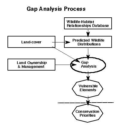
Figure 1-2. Flowchart of the California Gap Analysis Project.
We begin with details on mapping land cover (Chapter 2), predicted animal distributions and species richness (Chapter 3), and land ownership and management (Chapter 4). The Analysis section reports the extent and conservation status of natural communities (Chapter 5) and terrestrial vertebrate species (Chapter 6). Finally, we describe the management implications of our findings Chapters (7 and 8, and provide information on how to acquire and use the data ( Chapter 9).
More detailed accounts of the gap analysis of land-cover in each of the ten Jepson regions are presented as appendices. Each regional chapter follows a common outline, beginning with a characterization of the planning region, followed by summary descriptions of land stewardship, plant community types, and priority conservation areas. For bioregions that extend into other states, a corresponding analysis may be done in collaboration with neighboring Gap projects and reported separately. For instance, Stoms et al. (in press) present a gap analysis of the Intermountain Semi-Desert Ecoregion, which includes a small portion of California's Modoc Plateau.
The Study Area
By any standard, California is one of the world's most biotically diverse regions, in large part thanks to its size, topography, and the wide variety of climatic regimes and soils (Mooney 1988). The California flora includes over 5,800 native vascular plant species, or roughly 25% of the flora of the continental U.S. (Hickman 1993). With its long latitudinal and elevational range, California provides habitat for species of both tropical and boreal origin. One thousand, four hundred and sixteen species (24.2%) and 737 subspecies or varieties are endemic to the state. Because of this high level of endemism, the California Floristic Province has been identified as a global "hot spot" (Myers 1990, WCMC 1992).
The state's terrestrial vertebrate fauna includes 673 native species. The International Council for Bird Preservation identified southern and central coastal California as a globally significant "Endemic Bird Area" and rated it "High" in terms of biological importance for restricted range species and degree of threat (ICBP 1992, Long et al. 1996). In addition to this rich array of individual species, the state contains an incredible variety of natural communities. The California Natural Diversity Data Base recognizes 380 types of communities, 260 of which are terrestrial (Holland 1986). Many of these communities are also endemic to California.
Other authors have identified several ecological areas of the state as being globally or nationally significant and at high risk. The World Wildlife Fund lists four ecological areas as being among the highest risk in the nation: California coastal sage and chaparral, Sierra Nevada forests, Klamath-Siskiyou forests, and Northern California coastal forests (Ricketts et al. 1997).
During the past century the State's remarkable native biota has been seriously diminished by agricultural, residential and industrial development, overharvest of renewable plant and animal resources, and by the spread of naturalized, alien species. Six hundred plant taxa and 200 natural communities are now considered endangered or threatened with extinction, and some 200 natural plant communities have been significantly reduced from their original distribution (Jones & Stokes 1987, Jensen et al. 1990). Two hundred and twenty animals are threatened or endangered or considered to be at risk. The projected future is also disturbing. California's population is projected to increase nearly 60% from 1990 to 2020 (California Department of Finance data, 1997), further reducing and fragmenting some of the state's most imperiled communities. The southwestern coastal region alone is projected to expand to 20 million residents. In some regions that we currently think of as wildlands, the rates are even greater than the state projections (e.g., Mojave and Sonoran Deserts and Sierra Nevada). Therefore it is very timely to conduct an assessment of the current distribution, extent, and management of California's to identify conservation needs. Identifying which plant communities and wildlife species appear most vulnerable under current management can guide state and bioregional planning in mitigating the effects of projected urbanization and other land uses on biodiversity.
CA-GAP Home | Overview | Report | Download GIS | CD-ROM | Site Index | National GAPTop of Page Send your comments to: stoms@geog.ucsb.edu
UCSB Biogeography Lab Home